Traffic Calming on Western Ave. – Make It Happen

The following letter to Albany Mayor Kathy Sheehan calls for Traffic Calming on Western Ave.

The Albany Bicycle Coalition proposes the logical extension of the Madison Ave. bicycle lanes from their terminus at S. Allen and Madison Ave./Western Ave. to the city line. There they will join the Town of Guilderland’s long established bicycle lanes at the city line/University at Albany. These combined lanes would provide just over 4 miles of safe cycling for riding to work, school, errands, and health care. It would afford an option for those wishing to avoid COVID-19-risk buses or environmentally damaging petrovehicles. It would also provide safe, affordable commuting for those who do not have access to a motor vehicle.

Your support can make the happen:

++++++

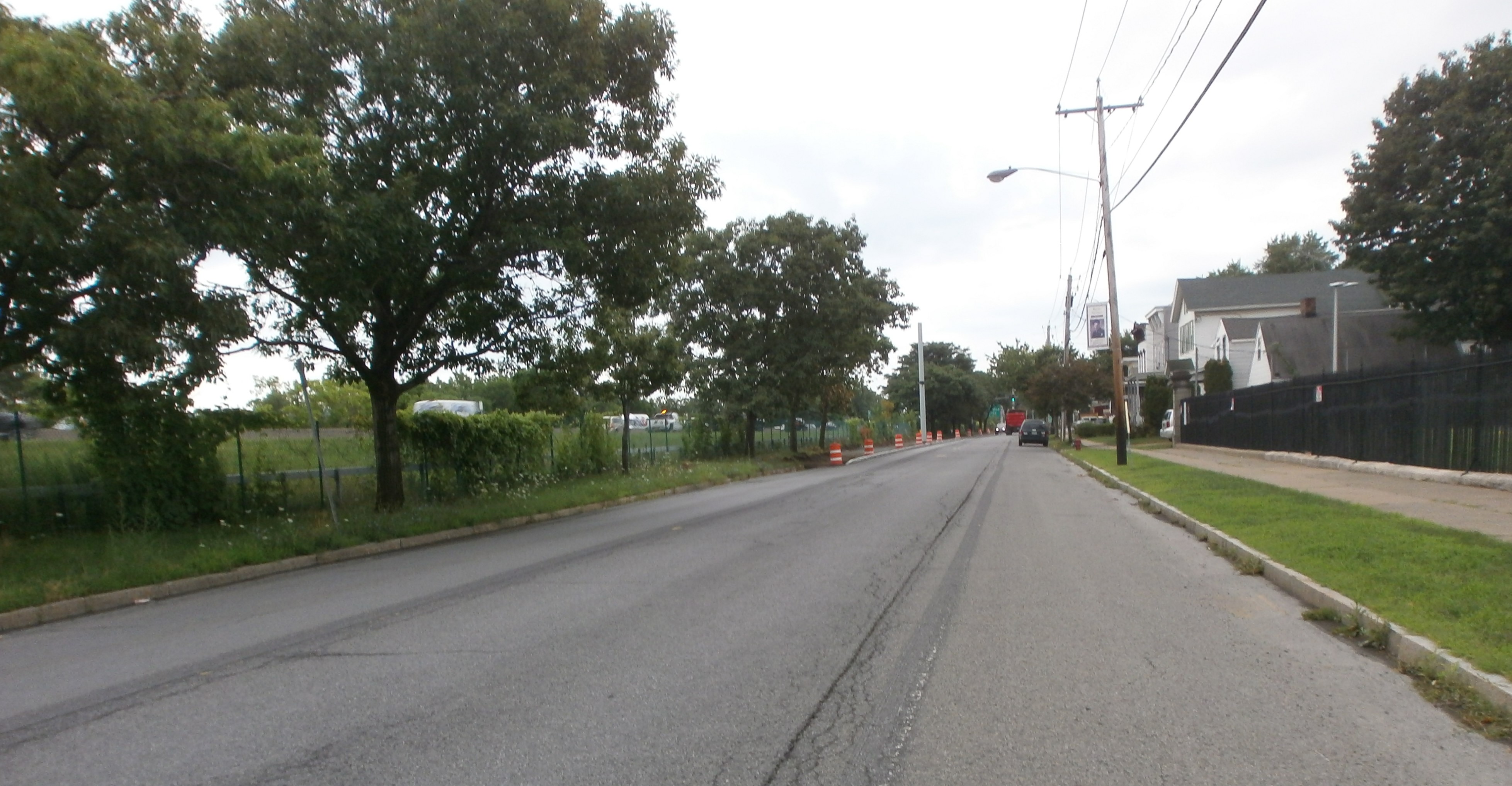
Plenty of Room from Here to the City Line – Build It!

OLYMPUS DIGITAL CAMERA

The Wide Open Western Horizon

++++++

July 30, 2020

RE: It’s Time for Western Ave. Traffic Calming

The Honorable Kathy M. Sheehan

Office of the Mayor

City Hall, Rm. 10224 Eagle St.
Albany, NY 12207

Dear Mayor Sheehan:

As we come off the high of opening the South End Connector, it’s time to revisit an old favorite – connecting the City of Albany and Madison Ave. to Guilderland.

Over the past years, motorists, bus patrons, pedestrians, and cyclists have adapted to Albany’s highly successful Madison Ave. Traffic Calming initiative. The four-lane, crash-prone thoroughfare is now a pleasant urban street on which to drive, walk, bus, cycle, and patronize businesses. The new programmed/on-demand traffic lights and pavement markings allow Madison Ave. pedestrians to cross at every light between Allen and Willet Sts. without having to touch a button. Motorists cruise along at 20-30 mph without fear of being rear ended in the left-turn lane or experiencing unannounced, sudden lane changes. Drivers have become accustomed to cyclists and cyclists have flocked to Madison as a major uptown-downtown connector. It has been a boon to CDPHP Cycle! BikeShare users and to growth of the BikeShare program.

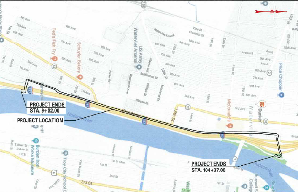
The Town of Guilderland and the NYSDOT recently refreshed the Western Ave. bicycle lanes running from the city line/University at Albany to Stuyvesant Plaza.

It is time to connect these Madison and Western Ave. projects into a seamless, calmed commuter and recreational route. Western Ave. from UA to Madison has two schools with posted 20 mph zones and many business and residences with exiting and entering traffic. The too-wide double lanes encourage speeding and crazy lane changes threatening everyone’s safety. This is an ideal street for Traffic Calming. This wide street section with essentially no parking has ample room for buffered bicycle lanes without impeding the smooth flow of motor vehicle traffic.

This approach will create a street design that matches the posted speed and gives all users a safe and efficient route from Guilderland to downtown Albany. It will address the inequities of those who are “car less,” those who feel unsafe on crowded buses, and those who value environmentally sound, safe solo exercise.

Mayor Sheehan, you know all of the features and benefits already and that this is an ideal street for Traffic Calming. The street’s pavement is in pretty good shape so this is an easy lift – no big bucks for utilities, curb cuts, and so on. In its 2009 Bicycle Master Plan, the City of Albany identified Western Ave. as one of its 18 “major bikeways” and will likely so re-designate it in the new Albany Bicycle/Pedestrian Master Plan. We seem to be on the cusp of a “bicycle boom” brought about by the COVID-19 conditions (Times Union 5/8/20; New York Times 6/13, 15, 19 and 25/20; Adventure Cyclist 8/20). “We are selling bikes faster than we can assemble them out of the boxes … I can’t tell you how crazy it is,” stated the Freeman Bridge Sports service manager in the Times Union

The City of Albany will have to do this job someday. Why not now?

I ask your support in raising this project to the “can do” level. We look forward to working with you and staff to bring it about.

Sincerely yours,

Albany Bicycle Coalition, Inc.

+++++


Leave a comment

Filed under Activisim, Bike Lanes, Support the Cause, Western Ave.

Uncle Sam Trail Progress Report – July 30

SEE UPDATE 9/25/20 AT END

Background – Troy’s Uncle Sam Trail has been through many years of planning. Its original configuration, the off-road Uncle Sam Bikeway, connecting Middleburgh, and North Sts. stood in isolation.

Cycle Tracks On Division St. (Left) and River St. (Right)

The big breakthrough was installation of shared lanes, bicycle lanes, and cycle tracks from the Rt. 378 Bridge/High St. to State St. just south of the heart of downtown. From here, on-road portions connected to the off-road Bikeway at Middleburg St. See the BikeAlbanyMap of an overview of the entire route. The Uncle Sam Trail is part of the major trail network in the Capital District Transportation Committee’s Trails Plan (see pg. 34) and is, of course, part of Troy’s Trail Connection Plan.

Access to the Unlace Sam Trail – People on bicycles can access the trail via and of the following additional points:

  • 2/Congress St. Bridge from Watervliet
  • Green Isl. Bridge from Green Isl. Those entering Troy from Green Isl. can turn left at the Troy side of the river and then take an immediate left to aces the Trail. When crossing the bridge, position yourself in the left lane and then in the left-turn lane.
  • Ontario St./Rt. 470/112 St. Bridge from Cohoes
  • Broad St./126 St. Bridge from Waterford. This last crossing is just under a mile on city streets to the northern terminus of the Uncle Sam Trail (formerly “Bikeway”).

Promotion – Over the years, Transport Troy hosted its annual Collar City Ramble, frequently escorted by Troy’s Mayor, to show the planned route to visitors. Parks & Trails New York and the City of Troy coordinated on some “pop up” demonstration street configurations in several locations. Capital Rootsand its volunteers added art in the form of decorated intersections/cross walks. The Albany Bicycle Coalition always includes exploration of the route in its group rides through Troy.

Moving Ahead Along the River – The next step is replacing or augmenting the on-street portions with a trail running along the Hudson River waterfront, under the Green Isl. Bridge and along the water. At present, much of the construction along the river is near completion.

Riverfront Park Looking North – Note New Sidewalks

OLYMPUS DIGITAL CAMERA

All the new segments from the Bar-B-Que/Green Isl. Bridge north are open as far as City Hall/Hutton St., to the pocket park under the Rt. 7/Hoosick St. Bridge, and then onto VanDerHeyden St. and River St. At VanDerHeyden, people on bicycles have to use the sidewalk if the ramp gate is closed.

The Promenade Looking North Behind the Bar-B-Que And Going Under The Green Isle. Bridge

OLYMPUS DIGITAL CAMERA

 From The Promenade Looking South with View of Riverfront Park and Boat Mooring Facility (Note Barrier)

OLYMPUS DIGITAL CAMERA

From The Promenade under the Green Isle. Bridge Looking South with Starbucks Isle. To The Right

OLYMPUS DIGITAL CAMERA


(Text Cont’d)

There is then a short hop on the ever-busy River St. to Middleburgh.

 Entrance to the Waterfront Portion of the Uncle Sam Trail from River St. At VanDerHeyden St.

OLYMPUS DIGITAL CAMERA

 Ode to a Disappearing Bicycle Lane on Middleburgh St. – Where Did It Go?

OLYMPUS DIGITAL CAMERA

 Leaving Middleburgh St. onto River St. – Lots Of Motor Vehicle Traffic

OLYMPUS DIGITAL CAMERA

 Can You See This?

OLYMPUS DIGITAL CAMERA

As of this post (7/30), construction still blocks end-to-end travel but it won’t be long! Even with most of the path blocked, one can enter at Hutton St., go under the Rt. 7/Hoosick St. Bridge, and then exit at VanDerHeyden.

Leaving the River Front Multiuse Path toward River St. On VanDerHeyden St. – Gates Closed? Take the Sidewalk!

OLYMPUS DIGITAL CAMERA

Bicycle Path of Car Park?

As a positive note, the “Bar-B-Que/Green Isl. Bridge promenade” finally eliminates the bicycle/pedestrian “pinch point” the Bar-B-Que at the North end of River Front Park. However, people on bicycles who are on the sidewalk in front of the Bar-B-Que must dismount if pedestrians are present.

 The Current Cycling-Pedestrian “Pinch Point” By the Bar-B-Que – Note Promenade behind Construction Barriers

OLYMPUS DIGITAL CAMERA

View Of The Promenade Looking South from Under Green Isle. Bridge – Note Ongoing Construction

OLYMPUS DIGITAL CAMERA

Promenade Looking South with View of Green Isle. Bridge and River St. Retail on the Left

OLYMPUS DIGITAL CAMERA

 Promenade Looking North to City Hall and the Collar City Rt. 7/Hoosick St. Bridge

OLYMPUS DIGITAL CAMERA

 Second View from the Promenade Looking North To City Hall, the Collar City Bridge, and Construction Ongoing

 It’s a Bird, It’s a Plane, It’s a …. Bike Rack?

OLYMPUS DIGITAL CAMERA

 Hard At Work!

OLYMPUS DIGITAL CAMERA

 Promenade Entrance/Exit under the Green Isle. Bridge – Note Plantings and Rock Garden with Construction On Going in the Near Distance with City Hall and the Collar City Rt 7 Bridge in the Far Distance

OLYMPUS DIGITAL CAMERA

 View Back To the South from the Above Exit Area

OLYMPUS DIGITAL CAMERA

 Riding South on the New Uncle Sam Trail

OLYMPUS DIGITAL CAMERA

Uncle Sam Trail Heading North to the “Pocket Park” Underneath the Collar City Bridge

OLYMPUS DIGITAL CAMERA

 Working On a Laptop in the Collar City Bridge “Pocket Park”

OLYMPUS DIGITAL CAMERA

River St. – A New Beginning – The Times Union featured the long-awaited River St. connection from Division St. to High St./Burden Ave. on 7/23/20. The vision is that this will also be a connection for people on bicycles. The section from Main St. to Monroe St. is under construction with the Monroe St. to Adams St. planned. Ultimately, there will be a river front bikeway from Rt. 378/High St. to Adams St. Here the path will re-join the existing Uncle Sam Trail. The Times Union photo shows Mayor Madden – under whose administration many of these changes have occurred – posing with the project engineers.

South Troy Industrial Rd. Project Northern View near Burden Iron Works Museum – County Jail on the Left

OLYMPUS DIGITAL CAMERA

 South Troy Industrial Rd. Project Southern View near Burden Iron Works Museum – County Jail on the Right

OLYMPUS DIGITAL CAMERA

 Scene at the Industrial Rd. Project Site

OLYMPUS DIGITAL CAMERA

Long term, Troy’s river front bikeway will connect to the city of Rensselaer at the recently completed Rensselaer Waterfront Esplanade. There will then be connection to the Albany-Hudson Electric Trail providing largely off road or bicycle lane access from N. Troy/Lansingburgh to Hudson with the river crossing to the City of Albany via the Dunn Memorial Bridge. “Someday” the Livingston Avenue Bridge Coalition may be successful in getting the return of the “water level” bicycle crossing on the 100-year-old railroad bridge (or its replacement).

Ren Cnty CDTC Trail Plan

 Access – The Uncle Sam Trail is readily accessible from the Mohawk-Hudson Bike-Hike Trailon a (curiously unmarked) serpentine connection a few yards north of the Rt. 378 Bridge. Once across the Hudson River, people on bicycles can follow the trail to the Burden Ave. intersection with Mill St. and proceed north on shared lanes (with shared lanes markings visible from, Mars). The beloe photo shows the path, the 378 bridge, and the MHBHT just before completion in 2010.

The Serpent Showing the Path, the Rt. 378 Bridge, and the MHBHT (2010)

OLYMPUS DIGITAL CAMERA

 ++++++


*** UPDATE 9/25/20 ***

The Uncle Sam Trail promenade behind the bar-b-que restaurant and under the Green Isl. Bridge is complete.

Bicycle wise, the path behind the bar-b-que restaurant is very narrow (see photo) and would not allow for someone on a bicycle and someone walking to pass by each other. (The photo makes it look wider than it is in “real life.”) A courteous cyclist would likely dismount to let a pedestrian pass by. As in the photos, some construction items remain.

A Short View Looking North

A Short View Looking South
A Long View Looking South

Leave a comment

Filed under City Review, Cycle Track, Transport Troy, Troy Cycling, Uncle Sam Trail

Cycle Track in Watervliet – Coming Soon!

The long awaited safe bikeway and multiuse path through Watervliet is coming to fruition. It originates at the park/trail head/parking lot terminus of the off-road portion of the Mohawk-Hudson Bike-Hike Trail and continues for about one and one-half miles to 23rd St. The “Watervliet Bike Path” will become shared lanes at 23rd St. for access to the Hudson Shores Park.

Map of the Project Area

Bike Way Map 2019

Those continuing to Green Isl. and the Erie CanalwayTrail/Empire State Trailwill continue on shared lanes on Broadway until 25th St. and then follow Albany St. to the Green Isl. Bridge to Troy or Hudson Ave. north – the current route of the Mohawk-Hudson Bike-Hike Trail.

Concept of Broadway Cycle TrackBrdway Near Arsenal EST

Broadway at 4th St. Exiting From the Park/Trail Head/Parking at Current Terminus of the Mohawk-Hudson Bike-Hike Trail

Brdwy & 4th MHBHT Watervliet 6-7-20

We were unsuccessful in getting from the City of Watervliet definitive information on the route and road treatments of the Empire State Trail/Watervliet Bike Path from Watervliet through to Green Isl. We are particularly interested in the treatment around the Rt. 2 Watervliet-Troy Bridge and the aforementioned Albany Ave./Hudson Ave./Green Isl. Bridge intersection. The New York State Department of Transportation 2018 “On-Road Routes Concept Plan” for the Empire State Trail sheds no light on this issue.

Progress Just North Of 4th St. – Note Passano Paints

More progress in Watervliet today

 James Roy Mills 1835 – Now Used By Passano Paints

OLYMPUS DIGITAL CAMERA

 Construction Ahead! (Heading South On Broadway)

OLYMPUS DIGITAL CAMERA

 Cycle Track Route between Motor Vehicle Lane And I-787 Fence (2 Views)

 Cycle Track Base I-787 Fence (North and South Views)

 View South with Arsenal Fence to the Right

OLYMPUS DIGITAL CAMERA

Heretofore, Broadway from the Mohawk-Hudson Bike-Hike Trail at 4th St. was one of the main barriers for less road-hardened riders going on to Troy, Cohoes, the Black Bridge, Champlain Canal Trail, Waterford, and the many sites along the way. The new bikeway is very impressive and will make the ride a wonderful experience. I-787 will be noisy but the bikeway will be safe and relaxing traffic wise.

 Empire State Trail staff graciously provided background resources and some of the information herein.

++++++

2 Comments

Filed under Capital Trails-New York, City Review, Cycle Track, Empire State Trail, Mohawk-Hudson Bike-Hike Trail, Watervliet

Champlain Canal Trail and the Empire State Trail Going North from Waterford

Champlain Canal Trailand the Empire State Trail Going North from Waterford

MAP Champlain Canal Trail Upper Newtown Rd. 7-15-20

One of the nicest rides in the area – from Corning Riverfront Park to Upper Newtown Rd. – just got better. Work is in progress on the trail and towpath from Upper Newtown Rd. to Mechanicville. Formerly, people on bicycles could follow the original Champlain Canal Trail from Broad St. in Waterford, past the Weighlock, and on to “Landfill Mountain” by Momentive Performance Materials. Then, following a narrow paved road onto Bells Ln. (that changes into School House Ln.), you come to the Half Moon Trail skirting the old Champlain Canal on your left. This undeveloped area is about as close as you get to ride along the original canal through its surroundings. You can almost hear the clop-clop-clop of the mules’ hoofs. At 5.3 miles from Waterford, you arrive at a trailhead with parking for 4-5 cars at Upper Newtown Rd. Just across the road is evidence of construction of the new trail – formerly just grass, weeds, and brush.

Champlain Canal Trail Upper Newtown Rd. 7-15-20

This will be part of the Empire State Trail north connecting New York City to Canada. Go here for more detail on the currently rideable portions of the Champlain Canal Trail at Waterford.


View From “Before” July 2016

Trailhead Looking South Toward Waterford July 2016
Waterford Lock No 5
Waterford Weigh Lock from the Tow Path/Trail
Waterford Weigh Lock Looking North

++++++

Leave a comment

Filed under Black Bridge, Capital Trails-New York, Champlain Canal Trail, Empire State Trail, Erie Canal Trail, Trail Network

Proudly Made in America Since 1898 – Worksman Cycles

Before you get concerned about “gender appropriation,” “Worksman” is not a marketer’s dream word – like Sear’s (R.I.P.) “CraftsMAN” or “LeatherMAN” – but recalls the company’s founder, Morris Worksman. He began building local delivery cycles in New York City more than 100 years ago.

“Our Goal is to bring a more efficient, reliable and healthful transportation to modern industry” – Morris Worksman, 1898.

If you were in NYC during the days before “electric motorcycles” as delivery vehicles, you may well have seen a Worksman or two zipping around the streets with deliveries or chained up at a green grocers ready to go.

Worksman_hot_dog_cart

In fact, you may have been lucky enough to get a Good Humor Ice Cream treat or a hot dog from a Worksman cargo bike or cart. Another use for Worksman cycles is ferrying workers, parts and supplies, and tools from and to work stations in industrial settings. A Worksman “look-alike” was spotted at the College of St. Rose in 2013.

Typically, the cargo box for trikes rested either between two steerable wheels with conventional chain power going to a single rear dive wheel or between two powered rear wheels with a single front wheel for steering. The two-wheel bicycle had a small front wheel that left room for a cargo box above the wheel and a swing-down front wheel stand.

Worksman Low Gravity – Model LGB – $609

LGBfunkycolors

Worksman Front Loader – Super Delivery Trike, Model SUD – $1,699

SUDBlue3Lo

A quote from the company president, Wayne Sosin, suffices to establish their “Made-in-America” bona fides. We make the frames, we weld the frames, we powder coat the frames, we assemble the wheels, we weld the rear axle sprockets that are actually made in the U.S. The handle bars are USA, the stem is USA, the steel fenders we use are USA-made.” Most manufacturing is now in S. Carolina although the Ozone Park plant still produces the hot dog and food vending carts.

Nevertheless, and all that aside, what’s available for the recreational or personal transportation cyclist? Worksman has a supplementary line of street-ready cruisers (for bikeshare and rentals), folders, and trikes.

Worksman Port-O-Trike PT2FJR – $485

PTjunior

Worksman Folding Bike 3 Speed FMB3CB – $409

redfolder

This posts sample folder speaks for itself with its photographic portfolio. It features a smooth shifting Strumey-Archer 3-speed hub, coaster brake, and 20 X 1.75”, 35-50 psi tires. This is not a compact fold and will benefit those with a low lift-over to their vehicle’s trunk area. The Chain card carries the company’s slogan, the down tube sings it praises, and the head badge shouts its lineage – “Pleasure Cycles – Ozone Park.”

Ready to ride – 

The fold – 

RESOURCES: https://en.wikipedia.org/wiki/Worksman_Cycles and https://www.americanmanufacturing.org/blog/entry/manufacturing-means-business-for-american-made-worksman-cycles

++++++


Leave a comment

Filed under Bike Tech, Product Review