Category Archives: Bicycle Boulevards

Bicycle Lanes (and Traffic Calming) on Van Rensselaer Blvd./Rt. 377

Van Rensselaer/Rt. 377 Bicycle Lanes – There soon will be two lanes for motor vehicles, left turn bays, and bicycle lanes on Van Rensselaer. These are a great tie-in with Northern Blvd.’s bicycle lanes.

The first photo shows the start of the new lanes (as yet uncompleted) at Northern Blvd.

OLYMPUS DIGITAL CAMERABut there’s more…

NYSDOT is completing this recent project in consultation with the City of Albany on project scope. It builds on the 2015 bicycle lanes/traffic calming installation on Northern Blvd. The city will expand the bicycle lane project on Northern Blvd from the I-90 bridge north toward Albany-Shaker Road later this summer. Notably the lane treatment at the southern end of Northern Blvd. is one of the best designs you will find in the region. Note the bottom photo with a nice buffer.

Those who use the BikeAlbanyMap and Parks & Trails New York Erie Canalway Trail map will note that one can ride the Mohawk-Hudson Bike-Hike Trail from Rotterdam Junction (with a few on-street portions in Schenectady, Cohoes, and Watervaliet), leave the MHBHT at the (hidden and bumpy) Schuyler Flats Trail near Passano Paints and the I-787 underpass at Broadway and 4th Sts. to Schuyler flats, go a short half mile south on Broadway, crawl up the hill through Albany Rural Cemetery, join the above described new bicycle lanes on Van Rensselaer/Rt. 377, enjoy the “calmed” Northern Blvd. to McCrossin and Thornton Sts. at the old Livingston Middle School, and then wind through a quiet residential neighborhood to the bicycle lanes on Clinton Ave.

It’s almost a network!

OLYMPUS DIGITAL CAMERA

4 Comments

Filed under Bicycle Boulevards, Bike Lanes, City Review

Breaking the Ice – Ride #1 South End Bikeway Link

PRE-RIDE – We kicked off the monthly series of planned orientation rides on the proposed South End Bikeway on Saturday, March 7, 2015. Nine intrepid riders – with the youngest being 18 months old – met under the (pounding) I-787 at the Boat Launch/Row Center in the Albany Corning Preserve. We started with a League of American Bicyclists mini “Safe Cycling” course sponsored by the Albany Bicycle Coalition. We had several adults and one youth for the class which featured a description of the full course, helmet selection and fit, pre-ride “ABC Quick check of our bicycles,” signaling, “rock dodge,” and scanning (to the rear).

HEADING OUT – Leaving from the start of the Erie Canalway Trail and the Mohawk-Hudson Bike-Hike Trail, we headed along the current multi-use pathway to the central parking area where we learned about the $8-million Albany Corning Preserve project and the proposed South End Bikeway Link. He pointed out the “flyover” – an adaptive re-use of an unneeded I-787 ramp into a multi-use “high line-like” parkway for people on bicycles and on foot. This would connect the waterfront to Clinton Ave. as well as to the bike-hike path over the new Livingston Avenue Bridge that, in turn, would open a water-level route to Rensselaer and to S. Troy.OLYMPUS DIGITAL CAMERA

A LITTLE ICE – With temps in the high teens, we were bound to, and did, encounter a few icy spots but a little walking or a steady had on the bars got us through that so when we arrived at our next orientation spot at the Slater we were all nicely warmed up. At the Slater, we looked at the terminus of the Albany County path and then to the 1.8-mile on-street gap separating us from the Albany County Helderberg-Hudson Rail Trail head on S. Pearl.

TERMINUS – With the sun getting warmer and warmer, we headed south past the choke point at the U-Haul on Broadway toward Island Creek Waterfront Park (with its potential as a spot where people can begin their rides or walks) where we again paused to look at the planned off-street crossing, the Island Creek Waterfront Park, the UA Alumni Row Center, and the proposed full-service marina on Broadway.

OLYMPUS DIGITAL CAMERAA LITTLE HISTORY – Just before the rough-and-tumble railroad crossing, we looked at the reported site of Fort Nassau, the tank bombs, and the off/on ramps for I-787, one of which will be the protected bicycle lanes for the South End Bikeway Link. We swung around to western ramp, noted the super wide shoulder, and went on to S. Pearl. We stopped at Mt. Hope Drive to hear about Ezra Prentiss, Joel Rathbone, and other historical notables who lived in or settled the area. We learned about the now-vanished Kenwood village and gained an appreciation for the powerful history of the immediate area and how it will enrich the SEBL’s value for all. We observed how critical would be enhanced signalization at Mt. Hope and Pearl to facilitate people crossing form the west side of S. Pearl (from the 2-way cycle track) to the I-787 ramp, one lane of which will become the protected bicycle lanes.

CRAZY STREET – While heading toward the end of our tour, even the experienced road riders noted the aggressive, on-your-tail, outta-my-way behavior of the people in cars and trucks and how meaningless the shared lane markings and “share the road” signs were in helping us along. In covering the route, we noted with sadness the loss of life – Jose Perez (2006) and Qazir Sutherland (2013) in the very streets we are trying to bypass on our preferred route. This enhances the urgency for protected bicycle lanes by this fall in time for the Albany County Helderberg-Hudson Rail Trail opening.

START HERE – At the intersection of South and Old South Pearl, we looked at the railroad overpass, the area of the planned 12-car parking lot, and the to-be-closed pedestrian tunnel under the roadbed. Crossing under the railroad overpass, we swung onto Binghamton St., went to the end, and learned about the Mohawk and the Mohicans. While we did not spot the promised bald eagle, we did see a red-tailed hawk.

TANK BOMBS – At this point, we made our way speedily back on our route, using the eastern I-787 ramp. Our plans to return via Broadway were dashed by the stopped fleet of DOT 111s on the crossing. We noted sadly that yet another 103-tanker train had yet another derailment in Illinois. With 34,500 gallons in each car, the explosion/conflagration caused evacuations in a one-mile radius where the Galena River joins the Mississippi. (By the way, if about half of those gallons was converted to gasoline [the rest being waste, heating oil, spillage, plastic bottles, etc.] an Escalade could go 1,326 miles – well worth it Commissioner Martens!) In any case, we returned to our starting point via Quay St.

For info, go to:

https://www.facebook.com/albanybikewaylink

https://www.flickr.com/albanybikewaylink

https://www.twitter.com/albanybikeway

https://www.facebook.com/albanybikewaylink


Leave a comment

Filed under Activisim, Bicycle Boulevards, Bike Lanes, Rides, South End Bike Link

College of St. Rose Picks Up on ABC Position on Madison Avenue Traffic Calming

The College of St. Rose “Chronicle” nicely picked up on the Madison Avenue Traffic Calming letter ABC sent to Albany Police Department’s Traffic Engineering. ABC voiced support for the “traffic calming” proposals put forth but asked that the bicycle lanes be six (not five) feet wide. This sentiment was echoed in the article by recently re-elected (in the face of anti-bicycle lanes backlash) 10th Ward Common Council Member Leah Golby.

History buffs – and bicycle and pedestrian advocates looking for support for their own cause – will enjoy the comments by City Historian Tony Opalka about the “transposition powerhouse of the day” (the canal lobby) banning railroads from crossing the Great Western Turnpike (Western and Madison Aves.). If you ratchet up the dates to the present and the contenders (motor vehicle/big petro/big construction lobbies vs. cyclists and pedestrians) you’ll see that we are in the same fix today – those who have a right to locomotion are constrained by road and street design from exercising that right in safety.bike-in-traffic

The Text of the ABC letter follows:

Since April 16, 2013 when Creighton-Manning presented its suggested Madison Ave. “road diet” treatments for Madison Ave., the Albany Bicycle Coalition has considered many different approaches, and has concluded that there is only one that maximizes bicyclist safety, and would, therefore, encourage new cyclists. That approach is a modified “Option C” (in-road bicycle lanes), with the bicycle lanes widened to six feet to provide a sufficient safety margin.

By way of explanation, ABC’s goals remain firmly as follows:

• Calm Traffic on Madison Ave. – For the benefit of cyclists, pedestrians, transit users, and motorists.
• Make Madison Ave. the City’s Main East-West Bicycle Corridor – Of our three radial streets, only the Madison-Western Ave. combination offers all the desired benefits without negative impact on other street users. It has all the major destinations and connects easily with all major cross streets. With its expected continuation east to the river and west to Guilderland, it will be the heart of the long-needed “river-to-Fuller” bicycle route.

The consulting engineer’s Madison Ave. traffic calming study suggested only three options to meet the goals of that road diet. The suggested options (with ABC annotations) are as follows:

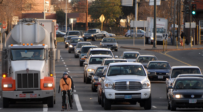
A. Shared Lanes in Travel Lanes – This option is unsuited to most cyclists. While shared lane have been installed elsewhere in the city to great benefit, their use on Madison Ave. would undercut the goal of its being a major route suited to cyclists of all skill levels.
B. Shared Lanes in Parking Lanes – This option seems to be used rarely elsewhere and exacerbates the potential for collisions between cyclists and opening doors of parked vehicles. ABC members who have ridden these “parking-bicycle lanes” found them unsuitable. This option should be considered only as a last resort.
C. Five-Foot Bicycle Lanes – This is the preferred of the three options. However, we believe that five-foot lanes would deter many would-be cyclists. The margin of safety with five-foot bicycle lanes is just not sufficient.

Thus, these three options have extremely limited potential for bringing new cyclists onto the streets. Options A and B might be suitable for experienced cyclists, but those cyclists are already accustomed to riding on streets with no bicycling features at all.

The overarching goal for the City of Albany is to build cycling infrastructure that will attract current non-riders, as well as those who hesitate to ride on the street with motorized traffic. Only by working toward this goal can we realize lower pollution, more parking, less traffic congestion, more public safety, improved health, and increased pedestrian use of the streets.

Consistent with that goal, our position is that a modified Option C – with wider bike lanes – is the best way to bring about the city’s objectives:

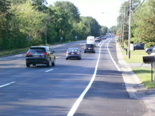
• The consulting engineer’s Option C consists of five-foot bicycle lanes located at the right side of the travel lane, adjacent to the parking lane.
• However, based on our extensive experience, five feet is not sufficient to protect cyclists from car doors, and from wide commercial vehicles parked at the curb.
• Therefore, we propose that the bicycle lanes be a minimum of six feet wide. Our design obtains the extra two feet (total) by subtracting approximately eight inches from each of the three motor vehicle drive lanes.

These modifications are feasible and justifiable. They vastly improve the safety of Option C, and they preserve the intent of the consulting engineer’s proposal. If implemented, they will provide a safe, inviting, Madison-Western east-west bicycle corridor that the city needs in order to become a real bicycling community.

We look forward to working with you and other project staff and supporters to realize the development of the Madison Ave. bicycle route.

Leave a comment

Filed under Activism, Bicycle Boulevards, City Review, Support the Cause

Art and (Bicycle) Access

Art and (Bicycle) Access – 1st Friday Gallery Spin and Bicycle Boulevard Mapping  – A number of new 1st Friday Gallery Spin riders plus some regulars departed the Soldiers and Sailor Monument in Washington Park for the traditional first stop at the Upstate Artists Guild.  The show there, “Fashion and Art,” was a real treat with live models/mannequins showing off some of the wearable entries.  There was a nice array of fashion-themed 2-D art in the main, back, and side galleries, all augmented by a DJ.

We next zipped out Delaware Ave. (love those shared lane makings and signs!) to disrupt the diners at Mingle  by examining an impressive mix of paintings and photographs (including one bicycle-themed piece).  On the way, we waved to baby Indiana and her parents, Laura and Perry, longtime cycling advocates.

We were then off to the Opalka Gallery for a must-see show featuring John Van Alstine, “Arrested Motion/Perilous.  Do not miss this one (ends 10/14/12).  Our last gallery visit was the Massery at College of St. Rose for the closing night of the Art and Design Faculty Show.  As one of our riders expressed interest in displaying his art in Albany, we checked out the Madison Theater windows  where the theater and the Beautify Upper Madison Avenue Project sponsors installations by local artists.  There we saw Matt Ramsey’s commissioned piece for the Upper Madison Street Fair, “When We Destroy the World Around Us, We Destroy Ourselves” and an installation by Kimberly Marks of College of St. Rose student entries to the Street Fair poster contest.  (As a side note, the Upper Madison Street Fair – 2012 will feature an Exotic Bicycle Exhibit .

As an add-on to this 1st Friday Gallery Spin, we were committed to reconnoitering Berkshire Blvd. and connecting city streets.

Berkshire Blvd. is designated officially in the Albany Bicycle Master Plan (page 39) as a “neighborhood bikeway.  Our interest was to explore the possibility of its being the main spine of a bicycle boulevard connecting the western extremes of the city to downtown.  As a bicycle boulevard, this would be a low-volume street optimized for bicycle travel by traffic calming and diversion, signage and pavement markings, and intersection treatments.

Bicycle boulevards are shared roadways that are comfortable and attractive to cyclists with a range of abilities and ages.  Ideally, they are inconvenient as through routes for automobiles.  Bicycle boulevards serve major origins, destinations, and travel corridors and should be as direct and intuitive as possible.  As a residential roadway, Berkshire Blvd. already has low motor vehicle volume and could serve well as a bicycle boulevard. As with many bicycle-focused improvements, there would be spillover benefits to the Berkshire Blvd. community – less speeding, more quiet, enhanced walk-ability.

If it were so designated, some low-cost treatments could include the following:

  • Prioritizing bicycle movement with stop signs that favor the bicycle route
  • Reducing motor vehicle speeds by traffic calming
  • Reducing motor vehicle volumes by traffic diversion
  • Providing crossing improvements at intersections with major streets (refuge islands, signalization, or curb extensions)
  • Helping cyclists find and use the facility with pavement markings and signs with both directional and destination information, which are likely to be destinations

After circling one of Albany’s gens, Buckingham Pond, we headed out Berkshire, crossed Russell Rd., wound through Albany’s 15th Ward, rode trough parts of Bethlehem, and ended up in Guilderland looking across Western Ave. to the glare of Crossgates Mall.  The route we rode – which avoids the high volume/high speed Western Ave. completely – presents political challenges (impact on motor vehicle traffic) and jurisdictional issues (it encompasses streets Albany, Guilderland, Bethlehem, a town park, and some private property).

Our Riders were Sebastian, Jim, John, Filipe, Keith, Paul, and Lorenz.

More to follow . . .

Leave a comment

Filed under Activism, Bicycle Boulevards, City Review, First Friday, Local Bike Rides, Rides, Support the Cause

Where Can I Ride? It’s All About NOW

Want to measure progress on implementation of Albany’s Bicycle Master Plan?  See the “Complete Updates” map.

In 2009, Albany issued its approved Albany Bicycle Master Plan.  This was later adopted by the Albany Common Council within “Albany 2030,” the governing master plan for the entire city.

The ABMP featured a “20-Year Bikeway Network Plan”, an ambitious look forward to major routes, neighborhood bikeways, trails and greenways, and connecting bikeways outside the city limits.  IBI Group Consultants prepared this visionary map under contract with Albany’s Planning Office with input from hundreds of cyclists and other interested persons.

Beginning in 2010 (when Albany boasted about 500 feet (!) of marked bicycle lanes), the city has forged ahead starting with bicycle lanes on Clinton Ave. (0.8 miles) and shared lanes/signs on Washington Ave. (0.6 miles).

Shared Lanes

Shared Lanes

As the city has repaved streets (2012 has been a banner year for this much-needed effort), it has marked many of them with the shared lane icons and signage.  These include Delaware-Lark, Academy, and portions of Western, Main, Manning, Lincoln, New Scotland, Hackett, McCarty and others.

So here’s an idea – print out the “Complete Updates” map and then invite a friend(s) to cruise around the city to visit all the completed sections.  Then – call the mayor during his Friday morning radio talk show (9:00-10:00 AM, 476-1300, AM 1300) and say “thanks.”

(Check back with the Mayor’s Office of Energy and Sustainability for updates.)

Leave a comment

Filed under Activism, Bicycle Boulevards, City Review, Law, Local Bike Rides, Support the Cause