Category Archives: South End Bike Link

Changes to South End Connector – City of Albany

Following substantial completion of the South End Connector, the Albany Bicycle Coalition detected a number of issues needing resolution. We had identified some of these even before design and construction began on the Connector. On 9/17/20, we asked the city to explore how we might get these projects on the city’s “to do” list for 2020-21.

Key members of the Albany Bicycle Coalition have had some considerable experience with the new South End Connector and many years of observation and riding in the S. Pearl St./Connector area. We believe the city should make several modifications to realize the full potential of this new asset. We detail these below. They include maintenance, safety issues, signage/lighting/striping, a new interchange, and traffic control.

Our major concerns are safety issues related to the Broadway/Quay St. and the S. Pearl St.-South End Connector junction. The Broadway/Quay St. issue derives from the original “all cars-all the time” poor design of this interchange. In fact, it was here that a SUV ran down and killed 60-year-old cyclist Jose Perez on August 3, 2006.

One of the major impetuses for the very conception of the South End Connector was the motor vehicle death of a young lad on S. Pearl St.

++++++

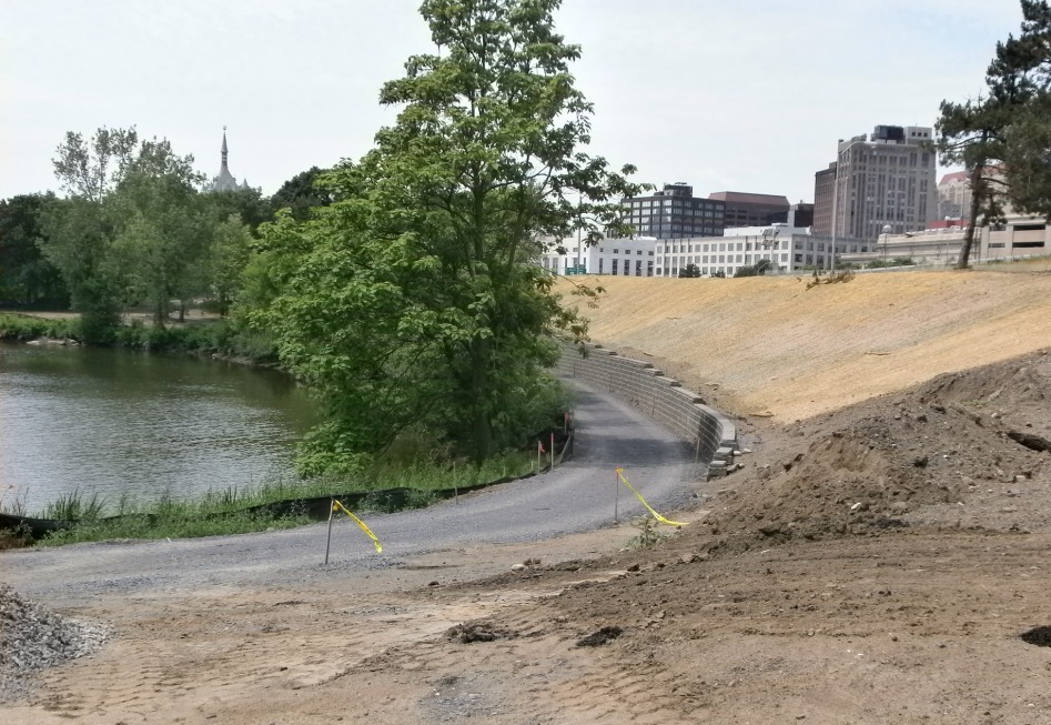
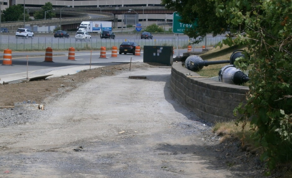
Multiuse Path Maintenance – the City of Albany Department of General Services was quite responsive to our recent (September) call for mowing and cleanup of the median/divider on the I-787 access/frontage road portion of the South End Connector. The city needs to ensure that this maintenance be a regular part of DGS’s role in the area. Glass in the cycle track will continue to plague people on bicycles.

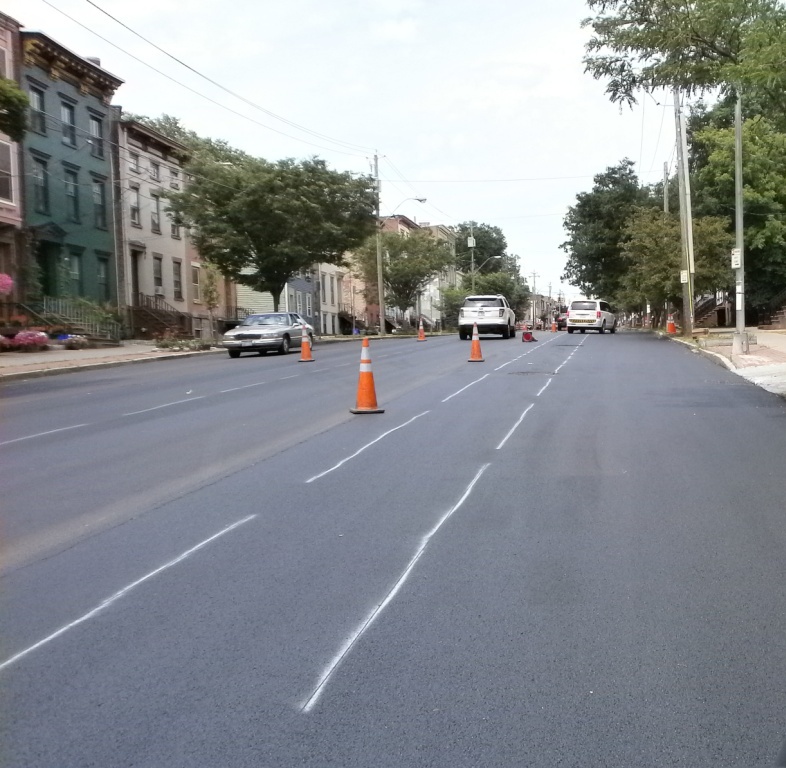
Signage, Lighting, and Striping at S. Pearl St.-South End Connector Intersection – There is a need for signage and re-striping of the crosswalks and possibly new lighting at the intersection of S. Pearl Street and the I-787 access/frontage road. This would alert people in cars who are making both left and right turns from S. Pearl onto the access road that bicyclists and pedestrians could be using the crosswalks. These are swooping turns that are, unfortunately, plentiful in the City of Albany. Motor vehicles traveling north on S. Pearl make the turn at excessive speed. It is awkward for bicyclists wanting to continue north on S. Pearl to see cars coming from the south. (That is, those who are not staying on the Connector beyond this intersection). Similarly, people on bicycles heading south on S. Pearl St. but wanting to enter the Connector going north (i.e., a left turn off S. Pearl St.) have difficulty making a safe turn. Pedestrians also have to look awkwardly to their left before stepping into the crosswalk.

Attention to this intersection (as well as Bassett St. and Broadway/Quay St.) is integral to making the Connector a community/local street asset and not merely a recreational, end-to-end experience. It is part of recognizing that the “South End” needs access to current and future bicycle facilities in the City of Albany.

Pedestrian And Cyclist Entrance/Exit at Bassett St. – To encourage safe access to the Connector and to promote it as a community resource, there needs to be an entrance/exit connecting Bassett St. and the South End Connector. The striped area could be modified easily for this purpose with only the addition of some striping (e.g., a green path) and a “no entry for motor vehicles” sign.

Enhanced Motor Vehicle Traffic Control at Broadway/Quay St. – This intersection has been a barrier for people on bicycles and people walking since its original construction. This long-standing problem predates the South End Connector by many years and was the site where a motor vehicle struck and killed cyclist Jose Perez.

Looking east toward the Hudson River, people in cars swoop off Broadway at high speeds to the right/south. When they make this right turn onto Broadway, they come up on the bicycle rider’s blind side. The only traffic control is a yield sign. This sign is ineffective since it is clear to a driver that there to no motor vehicle traffic to which to yield. At an absolute minimum, a stop sign should replace the yield sign. This alteration is a small task that could be done in an hour or two at minimal cost.

What is not so clear is that the South End Connector channels people on bicycles directly to a cross walk which is somewhat hidden from people in cars. While riders are scanning to their left and rear, they also have to be alert to motor vehicles coming north on Broadway to continue on Quay St. or Broadway into the city proper. Here we need more demonstrative traffic control.

++++++

Leave a comment

Filed under Activisim, Equity, safety, South End Bike Link, South End Bikeway Connector

South End Bikeway Connector Rumbles Along – Cont’d (11/10/19)

Here are today’s views of progress on the South End Bikeway Connector. The first shows a major step completed at the southern end of the Connector – curbing for the cycle track installed with the concrete curing under protective cover. Remaining steps include paving the bicycle area, installation of “protective ‘plastic’ bollards,” and striping.

OLYMPUS DIGITAL CAMERA

Next, a northerly view of Frontage Rd. along 1-787 showing the shoulder and one motor vehicle lane converted to a cycle track. The excavation is complete almost to Church/Vine Sts. Looking south from Church/Vine Sts. showing cut marks in the pavement and the progress on excavations from S. Pearl St. up to the construction vehicle in the distance.

OLYMPUS DIGITAL CAMERA

The soon-to-be linear park and off-road multiuse path under I-787 now being used as a construction staging areas – note piles of soil, rock, and granite curbing (to the left).

OLYMPUS DIGITAL CAMERA

A South End Bikeway Connector route description follows below. When completed, the SEBC will be the first Protected Bicycle Lanes in the City of Albany and the first bicycle lanes that actually connect up to other facilities – the Helderberg Hudson Rail Trail and the Mohawk-Hudson Bike-Hike Trail/Erie Canalway Trail/Empire State Trail. According to the City of Albany, construction on the SEBC will continue until the end of the 2019 construction season. With this additional 1.5 miles of bicycle lanes, Albany will have a total of 6 miles of bicycle lanes just in time for the 10 anniversary of the Albany Bicycle/Pedestrian Master Plan.

~ The South End Connector Bikeway Route Description ~

The bikeway begins at S. Pearl St./Old S. Pearl St. in the Helderberg Hudson Rail Trail trailhead and parking lot. Between Old S. Pearl St. and Mt. Hope Dr. and the Frontage Road (the I-787 northbound entry road), there will be a separated, on-street, two-way cycle track. (This two-way feature alleviates the need for people on bicycles to cross S. Pearl St.) The cycle track will continue onto the east/river side of the Frontage Rd. to Church St./Vine St. It will then briefly turn west before continuing on an off-road, 10-foot wide, multi-use trail and linear park underneath I-787 to Broadway and Quay St. To skirt the I-787 support structure, at the Church St./Bassett St. intersection the connector will be on-road until Rensselaer St. Here it again it will shift back off-road until the turn toward the Hudson River, the Slater and Dutch Apple mooring, and the Mohawk-Hudson Bike-Hike Trail/Albany Riverfront Park. To accommodate the connector’s path, Church St. from Rensselaer St. to Bassett St. will become a one-way southbound. Broadway currently consists of four travel lanes – two eastbound and two westbound. One lane on will be removed to construct the multi-use path on the south side of Broadway (where it passes under I-787), resulting in one westbound lane and two eastbound lanes.

Leave a comment

Filed under Albany County Rail Trail, Albany Riverfront Park, City Review, South End Bike Link

South End Ride-Walk Honoring Qazir Sutherland

This 3rd annual community event was held on Saturday, September 29 at the Ezra Prentice Homes on. Pearl St. This is one of the least safe streets in the City of Albany with a constant stream of high-speed cars and heavy trucks.

See Channel 10 Video here

There were opening remarks followed by a walk with about 25 participants and some Albany Police Department e-bicycle-mounted escorts along S. Pearl St. to the Helderberg Hudson Rail Trail. Other activities included DJ Supreme, fresh fruits, healthy living tips, a Y-infor table, and a Capital District Transportation Committee safety and trails exhibit. Walk partners included Qazir Sutherland’s Family, A Village, Capital District YMCA, Albany Housing Authority, the City of Albany, Albany County Department of Health, Albany Police Department, and Capital Roots with media support from the Albany Bicycle Coalition.

What better way to relax after a morning of community organizing than a cinnamon bun and coffee at the 3 Fish Café?

OLYMPUS DIGITAL CAMERA

Leave a comment

Filed under Activism, City Review, South End Bike Link

Protected Bicycle Lanes in Albany?

Protected Bicycle Lanes in Albany?

You saw it here first – under construction (photo #1). Hopefully those “Jersey Barriers” are an indication of the final Quay St. configuration (looking north just north of the USS Slater).

OLYMPUS DIGITAL CAMERA

#1 – PBL in Albany?

The Corning Riverfront Park Project will include the following according to the City of Albany:

  • Repaving and widening some areas of the multi-use path along the riverfront to accommodate two-way cycling as well as people walking.
  • Extending the multi-use path south to the Quay St. /Broadway intersection near the USS Slater (The Jose Perez Memorial Plaza) and north to Erie Blvd. (ed: Now if we can just build that South End Bikeway Link … )
  • Building a new two-way bicycle lane along the backside (west side) of the tidal ponds to bypass the amphitheater during events (photo #2 – tiptoe around the tidal pool looking south from near park HQ) .
  • OLYMPUS DIGITAL CAMERA

    #2 – Path for People on Bicycles West of the Main Park Area

  • Making the riverfront more accessible with new crosswalk signals at three intersections on Quay St. at Broadway, the Broadway Connector, and Water St.
  • Calming Quay Street to make it a “complete street.” Quay St. will go from two motor vehicle lanes to one to accommodate people on bicycles and people walking as well as motor vehicles (photo # 3 – Quay St. gets a shave – looking north from just past the pump station/former Aqua Duck HQ).

    OLYMPUS DIGITAL CAMERA

    #3 – Quay St. Gives Up a Motor Vehicle Lane to People

  • Adding nearly 50 parking spots on Quay St. to make it easier for people in cars to visit the riverfront.
  • Enhancing lighting along the new multi-use paths and along Quay St.
  • Providing benches, bicycle racks, and trashcans (ed.: recycling too?) along the paths.
  • Providing informational kiosks to promote Albany events and activities.
  • Adding trees to the park so that there will be more trees than before the project began.

Moving on (after a visit to the Corning Riverfront Park) – photo #4 shows markings for the return of Conventional Bicycle Lanes on the repaved Clinton Ave. Maybe the bicycle lanes can at least begin continued beyond Lexington to the intersection of Clinton and Central Aves. per the original plan.   As of 7/11, the lanes are re-marked from Ten Broeck to the western end of the re-paving project – you’ll notice the lane marking bicycles are now rider less.  Hmmmmm…

OLYMPUS DIGITAL CAMERA

Markings for Bicycle Lanes – looking west

Leave a comment

Filed under Corning Riverfront Park, protected bicycle lanes, South End Bike Link

Celebrating Trails in the Area – Not Once But Twice in the Same Issue of the Times Union!

South End Bikeway LinkCelebrating Trails in the Area – Not Once But Twice in the Same Issue of the Times Union!

Letters in the Albany Times Union – 4/17/16

#1 – Erin Walsh wrote about the Uncle Sam 3.1-mile paved rail-trail that runs through North Troy and Lansingburgh. She reported renewed interest in the trail, highlighting its value to the immediate community and the greater Capital Region. She noted that Capital Roots, Transport Troy, the National Park Service, Troy Bike Rescue, and Troy city have all taken an interest in the trail’s renewal.

You’ll have a chance to –

  • do trail cleanup on 4/23
  • join a community bike ride on 5/22
  • take a historical and nature walk on 6/4
  • join a community bike ride on 9/24 – the famous “Collar City Ramble”

Erin is an enthusiastic supporter of complete streets and other pro-pedestrian/cyclist initiatives in Troy and the Capital Region. Contact

++++++

#2 – For those who choose not to read the paper paper, you’ll miss the wonderful map of the South End Bikeway Link created by local artist and bon vivant, Frank Smith. I hope that you’ll soon be seeing this map elsewhere in the City of Albany.

In any case, the illustrative map highlights better than words the essence of this second letter – a call for immediate completion of a safe and protected connecting link between the Albany County Helderberg Hudson Rail Trail trailhead on S. Pearl St. and the \southern terminus of the Mohawk-Hudson Bike-Hike Trail at the Slater/Dutch Apple moorings.

Under city contract, Alta Planning + Design is conducting a feasibility/design study of this critical 1.3-mile link. Stay alert for meetings hosted by the city and Alta.

Just think – Voorheesville to Buffalo on an (almost) continuous trail!

Leave a comment

Filed under Activism, Albany County Rail Trail, Erie Canal Trail, protected bicycle lanes, South End Bike Link