Category Archives: Watervliet

Monkey Wards Way Now Open

Good News! – The Monkey Wards Way Connector linking Rt. 32/Broadway in Menands at the former Montgomery Ward retail store and warehouse and the Mohawk-Hudson Bike-Hike Trail just south of Troy is now open. This is a fine addition to the trail network. 

There is still a little work to be completed (e.g., control panels for the bicycle-pedestrian crossings at Broadway).

UPDATE – as the following two photos (taken 3-30-21) show, the combined bicycle-pedestrian traffic light controls are operational.

#1 – Controls for crossing the I-787 ramp
#2 – Control on west side of Broadway for crossing Broadway
Entry from Broadway (older photo)

Exiting onto Broadway – Bike Route #9

The Route

The RouteMonkey Wards Way is the only Mohawk-Hudson Bike-Hike Trail entry/exit between Albany’s Corning Riverfront Park and the Rt. 378 Bridge entrance to S. Troy and the only MHBHT access on the West side of the Hudson between Corning Riverfront Park at the Colonie St./boat launch area and 4th Street in Watervliet. The new Menands entrance is about 2.2 miles on Broadway from Watervliet’s 4th St. entrance and 3.1 miles on Broadway from Albany’s N. Lawrence St. Those going to or coming from a location on Broadway would have to choose an entry point – based on their traffic tolerance level and total distance.
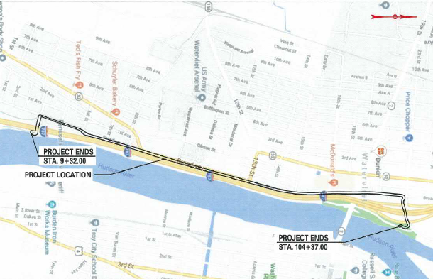
Area Map

Previously, once riders started out south from S. Troy or north from the Corning Riverfront Park on the Mohawk-Hudson Bike-Hike Trail, they committed to a 6-mile ride. This new Connector is the only modification to entry to the MHBHT since the July 2010 installation of the connection from the trail to S. Troy over the Rt. 378 Bridge (10 years ago!).

Connection Ramp to the Mohawk-Hudson Bike-Hike Trail
A Unicycle Maybe?
Looking Down onto the MHBHT and the Hudson River
Another View of the MHBHT – Note Walker

Sidebar – As an editorial note, this MHBHT/UST connection, as great as it is, was never 100 percent completed. First, there is no wayfinding features at either end so that only the “in-the-know” riders are aware of it. The Troy portion of the trail leaves people on bicycles with 2 options: dive into the “crazy-driver convention” at the Mill St./High/St./Burden Ave./Morrison Ave. traffic spaghetti bowl or ride the narrow, unkempt, bumpy sidewalk from the bridge to the traffic signal at Mill and Water. Not a feat for the faint of heart. One then makes a mad dash to the relative calm of Troy’s wonderful on- and off-street Uncle Sam Trail. For a review of the Uncle Sam Trail, go here – Uncle Sam Trail | Albany Bicycle Coalition On the plus side, the “serpentine” ramp connection between bridge sidewalk and the  trail was carefully engineered so that – although it looks steep – the majority of riders can climb it.

Potential Benefits – For some people, this new connector will be useful. Broadway is slowly being converted to semi-bicycle friendliness with a big gap between N. Pearl and downtown Albany (where there are zero facilities worth note). Northbound, there is a gap from Monkey Wards Way to Watervliet in which there are ample “low stress” side streets until one gets to the (off road) side path at 4th St. (See the CapitalNYBikeMap.) The traffic volume between the new Connector and Watervliet – with the exception of the Rt. 78 exit/entrance ramp area – is manageable for many riders, albeit in a low-low gear.

Westerly View – Note Wards (aka “Riverview Center”)
View from the Trail – Entrance Ramp to I-787 North and Exit Ramp from I-787 South – Noisy!

Monkey Wards Way offers options along that stretch as well as potential connection to other popular cycling routes such as the network of bicycle lanes on Van Rensselaer Blvd. and Northern Blvd. connecting the City of Albany and Albany Rural Cemetery. New explorers should note that most Van Rensselaer Blvd.-Broadway connections involve some notable hills.

Crossing I-787 – Looking South

Monkey Wards in the Background Looking North – Bike Lanes Approaching the Entrance to Monkey Wards Way

Maintenance – Maintenance will be a major concern, as the bottle throwers will continue their usual practice leaving a trail of potential flats behind them. The sections closest to the roadway will be the most troublesome as motor vehicle traffic sweeps trash into the path. The Rt. 378 path connecting the Uncle Sam Trail to the Mohawk-Hudson Bike-Hike Trail suffers from the same malady. Volunteers have occasionally taken to cleaning the area (as it seems to fall in one of those municipal border twilight zones that “is not my problem”). The 378 bridge substantial curbs lessen the sideward movement of road trash, unlike the Monkey Wards Way Bridge where the road way and trail are on one surface near and over the I-787 overpass (see photos). It will need frequent cleaning with non-standard-width equipment.

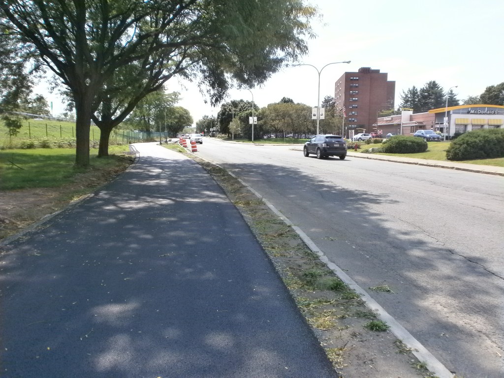
Construction 1 – Looking West with Monkey Wards to the Right on Broadway

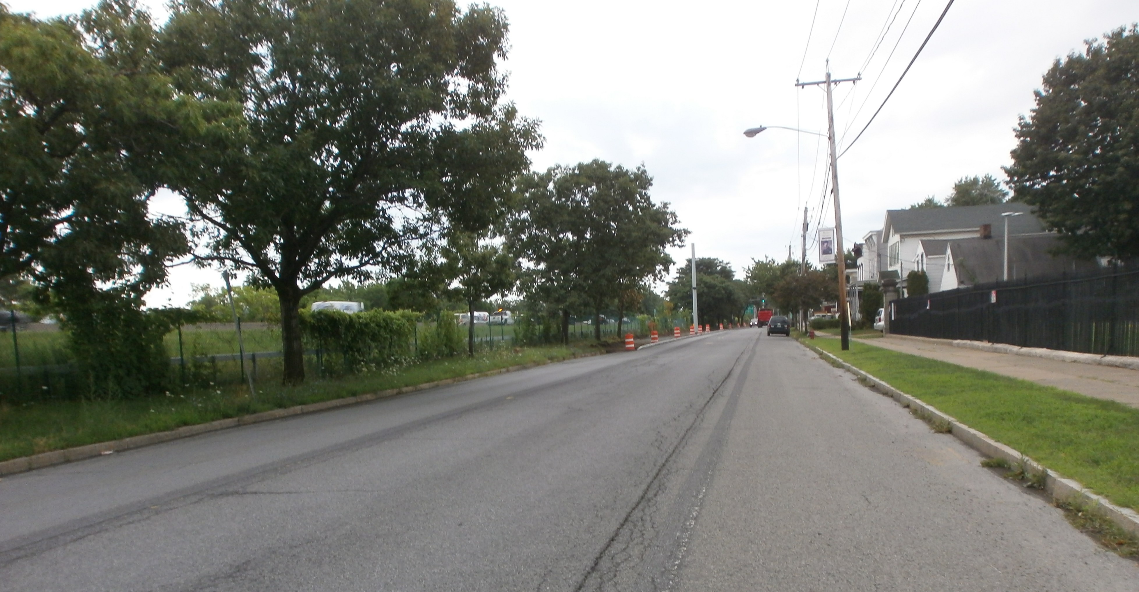
Construction 2 (looking east toward Troy)

Caveats – On the trail, there are two very sharp bends necessitated by the land available and the underpass at the southbound entrance ramp form Rt. 378 to I-87. There are “turn arrow” warning signs on both sides of the underpass, but it is sharp and fast and the tunnel is narrow. Riders will have to be cautious particularly when riding downhill.

The Tunnel – Slow Down!
Exiting the Tunnel Heading West Toward Wards and Broadway

Along Rt. 378 (esp. east bound), the trail is a noisy, noisy route with very high speed traffic just off one’s left shoulder and a skimpy, low-level guard rail.

Trail and Road on Same Surface Level – Low “Guard Rail”

People on bicycles entering the Monkey Wards Way from the south and those continuing north on Broadway will have to deal with a merging motor vehicle right turn lane and the bicycle lane that ends abruptly at the Connector entrance. It is not clear if there will be bicycle-level traffic control for people on bicycles coming south on Broadway and wanting to enter the Connector and the MHBHT. The bicycle lanes run south to the Broadway intersection with N. Pearl St.

Bike Lane-Motor Vehicle Turn Lane – Note Bike Lane Moves from Curb to Through Lane on the Left

Project Description – “Monkey Wards Way” is a playful name used until an official name is chosen. New York State Department of Transportation refers to the $7.9 million project as “Bicycle and Pedestrian Connection from Broadway to the Mohawk Hudson Bike Trail Along the Hudson River, Crossing Interstate 787 in the Village of Menands,” clearly not a catchy title to remember. See more on Department of Transportation’s project here –   NYSDOT | DYN_PROJECT_DETAILS

Conclusion – The new Monkey Wards Way presents an exciting option for riders going to or coming from various destinations. As the so-called warehouse district evolves and bicycle amenities on Broadway are expanded, the Connector suggests some interesting benefits. As always, people on bicycles will be the final judges on any the new bicycle travel option.

 ++++++

Leave a comment

Filed under Capital Trails-New York, Empire State Trail, Mohawk-Hudson Bike-Hike Trail, Trail Network, Watervliet

A Mystery at Schuyler Flatts

While snooping around the new cycle track in Watervliet (see Cycle Track in Watervliet – Update 9-8-20)  and winding back to Broadway/Rt 32, we came across a curious sign at the “dead end” at the southern terminus of Broadway. Clearly, this sign was placed with some intent. The google street view (image dated 2007) DOES NOT show the Erie Canalway Trail (ECT) and the Mohawk-Hudson Bike-Hike Trail (MHBHT) signs. The Village of Menands notes that “The Park includes a walking and jogging trail with access to the Hudson-Mohawk Bike Path.” Maybe there are yet more signs to be found in the park!

tumblr_pk0quzzhae1shobbq_500

The sign attests to continuation of both the Erie Canalway Trail and the Mohawk-Hudson Bike-Hike Trail. Why is it there? What was the plan? Where does it lead?

OLYMPUS DIGITAL CAMERA

Mystery Sign

Close Up – Mystery Sign

Option 1 – If south-bound riders on the Empire State Trail/Erie Canalway Trail/Mohawk-Hudson Bike-Hike Trail were unfamiliar with the connection of Broadway in Watervliet to the I-787 underpass leading to the MHBHT south to Albany or had just missed the turn, they could follow the sign into the Schuyler Flatts Cultural Park. The park shows clearly in the photograph. After some considerable confusion, the riders might have headed south on Broadway/Rt 32 searching for more MHBHT trail signage – a futile search indeed. It would be one group of confused cyclists! (If there is any signage for the MHBHT/Corning Riverfront Park on southbound Broadway, it is well hidden.) On the following map, use the dark blue trail and the red making on Broadway.

Schuyler Broadway Route Map

OPTION 2 – South-bound riders who wanted to get to Broadway/Rt 32 would find this sign very welcoming. Following it, they would avoid the traffic and intersections on Rt. 32 in Watervliet and would, instead, have a pleasant ride through the Schuyler Flatts Cultural Park. Following the paved path through the park, riders would exit onto Broadway at Village One Apartments/Schuyler Inn. While there is no active traffic control at this intersection, there is a well-marked pedestrian crossing with blinking caution lights. Riders then could proceed south on Broadway’s wide shoulders either to immediately leave for the “Albany Rural Cemetery Bypass” after 2/10 miles or to continue south on Broadway. (The “Albany Rural Cemetery Bypass” takes one to the bicycle lanes on Van Rensselaer Blvd. and Northern Blvd. and then to those on Clinton Ave.) This, of course, assumes that our riders are familiar with this option – leaving the MHBHT at 4th St. Those not aware of the mystery sign would have vended their way through city streets and could have reached the Schuyler Flatts Cultural Park via  2nd Ave. and entered the park on Schuyler Ln.

OPTION 3 – Really sophisticated riders who were planning on the “Albany Rural Cemetery Bypass” or who merely wanted to visit the park, would have left the MHBHT at 8th St. and then taken an immediate left turn onto 1st Ave or onto the unmarked road just past 1st Ave. to visit the Erie Canal Lower Side Cut Lock Park. Historically minded riders would have left the park on what is now an alley between 1st Ave./2nd Ave., and 3rd Ave. and followed the filled-in prism of the original Erie Canal to Schuyler Ln. and the Flatts. There are a couple uncertain spots on this route, but the perseverant rider will enjoy tracing the canal from the US Army Watervliet Arsenal to Schuyler Flatts Cultural Park and the preserved remnant of the original canal.

Option 4 – Riders who got to 4th St. at the I-787 underpass (leading to the Mohawk-Hudson Bike-Hike Trail south to Albany) could also brave the almost unride-able Schuyler Flatts Trail to the Flatts. They could hop the curb just after the left turn toward the Hudson River and follow the very scenic trail to its end at Schuyler Flatts Cultural Park. Sadly, this trail has been essentially abandoned with poor or misleading signage, broken pavement, and falling fencing. See the dark blue trail in the park and along the trail to 4th St. to follow the “Option 4” route.

Schuyler Flatts Route Map

More on the Schuyler Flatts Cultural ParkSchuyler Flatts Cultural Park – Located on Rt 32 between Menands and Watervliet in the Town of Colonie, this 12-acre park opened in fall 2002 on what was once the farm of the Schuyler family. The Schuyler farm was a staging area for revolutionary war encampments. Prior to this, it was the site of a Mohican summer encampment.

The area has great historical and archeological significance and is listed on the National Register of Historic Places. The Park includes a walking and jogging trail with access to the Hudson-Mohawk Bike Path. The park itself is a tranquil, wide-open green space for strolling and picnicking. A notable feature is a replica of a Dutch barn, testimony to the extensive (and lasting) presence of the settlers from the Netherlands. Of perhaps of more interest to the Erie Canalway Trail rider is the preserved prism of the original “Clinton’s Ditch” Erie Canal located just along Broadway. Tracing imaginary lines north and south from this point, will bring one to the canal’s former route along the Hudson-Mohawk Animal Shelter and then to “Canal Rd. S.” and Erie Blvd. in Albany. North will take you to the Watervliet alley and the Lower Side Cut Lock (see more in Option 3 above).

The Erie Canal was 363 miles long and included 18 aqueducts (to carry the canal over ravines, streams, and rivers) and 83 locks (with a rise of 568 feet from the Hudson River to Lake Erie). The cross-section or “prism” of the original Erie Canal was 4 feet deep, 40 feet wide at the water surface, and 28 feet at the bottom. It floated boats carrying 30 tons of freight. There was a 10-foot wide towpath along the bank of the canal for the horses (for packet boats) or mules (for cargo barges).

#####

Leave a comment

Filed under Comings and Goings, Erie Canal Trail, Local Bike Rides, Mohawk-Hudson Bike-Hike Trail, Trail Network, Watervliet

Cycle Track in Watervliet Update – 9-8-20

The good news is brief – the cycle track/multiuse path from 4th St at the terminus of the Mohawk-Hudson Bike-Hike Trail/I-787 Underpass to 23rd St. at Hudson Shores Park is mostly paved.

New Cycle Track

A few parts of the off-road portion still need final paving and the on-road portion on Broadway in front of the US Army Arsenal remains to be done. There is yet (of course) no signage, striping, etc.

The final configuration of the on-road portion passing in front of the Arsenal is not 100% clear but a guess is that it will skirt the curbing on the 787/river side with petrovehicle lanes moved toward the arsenal side. The photo looking south shows the off-road portion exiting onto/leaving from Broadway with the Arsenal in the background.

Entrance/Exit to On-Road Portion – Arsenal in Background

More background here – https://albanybicyclecoalition.com/2020/07/31/cycle-track-in-watervliet-coming-soon/ In this background post is the proposed route map. The north end of which is here on Google Maps https://www.google.com/maps/search/I+Got+Good+News+and+I+Go+Bad+News+-+Watervliet+Cycle+Track+Progress+(8-8-20)ter/@42.732763,-73.6976725,205m/data=!3m1!1e3  The cycle track doesn’t show yet of course.

This image has an empty alt attribute; its file name is watervliet-cycle-track-9-8-20-3.jpg
Cycle Track Exit from Hudson Shores Park – I-787 Exit ramp to Left

At the north terminus at Hudson Shores Park with the I-787 entrance ramp (on the west side of 787) has cars coming from both the west and east. The blue “jeep” is entering 787 with the cycle track paving leading across the ramp where it resumes. Note grey car entering from the other direction – scary!

The blue “jeep” is entering 787

The exit ramp onto 23 and Lower Hudson Ave. is brutal. ABC’s CapitalNYBikeMap will not put cyclists on Lower Hudson (to get to Green Isl., Troy, and the Empire State Trail continuation). Rather, it continues riders on Rt 32 to 25th St./Albany St. and then to Green Isl. and the Green Isl. Bridge/Troy. This is the established MHBHT route. See – https://www.alltrails.com/explore/trail/us/new-york/mohawk-hudson-bike-hike-trail?mobileMap=false&ref=sidebar-view-full-map  From the north end of the Watervliet cycle track to the Black Bridge in Cohoes is an “on-road” issue and thus under New York State Department of Transportation. The design is not yet available.

The cycle track begins on 4th St. after one exits the tunnel under I-787 at the trailhead of the Mohawk-Hudson Bike-Hike Trail. Note the brand new Empire State Trail sign!

Cycle Track at 4th St.

Leave a comment

Filed under Cycle Track, Empire State Trail, Watervliet

Cycle Track in Watervliet – Coming Soon!

The long awaited safe bikeway and multiuse path through Watervliet is coming to fruition. It originates at the park/trail head/parking lot terminus of the off-road portion of the Mohawk-Hudson Bike-Hike Trail and continues for about one and one-half miles to 23rd St. The “Watervliet Bike Path” will become shared lanes at 23rd St. for access to the Hudson Shores Park.

Map of the Project Area

Bike Way Map 2019

Those continuing to Green Isl. and the Erie CanalwayTrail/Empire State Trailwill continue on shared lanes on Broadway until 25th St. and then follow Albany St. to the Green Isl. Bridge to Troy or Hudson Ave. north – the current route of the Mohawk-Hudson Bike-Hike Trail.

Concept of Broadway Cycle TrackBrdway Near Arsenal EST

Broadway at 4th St. Exiting From the Park/Trail Head/Parking at Current Terminus of the Mohawk-Hudson Bike-Hike Trail

Brdwy & 4th MHBHT Watervliet 6-7-20

We were unsuccessful in getting from the City of Watervliet definitive information on the route and road treatments of the Empire State Trail/Watervliet Bike Path from Watervliet through to Green Isl. We are particularly interested in the treatment around the Rt. 2 Watervliet-Troy Bridge and the aforementioned Albany Ave./Hudson Ave./Green Isl. Bridge intersection. The New York State Department of Transportation 2018 “On-Road Routes Concept Plan” for the Empire State Trail sheds no light on this issue.

Progress Just North Of 4th St. – Note Passano Paints

More progress in Watervliet today

 James Roy Mills 1835 – Now Used By Passano Paints

OLYMPUS DIGITAL CAMERA

 Construction Ahead! (Heading South On Broadway)

OLYMPUS DIGITAL CAMERA

 Cycle Track Route between Motor Vehicle Lane And I-787 Fence (2 Views)

 Cycle Track Base I-787 Fence (North and South Views)

 View South with Arsenal Fence to the Right

OLYMPUS DIGITAL CAMERA

Heretofore, Broadway from the Mohawk-Hudson Bike-Hike Trail at 4th St. was one of the main barriers for less road-hardened riders going on to Troy, Cohoes, the Black Bridge, Champlain Canal Trail, Waterford, and the many sites along the way. The new bikeway is very impressive and will make the ride a wonderful experience. I-787 will be noisy but the bikeway will be safe and relaxing traffic wise.

 Empire State Trail staff graciously provided background resources and some of the information herein.

++++++

2 Comments

Filed under Capital Trails-New York, City Review, Cycle Track, Empire State Trail, Mohawk-Hudson Bike-Hike Trail, Watervliet