Category Archives: Mohawk-Hudson Bike-Hike Trail

Safe Connection of Mohawk-Hudson Bike-Hike Trail to Colonie & Points South

Concerned Town of Colonie residents and cycling/walking advocates are pushing for a multi-use path from the British American Blvd. bike lanes at Rt 7/Troy-Schenectady Road, across River Road to the Mohawk-Hudson Bike-Hike Trail (MHBHT). This path would provide a safe connection for bicycles and pedestrians and avoid the hazardous current route along Route 7 and Rosendale Road. It’s the missing link in the CapitalNYBikeMap UAlbany-to-Lions-Park route (see map below); it’s a strategic component of the Capital District Trails Plan’s “Shaker Trail” (page 33); and it will link directly to Colonie’s extensive Ann Lee/Shaker trail system and the airport. For a detailed analysis of why this path is vital, read David Pratt’s letter below, following the map.
See also: Times Union 02-12-22 and Save Colonie’s campaign

The Ask – To support this project, please write to or email both the Town of Colonie supervisor and the planning director at:

The Honorable Peter Crummey, Supervisor
Town of Colonie
Colonie Memorial Town Hall
534 New Loudon Rd.
Latham, NY 12110-0508 

coloniesupervisor@colonie.org

Sean M. Maguire, Director
Planning and Economic Development
Public Operations Center
347 Old Niskayuna Road
Latham, NY 12110-2290 

maguires@colonie.org

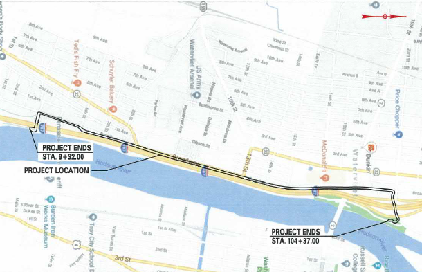
The UAlbany-to-Lions-Park route is a ten mile on- and off-road trail, providing a strategic north-south link across the I-90 / Central Ave. corridor. Commencing at Western Ave. / UAlbany, it eventually reaches the intersection of British American Blvd. and Route 7, as shown in blue on the map below. At that point the route becomes hazardous, as shown in red at the top. The proposed safe connection to MHBHT, under discussion, is shown in green.

Click the map to display it full-screen in a new tab.

Albany Colonie Connector

Google directions: Western Ave.-UAlbany to Six Mile Waterworks
Google directions: Six Mile Waterworks to British American Blvd

David Pratt is a Town of Colonie resident and regular user of the trail. Mr. Pratt presented a statement at the Town of Colonie Planning Board Meeting on January 25, 2022 the text of which follows below.

++++++ DAVID PRATT LETTER TEXT ++++++

Dear Town of Colonie Planning Board,  

My name is David Pratt. I would like to offer the following remarks. These remarks reflect my views only and not necessarily those of the multiple organizations that have signed the attached letter dated January 10, 2021.

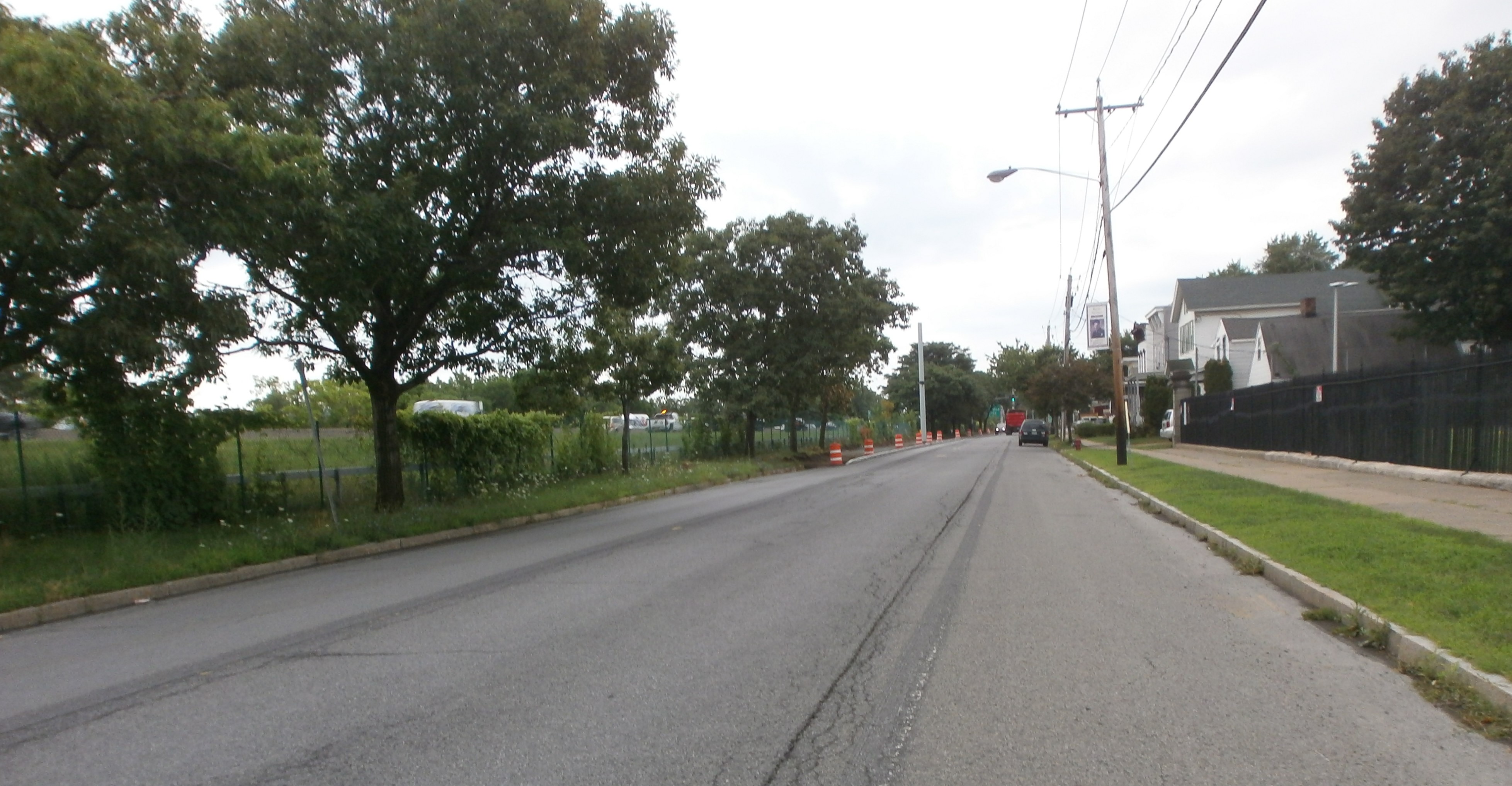
I live on River Road approximately 1 mile east of the Northview Development. The Empire State Bike Trail (a.k.a. Colonie bike path, multi-use trail, Mohawk-Hudson Trail, Mohawk River hike & bike trail etc.) is 65 yards from our front door. Like hundreds of other town of Colonie residents, I love this bike path. I am grateful for it each and every time I go out for a run, bike ride or walk my dog. I also firmly believe it adds to the resale value of my property.

I share many of the concerns of my neighbors on Buhrmaster Rd., River Road, and in the Northview development who stand in opposition to this proposal by Keeler Motor Car Company. I agree that a road connecting Keeler motors to River Road would be dangerous and detrimental. This should not be part of the approved plan. River Road has already effectively become “alternate Route 7.” There is heavy traffic every rush hour on this rural and scenic road. There is also rampant speeding and littering that accompanies this overuse. So while I oppose a vehicular connection between the Keeler complex and River Road, a connecting bike and pedestrian trail is an entirely different matter and I think it is a great idea that, by itself, will not unduly harm my neighbors.

The purpose of my attendance here tonight is to submit into the public record a letter jointly created by several local public interest groups. We who have signed this letter believe that any approval of this Keeler Motorcar Company proposal should only be approved by this Planning Board if it includes the creation of a bike path similar to the one graciously proposed by Keeler in their initial proposal.

This Board must weigh the benefits and costs of any development of the Keeler property amongst all the stakeholders. The stakeholders include Keeler, Northview and River Road neighbors, and most importantly, the Town of Colonie citizens who this Board proudly represents. Reasonable compromise is required of all parties. I am confident that a satisfactory compromise will be worked out by this Board.

Any reasonable compromise for the Keeler expansion should include a connector bike/walking trail. My neighbors are correct to raise concerns about traffic, congestion, runoff, noise, and even light pollution. Their concerns should be addressed and ameliorated to the greatest extent possible. However, I part with my neighbors in their reported opposition to the bike/pedestrian connector trail that was part of the initial development proposal. The neighbors’ concerns do NOT preclude the creation of a bike path. Compromise is possible here. Unfortunately, the specific objection to the bike path proposal is a textbook example of the NIMBY (not in my backyard) response. It pits the objection of a very small group of neighbors against the overall benefit to a public group hundreds of times larger. Mr. Neidl’s 6/2/21 letter disparages what he called “various special interest groups” who for years have advocated for this bike-path connector. Indeed, many thoughtful planning committees over the years have advocated for this connecting trail. Their interest was the overriding public good that this linkage would contribute, not selfish “special interests.” In truth, the only “special interest group” being represented here tonight is Mr. Neldi’s clients who wish to block a safe bike trail connector. I urge this group to reconsider their opposition and work with us for a reasonable compromise.

This bike trail is needed to safely link the existing Mohawk River bike path to the existing British American Blvd./Watervliet Shaker Road bike path. This current path provides access to the Airport, Shaker Heritage Society, and Anne Lee Pond. Additionally, newly constructed bike and pedestrian lanes along Albany Shaker Road stretch this path all the way to the Desmond hotel, not terribly far from the Colonie Town Library and even The Crossings Town Park. It would be great to link these public assets together. Can someone please remind me of the exact millions of taxpayer dollars spent on the very pretty but under-used path bridge that crosses Watervliet Shaker Road near the airport? Should this path dead end on the treacherous Troy Schenectady Road as it does now? How many millions of dollars were spent on the exciting new Empire State bike trail that now safely connects Buffalo and Albany? The distance between these two trail networks is only several hundred yards. How does it not make perfect sense to have a safe connection between these two public assets? There is an obvious synergy to leveraging these two expensive projects together for the benefit of all users. Most of these users are constituents of this very Board that I stand in front of.

Peter Crummey is beginning his term as Town Supervisor. One of the most popular planks that he ran on was his promise of enhancing the town of Colonie’s parks and recreational opportunities. In his January 1st interview with WAMC, he made special reference to improving the town’s recreational facilities and parks along the Mohawk River. This bike path connector would do exactly that and would be a win for him and for everybody who enjoy these bike paths.

This connector would also benefit businesses along Troy Schenectady Road. I can personally attest to the huge increase I have seen in the numbers of people bicycling between Buffalo and Albany and beyond. I see them every day simply by looking out my front window. I myself made this journey with some three hundred other cyclists in July. This connector would allow users of the bike path to more easily and safely access hotels, restaurants, fast food, the airport, and often needed bike repairs at The High Adventure Ski and Bike shop. I would love the opportunity to be able to safely ride to a restaurant for dinner or lunch. My first visit would personally be Innovo Kitchen, but there’s lots of good competition!

This connector will also enhance bicycle commuting to all the businesses along British American Blvd and beyond. It is a painless way of furthering the “green initiative” ideals that increasingly drive public policy. It would also offer additional opportunities for healthy outdoor recreation that we have all come to appreciate in this COVID pandemic.

To capitalize on the huge growth in bicycle tourism, we need a safe connector between the Albany International Airport and the newly created Empire State bike trail. My neighbor and Shaker High School classmate, Steve Iachetta, also lives directly on the bike path, not 30 yards off of it. He also has noted the huge increase in bicycle tourism along this trail. He also happens to be a planner with the Albany Airport Authority. He told me he receives calls from air travelers traveling with touring bikes requesting directions and the pathway between Albany Airport and the Empire State Trail. I will quote him directly: “I regretted having to advise them “there is no safe connection and you need a car or bus to transport your touring bike from the airport to the nearby state trail system.” Touring the trail by bike is a national vacation destination … both you and I see that with the increasing number of touring bicycles on the path.” 

The most important argument for this proposed bike path has to do with the personal safety of runners, walkers, cyclists, and dog walkers etc. who currently use these two respective un-linked trails. Again, these adults and children are some of the constituents of this Board. Right now, any connection between these two popular bike trails requires pedestrian or cycle access along the busy Troy-Schenectady Road. One must then bike, walk, or jog down one of three narrow, twisty, and hilly roads – Rosendale Rd., Buhrmaster Road, or Fort’s Ferry Road. One must then access the bike path along the river by crossing River Road at random and unmarked crossing locations. Can anyone argue that Route 7 or any of these three roads are safe for pedestrian or bicycle travel? Would you be comfortable with your children walking or bicycling on these roads? Any of us who drive these roads and attempt to safely pass cyclists and pedestrians are aware of the perils present on these roads that lead down the bike path. Yet the bike path is understandably a popular destination for runners, walkers, and pedestrians. And it will remain so. It is obvious that an off-road connector would be far safer and would enhance the quality of life for the capital District. Mr. Neidl’s 6/21/21 argument asserting that a bike path connector would be dangerous is clearly a spurious one.

I want to close on a very personal note. I am literally a lifelong resident of the Town of Colonie. I grew up in Loudonville. On Veterans Day in 1966, I was walking along Turner Lane in Loudonville with some other neighborhood children when my five-year-old brother was struck and killed by a car on the shoulder of Turner Lane. Now, decades later, I travel the Troy Schenectady Rd., River Road, Rosendale Road, Buhrmaster Road and especially Fort’s Ferry Road, multiple times each week and I dread coming upon another tragic accident. Over the intervening year’s countless children and adults have been killed or injured on our Town of Colonie roads. This proposed bike path would result in fewer pedestrians, runners, and bicyclists using these dangerous roads. It is very possible that a future life could even be saved by implementing this proposal. This alone is reason enough to create this short trail.

Sincerely,

David Pratt

++++++

The Gold Standard for Side Paths


Leave a comment

Filed under Albany-Colonie Connector, Capital Trails-New York, City Review, Mohawk-Hudson Bike-Hike Trail

Monkey Wards Way Now Open

Good News! – The Monkey Wards Way Connector linking Rt. 32/Broadway in Menands at the former Montgomery Ward retail store and warehouse and the Mohawk-Hudson Bike-Hike Trail just south of Troy is now open. This is a fine addition to the trail network. 

There is still a little work to be completed (e.g., control panels for the bicycle-pedestrian crossings at Broadway).

UPDATE – as the following two photos (taken 3-30-21) show, the combined bicycle-pedestrian traffic light controls are operational.

#1 – Controls for crossing the I-787 ramp
#2 – Control on west side of Broadway for crossing Broadway
Entry from Broadway (older photo)

Exiting onto Broadway – Bike Route #9

The Route

The RouteMonkey Wards Way is the only Mohawk-Hudson Bike-Hike Trail entry/exit between Albany’s Corning Riverfront Park and the Rt. 378 Bridge entrance to S. Troy and the only MHBHT access on the West side of the Hudson between Corning Riverfront Park at the Colonie St./boat launch area and 4th Street in Watervliet. The new Menands entrance is about 2.2 miles on Broadway from Watervliet’s 4th St. entrance and 3.1 miles on Broadway from Albany’s N. Lawrence St. Those going to or coming from a location on Broadway would have to choose an entry point – based on their traffic tolerance level and total distance.

Area Map

Previously, once riders started out south from S. Troy or north from the Corning Riverfront Park on the Mohawk-Hudson Bike-Hike Trail, they committed to a 6-mile ride. This new Connector is the only modification to entry to the MHBHT since the July 2010 installation of the connection from the trail to S. Troy over the Rt. 378 Bridge (10 years ago!).

Connection Ramp to the Mohawk-Hudson Bike-Hike Trail
A Unicycle Maybe?
Looking Down onto the MHBHT and the Hudson River
Another View of the MHBHT – Note Walker

Sidebar – As an editorial note, this MHBHT/UST connection, as great as it is, was never 100 percent completed. First, there is no wayfinding features at either end so that only the “in-the-know” riders are aware of it. The Troy portion of the trail leaves people on bicycles with 2 options: dive into the “crazy-driver convention” at the Mill St./High/St./Burden Ave./Morrison Ave. traffic spaghetti bowl or ride the narrow, unkempt, bumpy sidewalk from the bridge to the traffic signal at Mill and Water. Not a feat for the faint of heart. One then makes a mad dash to the relative calm of Troy’s wonderful on- and off-street Uncle Sam Trail. For a review of the Uncle Sam Trail, go here – Uncle Sam Trail | Albany Bicycle Coalition On the plus side, the “serpentine” ramp connection between bridge sidewalk and the  trail was carefully engineered so that – although it looks steep – the majority of riders can climb it.

Potential Benefits – For some people, this new connector will be useful. Broadway is slowly being converted to semi-bicycle friendliness with a big gap between N. Pearl and downtown Albany (where there are zero facilities worth note). Northbound, there is a gap from Monkey Wards Way to Watervliet in which there are ample “low stress” side streets until one gets to the (off road) side path at 4th St. (See the CapitalNYBikeMap.) The traffic volume between the new Connector and Watervliet – with the exception of the Rt. 78 exit/entrance ramp area – is manageable for many riders, albeit in a low-low gear.

Westerly View – Note Wards (aka “Riverview Center”)
View from the Trail – Entrance Ramp to I-787 North and Exit Ramp from I-787 South – Noisy!

Monkey Wards Way offers options along that stretch as well as potential connection to other popular cycling routes such as the network of bicycle lanes on Van Rensselaer Blvd. and Northern Blvd. connecting the City of Albany and Albany Rural Cemetery. New explorers should note that most Van Rensselaer Blvd.-Broadway connections involve some notable hills.

Crossing I-787 – Looking South

Monkey Wards in the Background Looking North – Bike Lanes Approaching the Entrance to Monkey Wards Way

Maintenance – Maintenance will be a major concern, as the bottle throwers will continue their usual practice leaving a trail of potential flats behind them. The sections closest to the roadway will be the most troublesome as motor vehicle traffic sweeps trash into the path. The Rt. 378 path connecting the Uncle Sam Trail to the Mohawk-Hudson Bike-Hike Trail suffers from the same malady. Volunteers have occasionally taken to cleaning the area (as it seems to fall in one of those municipal border twilight zones that “is not my problem”). The 378 bridge substantial curbs lessen the sideward movement of road trash, unlike the Monkey Wards Way Bridge where the road way and trail are on one surface near and over the I-787 overpass (see photos). It will need frequent cleaning with non-standard-width equipment.

Construction 1 – Looking West with Monkey Wards to the Right on Broadway

Construction 2 (looking east toward Troy)

Caveats – On the trail, there are two very sharp bends necessitated by the land available and the underpass at the southbound entrance ramp form Rt. 378 to I-87. There are “turn arrow” warning signs on both sides of the underpass, but it is sharp and fast and the tunnel is narrow. Riders will have to be cautious particularly when riding downhill.

The Tunnel – Slow Down!
Exiting the Tunnel Heading West Toward Wards and Broadway

Along Rt. 378 (esp. east bound), the trail is a noisy, noisy route with very high speed traffic just off one’s left shoulder and a skimpy, low-level guard rail.

Trail and Road on Same Surface Level – Low “Guard Rail”

People on bicycles entering the Monkey Wards Way from the south and those continuing north on Broadway will have to deal with a merging motor vehicle right turn lane and the bicycle lane that ends abruptly at the Connector entrance. It is not clear if there will be bicycle-level traffic control for people on bicycles coming south on Broadway and wanting to enter the Connector and the MHBHT. The bicycle lanes run south to the Broadway intersection with N. Pearl St.

Bike Lane-Motor Vehicle Turn Lane – Note Bike Lane Moves from Curb to Through Lane on the Left

Project Description – “Monkey Wards Way” is a playful name used until an official name is chosen. New York State Department of Transportation refers to the $7.9 million project as “Bicycle and Pedestrian Connection from Broadway to the Mohawk Hudson Bike Trail Along the Hudson River, Crossing Interstate 787 in the Village of Menands,” clearly not a catchy title to remember. See more on Department of Transportation’s project here –   NYSDOT | DYN_PROJECT_DETAILS

Conclusion – The new Monkey Wards Way presents an exciting option for riders going to or coming from various destinations. As the so-called warehouse district evolves and bicycle amenities on Broadway are expanded, the Connector suggests some interesting benefits. As always, people on bicycles will be the final judges on any the new bicycle travel option.

 ++++++

Leave a comment

Filed under Capital Trails-New York, Empire State Trail, Mohawk-Hudson Bike-Hike Trail, Trail Network, Watervliet

Rossi Junction – Honoring a Bicycling Hero

Rossi Junction – Honoring a Crucial Bicycling Activist – New York’s network of bike trails, paths, and routes that we enjoy today did not just materialize. In the 1990s laws were enacted that allowed the federal Highway Trust Fund to be used for bicycle and pedestrian needs. Afterwards, public investment in bicycle infrastructure exploded. No activist contributed more to New York State’s bicycle infrastructure than did Lou Rossi. He was a principal influence in opening the trust fund, and then became the driving force behind New York’s system of 21 signed Bike Routes. He wrote popular books on touring the state by bicycle. Moreover, as a founding member of NYBC, the New York State Bicycling Coalition, he formed an organization that vigorously lobbies State government to make cycling in New York friendlier and safer. You can learn more about Lou Rossi’s career and contributions to New York’s bike systems at this Internet link: https://tinyurl.com/RossiStory.

When Lou passed away in 2020, his colleagues at the State Department of Transportation decided to construct a memorial to honor his immense contribution to bicycling. Lou’s work exemplifies the best of Civil Service. Few in the broad bicycle community are aware of his contributions, but we all owe him immense gratitude. His colleagues hope to dedicate the memorial this spring. The memorial will be in Albany the intersection of the two longest Bike Routes – Bike Route 5 from Niagara Falls to Massachusetts and Bike Route 9 from Canada to New York City. ROSSI JUNCTION will denote the junction’s significance and have a rest area for local and touring cyclists’ enjoyment. If you want to know more about the memorial plans, go to this link: https://tinyurl.com/MemorialDescription.

Proposed Memorial Site at Corning Riverfront Park

We are raising funds to erect a suitable junction marker with interpretive plaques. If you enjoy New York State’s bike network or otherwise have benefited from Lou’s efforts we hope you will help.

If you would like to assist, please make a check out to the New York Bicycling Coalition and put “For Lou Rossi Memorial Fund” on the memo line. Mail it to New York Bicycling Coalition, PO Box 8868, Albany, NY 12208. Alternatively, go online at NYBC.net where you can use a credit card.

Thank You from the Committee for a Memorial to Lou Rossi:

Rich Brustman

Barry Hecht

Dick Maitino

Jeff Olson

Questions? You can email us at LouRossiMemorial@gmail.com or call at 518-461-8803

Leave a comment

Filed under Fundraising, Local Heros, Mohawk-Hudson Bike-Hike Trail

A Mystery at Schuyler Flatts

While snooping around the new cycle track in Watervliet (see Cycle Track in Watervliet – Update 9-8-20)  and winding back to Broadway/Rt 32, we came across a curious sign at the “dead end” at the southern terminus of Broadway. Clearly, this sign was placed with some intent. The google street view (image dated 2007) DOES NOT show the Erie Canalway Trail (ECT) and the Mohawk-Hudson Bike-Hike Trail (MHBHT) signs. The Village of Menands notes that “The Park includes a walking and jogging trail with access to the Hudson-Mohawk Bike Path.” Maybe there are yet more signs to be found in the park!

tumblr_pk0quzzhae1shobbq_500

The sign attests to continuation of both the Erie Canalway Trail and the Mohawk-Hudson Bike-Hike Trail. Why is it there? What was the plan? Where does it lead?

OLYMPUS DIGITAL CAMERA

Mystery Sign

Close Up – Mystery Sign

Option 1 – If south-bound riders on the Empire State Trail/Erie Canalway Trail/Mohawk-Hudson Bike-Hike Trail were unfamiliar with the connection of Broadway in Watervliet to the I-787 underpass leading to the MHBHT south to Albany or had just missed the turn, they could follow the sign into the Schuyler Flatts Cultural Park. The park shows clearly in the photograph. After some considerable confusion, the riders might have headed south on Broadway/Rt 32 searching for more MHBHT trail signage – a futile search indeed. It would be one group of confused cyclists! (If there is any signage for the MHBHT/Corning Riverfront Park on southbound Broadway, it is well hidden.) On the following map, use the dark blue trail and the red making on Broadway.

Schuyler Broadway Route Map

OPTION 2 – South-bound riders who wanted to get to Broadway/Rt 32 would find this sign very welcoming. Following it, they would avoid the traffic and intersections on Rt. 32 in Watervliet and would, instead, have a pleasant ride through the Schuyler Flatts Cultural Park. Following the paved path through the park, riders would exit onto Broadway at Village One Apartments/Schuyler Inn. While there is no active traffic control at this intersection, there is a well-marked pedestrian crossing with blinking caution lights. Riders then could proceed south on Broadway’s wide shoulders either to immediately leave for the “Albany Rural Cemetery Bypass” after 2/10 miles or to continue south on Broadway. (The “Albany Rural Cemetery Bypass” takes one to the bicycle lanes on Van Rensselaer Blvd. and Northern Blvd. and then to those on Clinton Ave.) This, of course, assumes that our riders are familiar with this option – leaving the MHBHT at 4th St. Those not aware of the mystery sign would have vended their way through city streets and could have reached the Schuyler Flatts Cultural Park via  2nd Ave. and entered the park on Schuyler Ln.

OPTION 3 – Really sophisticated riders who were planning on the “Albany Rural Cemetery Bypass” or who merely wanted to visit the park, would have left the MHBHT at 8th St. and then taken an immediate left turn onto 1st Ave or onto the unmarked road just past 1st Ave. to visit the Erie Canal Lower Side Cut Lock Park. Historically minded riders would have left the park on what is now an alley between 1st Ave./2nd Ave., and 3rd Ave. and followed the filled-in prism of the original Erie Canal to Schuyler Ln. and the Flatts. There are a couple uncertain spots on this route, but the perseverant rider will enjoy tracing the canal from the US Army Watervliet Arsenal to Schuyler Flatts Cultural Park and the preserved remnant of the original canal.

Option 4 – Riders who got to 4th St. at the I-787 underpass (leading to the Mohawk-Hudson Bike-Hike Trail south to Albany) could also brave the almost unride-able Schuyler Flatts Trail to the Flatts. They could hop the curb just after the left turn toward the Hudson River and follow the very scenic trail to its end at Schuyler Flatts Cultural Park. Sadly, this trail has been essentially abandoned with poor or misleading signage, broken pavement, and falling fencing. See the dark blue trail in the park and along the trail to 4th St. to follow the “Option 4” route.

Schuyler Flatts Route Map

More on the Schuyler Flatts Cultural ParkSchuyler Flatts Cultural Park – Located on Rt 32 between Menands and Watervliet in the Town of Colonie, this 12-acre park opened in fall 2002 on what was once the farm of the Schuyler family. The Schuyler farm was a staging area for revolutionary war encampments. Prior to this, it was the site of a Mohican summer encampment.

The area has great historical and archeological significance and is listed on the National Register of Historic Places. The Park includes a walking and jogging trail with access to the Hudson-Mohawk Bike Path. The park itself is a tranquil, wide-open green space for strolling and picnicking. A notable feature is a replica of a Dutch barn, testimony to the extensive (and lasting) presence of the settlers from the Netherlands. Of perhaps of more interest to the Erie Canalway Trail rider is the preserved prism of the original “Clinton’s Ditch” Erie Canal located just along Broadway. Tracing imaginary lines north and south from this point, will bring one to the canal’s former route along the Hudson-Mohawk Animal Shelter and then to “Canal Rd. S.” and Erie Blvd. in Albany. North will take you to the Watervliet alley and the Lower Side Cut Lock (see more in Option 3 above).

The Erie Canal was 363 miles long and included 18 aqueducts (to carry the canal over ravines, streams, and rivers) and 83 locks (with a rise of 568 feet from the Hudson River to Lake Erie). The cross-section or “prism” of the original Erie Canal was 4 feet deep, 40 feet wide at the water surface, and 28 feet at the bottom. It floated boats carrying 30 tons of freight. There was a 10-foot wide towpath along the bank of the canal for the horses (for packet boats) or mules (for cargo barges).

#####

Leave a comment

Filed under Comings and Goings, Erie Canal Trail, Local Bike Rides, Mohawk-Hudson Bike-Hike Trail, Trail Network, Watervliet

Cycle Track in Watervliet – Coming Soon!

The long awaited safe bikeway and multiuse path through Watervliet is coming to fruition. It originates at the park/trail head/parking lot terminus of the off-road portion of the Mohawk-Hudson Bike-Hike Trail and continues for about one and one-half miles to 23rd St. The “Watervliet Bike Path” will become shared lanes at 23rd St. for access to the Hudson Shores Park.

Map of the Project Area

Bike Way Map 2019

Those continuing to Green Isl. and the Erie CanalwayTrail/Empire State Trailwill continue on shared lanes on Broadway until 25th St. and then follow Albany St. to the Green Isl. Bridge to Troy or Hudson Ave. north – the current route of the Mohawk-Hudson Bike-Hike Trail.

Concept of Broadway Cycle TrackBrdway Near Arsenal EST

Broadway at 4th St. Exiting From the Park/Trail Head/Parking at Current Terminus of the Mohawk-Hudson Bike-Hike Trail

Brdwy & 4th MHBHT Watervliet 6-7-20

We were unsuccessful in getting from the City of Watervliet definitive information on the route and road treatments of the Empire State Trail/Watervliet Bike Path from Watervliet through to Green Isl. We are particularly interested in the treatment around the Rt. 2 Watervliet-Troy Bridge and the aforementioned Albany Ave./Hudson Ave./Green Isl. Bridge intersection. The New York State Department of Transportation 2018 “On-Road Routes Concept Plan” for the Empire State Trail sheds no light on this issue.

Progress Just North Of 4th St. – Note Passano Paints

More progress in Watervliet today

 James Roy Mills 1835 – Now Used By Passano Paints

OLYMPUS DIGITAL CAMERA

 Construction Ahead! (Heading South On Broadway)

OLYMPUS DIGITAL CAMERA

 Cycle Track Route between Motor Vehicle Lane And I-787 Fence (2 Views)

 Cycle Track Base I-787 Fence (North and South Views)

 View South with Arsenal Fence to the Right

OLYMPUS DIGITAL CAMERA

Heretofore, Broadway from the Mohawk-Hudson Bike-Hike Trail at 4th St. was one of the main barriers for less road-hardened riders going on to Troy, Cohoes, the Black Bridge, Champlain Canal Trail, Waterford, and the many sites along the way. The new bikeway is very impressive and will make the ride a wonderful experience. I-787 will be noisy but the bikeway will be safe and relaxing traffic wise.

 Empire State Trail staff graciously provided background resources and some of the information herein.

++++++

2 Comments

Filed under Capital Trails-New York, City Review, Cycle Track, Empire State Trail, Mohawk-Hudson Bike-Hike Trail, Watervliet