Category Archives: Corning Riverfront Park

Livingston Ave. Rail Road Bridge ~ Where Are We?

OLYMPUS DIGITAL CAMERA

Sadly, the 1902 Livingston Ave. Rail Road Bridge – the only east-west passenger RR crossing of the Hudson – seems to be nowhere as far as being replaced. The plan seems to be to let it fall in the river, or, as in the case of the Crown Point NY-Vermont Bridge, have it declared unusable so we can spend scrillions on “emergency” replacement. Then everyone can pat himself or herself on the back for having “saved the day.”

People on bicycles who want a water-level route across the river to access Rensselaer or Albany are counting on Amtrak/Conrail/NYSDOT et al. to reinstall a pedestrian/bicycle patch on the new bridge.

To learn more, go to the Livingston Ave. Rail Road Bridge Coalition site – http://livingstonavebridge.com/home/where-have-you-been/

OLYMPUS DIGITAL CAMERA

Leave a comment

Filed under Activisim, Corning Riverfront Park, Livingston Ave RR Bridge, Mohawk-Hudson Bike-Hike Trail

Whoa! – Floods on the Mohawk-Hudson Bike-Hike Trail

Whoa! – Floods on the Mohawk-Hudson Bike-Hike Trail

ACP-MHBHT 4-5-17 (5)

Alert rider Brent reports that the Corning Riverfront Park bikeway and the Mohawk-Hudson Bike-Hike Trail are partially flooded. In some places, water was up to the wheel hubs. It’s +12 inches of flooding and impassable.

So spread the word on trail flooding taking place on the MHBHT and on the new Corning Riverfront Park Trail.

Looking ahead based on past similar events, when the water recedes there will be slippery/muddy spots and, after drying out, heavy dust – which is likely toxic.

(May is coming!)

ACP-MHBHT 4-5-17 (2)ACP-MHBHT 4-5-17 (7)

ACP-MHBHT 4-5-17 (1)

ACP-MHBHT 4-5-17 (6)ACP-MHBHT 4-5-17 (8)

2 Comments

Filed under Corning Riverfront Park, Mohawk-Hudson Bike-Hike Trail

SEBL Funded! Construction of the City of Albany South End Bikeway

Alert Cyclist Mark informs us as follows:

The State’s Regional Economic Development Council Awards for 2016 includes (page 81, middle of the page, project #627184) $325,000 toward design and construction of the South End Bikeway Link. It is described as a “two-way, Separated Bike Lane, also known as a cycle track, extending along the east (ED: river/port/RR) side of South Pearl Street where sidewalks exist.” The Times Union story is here.

The full project (with editorial corrections) is as follows: The City of Albany will design and construct the South End Multi-Use Trail, located in the South Waterfront District, that will link the Albany County Helderberg Hudson Rail Trail to the Mohawk-Hudson Hike-Bike Trail/Erie Canalway Trail, filling a gap in a more than 360-mile multi-use trail network. The proposed treatment is a two-way, Separated Bike Lane, also known as a cycle track, extending along the east side of South Pearl Street where sidewalks exist.

The funding of the South End Bikeway Link is perfectly timed with the pending completion of the Corning Riverfront Park Protected Bicycle Lanes and the other amenities as well as with completion of ABC’s BikeAlbanyMap. The three projects now provide people on bicycles with many options for safely and efficiently transporting themselves around the city and region.

tumblr_og9qebuctg1uzhyk9o1_540

OLYMPUS DIGITAL CAMERA

Building the ACHHRT


1 Comment

Filed under Albany County Rail Trail, Bike Lanes, Corning Riverfront Park, Erie Canal Trail

Jewel in the Crown?

***UPDATE***

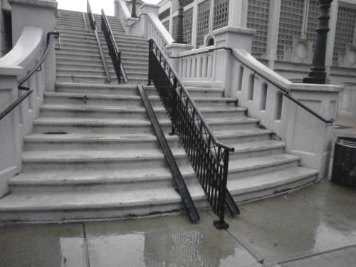
Alert cyclist Brent noted that the bicycle ramps have had a entry ramp added – see picture: bike-ski-11-28-16-crop


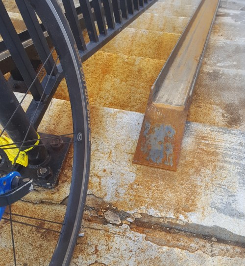
Back-story – The revitalization of the Corning Riverfront Park proceeds apace. The “finishing touches” are nearing completion. The new “green path” is open or will be soon so that people on bicycles can ride from the Slater to the Barge/DGS building without having to navigate amongst the walkers, joggers, and strollers. At Colonie/Water Sts., a second segment helps riders get clear of the Corning Riverfront Park and across the I-787 exit ramp. [Ed: Be careful here!]

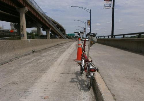
Alert cyclist Brent reported that bicycle ramps are installed on the stairs leading to and from the Corning Riverfront Park over the bridge that crosses I-787 at Pine St. on Broadway. Now, instead of carrying one’s bicycle up or down the stairs, one can walk it up or down the ramp. As a cautionary note, lean your bicycle away from the hand railing to prevent interference with the pedals.

OLYMPUS DIGITAL CAMERA

The ramps help those whose bicycle weight or degree of fitness makes climbing/descending the stairs a chore. In addition, those who want to enter the Corning Riverfront Park WITHOUT risking the Jose Perez Memorial Plaza (at the Slater entrance) or the I-787 off ramp (at Colonie St.) or who are in midtown, can now use the pedestrian bridge (with ramps) as a good alternative. Notabley, people on bicycles can access the Corning Riverfront Park from either end by using the BikeAlbanyMap. OLYMPUS DIGITAL CAMERA

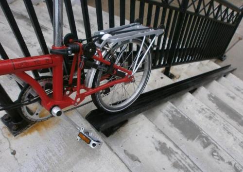
The ramps are a good idea. Nevertheless, check the motorized “bicycle lift” in Trondheim – a good idea for the  State or Morton St. hills?

1 Comment

Filed under Bike Lanes, Bike Tech, Corning Riverfront Park, protected bicycle lanes

Protected Bicycle Lanes in Albany?

Protected Bicycle Lanes in Albany?

You saw it here first – under construction (photo #1). Hopefully those “Jersey Barriers” are an indication of the final Quay St. configuration (looking north just north of the USS Slater).

OLYMPUS DIGITAL CAMERA

#1 – PBL in Albany?

The Corning Riverfront Park Project will include the following according to the City of Albany:

  • Repaving and widening some areas of the multi-use path along the riverfront to accommodate two-way cycling as well as people walking.
  • Extending the multi-use path south to the Quay St. /Broadway intersection near the USS Slater (The Jose Perez Memorial Plaza) and north to Erie Blvd. (ed: Now if we can just build that South End Bikeway Link … )
  • Building a new two-way bicycle lane along the backside (west side) of the tidal ponds to bypass the amphitheater during events (photo #2 – tiptoe around the tidal pool looking south from near park HQ) .
  • OLYMPUS DIGITAL CAMERA

    #2 – Path for People on Bicycles West of the Main Park Area

  • Making the riverfront more accessible with new crosswalk signals at three intersections on Quay St. at Broadway, the Broadway Connector, and Water St.
  • Calming Quay Street to make it a “complete street.” Quay St. will go from two motor vehicle lanes to one to accommodate people on bicycles and people walking as well as motor vehicles (photo # 3 – Quay St. gets a shave – looking north from just past the pump station/former Aqua Duck HQ).

    OLYMPUS DIGITAL CAMERA

    #3 – Quay St. Gives Up a Motor Vehicle Lane to People

  • Adding nearly 50 parking spots on Quay St. to make it easier for people in cars to visit the riverfront.
  • Enhancing lighting along the new multi-use paths and along Quay St.
  • Providing benches, bicycle racks, and trashcans (ed.: recycling too?) along the paths.
  • Providing informational kiosks to promote Albany events and activities.
  • Adding trees to the park so that there will be more trees than before the project began.

Moving on (after a visit to the Corning Riverfront Park) – photo #4 shows markings for the return of Conventional Bicycle Lanes on the repaved Clinton Ave. Maybe the bicycle lanes can at least begin continued beyond Lexington to the intersection of Clinton and Central Aves. per the original plan.   As of 7/11, the lanes are re-marked from Ten Broeck to the western end of the re-paving project – you’ll notice the lane marking bicycles are now rider less.  Hmmmmm…

OLYMPUS DIGITAL CAMERA

Markings for Bicycle Lanes – looking west

Leave a comment

Filed under Corning Riverfront Park, protected bicycle lanes, South End Bike Link