Category Archives: Fuller Rd.

News relating to the Fuller Rd./Washington Ave. Construction Project

By Their Fruits Ye Thou Shalt Know Them or By Their Business Cards You Can Figure It Out –

As with many organizations, the Albany Bicycle Coalition has evolved its public presentation over the years. This is particularly true in the case of its business card.

The first card was quite abstract and contained little information other than a website and a Google phone number. It was designed by Bob who was also instrumental in getting the Albany bicycle coalition’s designation as a not-for-profit corporation. It had a hint of the logo that the organization later adopted.

Was it a business card or a wine coaster? The second card was quite innovative stylistically. It was created by Marie. Not only was the card a radical departure from the traditional approach but it also introduced the ABC logo which has become a permanent part of the organization’s public image. Marie was a graphic designer with a multiplicity of talents including owning and piloting a cruise ship styled after a Mississippi River paddle boat. They “Caldwell Bell” cruises on the Hudson River and the Champlain Canal with a home port of Schuylerville. Marie took a quite different reproach with a circular. This card had quite a bit of information about ABC. Marie was also the designer and producer of the original run of ABC t-shirts which she did pro bono. But will it fit in a Rolodex? (What’s a “Rolodex?”)

The most recent 2022 card is a traditional approach to business card. It has a lot of information about the organization and will help the user to explore not only the organization but it’s signature product, CapitalNYBikeMap. This card was designed by Glenn

PS – If you want a supply of ABC business cards, send an email to: Albany Bicycle Coalition <a href="http://Albany Bicycle Coalition <albanybicyclecoalition@yahoo.com>

Leave a comment

Filed under Feature, Fuller Rd.

Albany – Colonie Connector

The Colonie Village Connector is an element in the overall Albany-Colonie Connector. The following letter calls for the Village of Colonie to install bicycle lanes through its industrial park to connect Rapp Rd./Lincoln Ave. to the Central Ave. to Locust Pk. And other routes leading to the Mohawk-Hudson Bike-Hike Trail near RT. 7. See also – https://albanybicyclecoalition.com/2018/09/03/washington-ave-flyover-a-call-for-change/

++++LETTER++++

September 13, 2018 – RE: Colonie Village Connector

 Hon. Frank Leak, Mayor, Village of Colonie, 2 Thunder Road, Albany, NY 12205

Dear Mayor Leak:

This is to ask your leadership in creating a new bicycle-friendly route through the Village of Colonie – the Colonie Village Connector. We in the Albany Bicycle Coalition believe that this will help establish the Village as a sea of calm in a motor vehicle dominated area and provide substantial benefits to your walking and riding citizens – as well as those people in cars who would appreciate “calmed traffic.”

Our proposal is that the Village of Colonie build on the routes leading to and from it by the simple and inexpensive installation of one mile of bicycle lanes on the Petra Lane/Walker Way/Jupiter Lane Clark Industrial park corridor. Such an improvement will connect the Village to the University at Albany, to Guilderland and to the City of Albany via the proposed “Industrial Park Bikeway” consisting of Rapp Rd., the Six-Mile Trail, the Washington Ave. Corridor and the University at Albany Purple Path. It will also go north and west via Locust Park and Hunting streets to Sand Creek Rd. and the Shaker Multiuse Path leading past the airport to Route 7 and the Mohawk-Hudson Bike-Hike Trail/Empire State Trail. (An annotated list of the connecting routes is enclosed.)

A major safety benefit that would derive from the proposed Colonie Village Connector would be diverting bicycle traffic from the Central Ave./I-87/Wolf Rd. danger zone.

John Gillivan, village resident and bicycle advocate, obtained a grant to conduct a family bicycle rodeo in Thunder Park with a “pop-up” bicycle lane on Locust Park – one of the linking roads. This event demonstrated to enthusiasm and support that would derive from the Village of Colonie expanding its bicycle facilities.

Mayor Leak, while we recognize that segments of the proposed linkage have a project life of their own and that some segments – notably Rapp Rd. – are barely rideable, action by you and the Village of Colonie to install bicycle lanes on Petra/Walker/Jupiter may wellPeds Rapp Rd 9-1-18 (1).JPG encourage other officials to take steps to hasten improvement of these interconnecting segments.

Sincerely yours, Albany Bicycle Coalition, Inc.

cc: Edward Sim, Deputy Mayor, Frank Prevratil, Traffic Committee

++++ATTACHMENT++++

~ Trail and Road Elements in the Colonie Village Connector ~

(Annotated list of the connecting routes) – September 13, 2018

Industrial Park Bikeway – Addition of bicycle lanes on Petra Ln., Walker Way, and Jupiter Ln. (1.1 miles). Map – https://www.google.com/maps/dir/42.7093357,-73.8412039/42.7201327,-73.8357653/@42.7114468,-73.8381526,1466m/data=!3m1!1e3!4m2!4m1!3e1

Rapp Road – The section from the railroad tracks at Petra Ln. and Lincoln Ave. to the Six-Mile Trail (0.7 miles). This road is narrow, winding and in terrible condition with no accommodation for people walking or riding. The Albany Bicycle Coalition has a separate campaign to address this situation.

OLYMPUS DIGITAL CAMERA

Six-Mile Trail – The Six-Mile Trail joins Fuller Rd. at the roundabouts to Rapp Rd. at the Solid Waste Management Facility. This multiuse path falls under the Albany Department of Water and Water Supply. The Albany Bicycle Coalition has worked successfully with that water department and with Albany’s Department of General Services to have signs installed at the ends of the multiuse path to guide route access (in process – 1.3 miles).

Washington Avenue – Patroon Creek Corridor – This project covers Washington Ave., between Brevator St. and the Eastbound I-90 on-ramp (Exit 2), across from the University at Albany. This is a major arterial connecting residential and commercial properties. Modifications will improve safety and reduce roadway conflicts to complement the reduced 30-mph speed limit. Project Updates – https://washingtonpatrooncorridor.weebly.com/project-updates.html , Map – https://www.google.com/maps/d/viewer?mid=1bjlrEiOrM9sEeYbUpRfM37Dv1bNWS4KQ&ll=42.68690102151503%2C-73.81502894183347&z=14 , and specifications on the study: https://washingtonpatrooncorridor.weebly.com/ The Albany Bicycle Coalition has a separate campaign to address the “all cars-all the time” road design on the Washington Ave. Extension Flyover and the traffic circles on Fuller Rd. See – https://albanybicyclecoalition.com/2018/09/03/washington-ave-flyover-a-call-for-change/

Purple Path – As original envisioned by the late University at Albany President, Kermit Hall, the “Purple Path” would connect the University to the surrounding communities. Currently, this multiuse path falls somewhat short of this goal in that it is primarily an on-campus facility with the connections either in rudimentary form or nonexistent. The Albany Bicycle Coalition will initiate discussions with the university to seek resolution of these conditions. See – whttps://www.albany.edu/campusrecreation/pedestrian_bikepaths.php

Locust Park and the Short Section of Hunting Rd. Heading North to Sand Creek that Begins at the Bridle Path – Suburban style streets on which appropriate signage and pavement markings are need to provide safe passage for people on bicycles and on foot/wheelchairs/etc. Map – https://www.google.com/maps/dir/42.7209216,-73.8344883/42.7399445,-73.8190363/@42.7266339,-73.8260425,1367m/data=!3m1!1e3!4m2!4m1!3e1

Sand Creek Road – Major suburban arteirlal. No plans at present to add bicycle- or pedestrian-friendly facilities.

Shaker Multiuse Path – Flat, 2.4-mile multiuse path (paved – 1.3 miles, paved with bicycle lane – 1.1 miles). Starting from Troy-Schenectady Rd. (Route 7), a multiuse path runs south along British American Blvd. through an office park to a bridge crossing Rt. 155. The trail follows Rt. 155 south and then continues on road on Airline Dr. and S. Family Rd. to Sand Creek Rd., and then to Hunting St. and Locust Park. Description – http://bikeitorhikeit.org/shaker_multi_use_trail.htm

Mohawk-Hudson Bike-Hike Trail/Empire State Trail – The Mohawk-Hudson Bike-Hike Trail is the Capital Regions premier trail running from the Albany Riverfront Park to Rotterdam Junction. It will be part of the Empire State Trail. See – https://www.alltrails.com/trail/us/new-york/mohawk-hudson-bike-hike-trail

++++END++++


Leave a comment

Filed under Activisim, Albany-Colonie Connector, Fuller Rd.

Washington Ave. Flyover – A Call for Change

Washington Ave. Flyover – A Call for Change – In fall 2012, the long awaited “Flyover” to route through motor vehicle traffic from Washington Ave. to the Washington Ave. Extension was completed. This and the accompanying series of traffic circles on Fuller Rd. were clearly designed under an “all cars-all the time” philosophy. These means that people on bicycles who want to travel on Washington Ave. and its Extension, on Fuller Rd., on the University at Albany’s “purple path,” and on the Six-Mile Trail must be in the Advanced/Experienced “Strong and Fearless” or “Enthused and confident” 1 percent category.

The following letter calls for the New York State Department of Transportation to revisit this area and to modify it to accommodate people on bicycles.

Here are some earlier rider assessments.

++++++ LETTER ++++++

Albany Bicycle Coalition, Inc.

September 4, 2018

RE: Washington Ave. Flyover at Fuller Rd.

Sam Zhou, PE – Director
Region One – NYS Department of Transportation
50 Wolf Road
Albany, NY 12232

Dear Mr. Zhou:

This is to seek your assistance in clarifying safety concerns of the Albany Bicycle Coalition and of people on bicycles who use Washington Ave., Washington Ave. Extension, and Fuller Rd.

Because of our advocacy role in the region, we receive questions and comments about riding conditions. One common area of concern is navigation of the Fuller Rd. traffic circles, the Fuller Rd./Washington Ave. intersections, the Flyover, and bicycle travel on Washington Ave. Extension. As you are aware, fear of riding in traffic is the single, major impediment to bicycle travel. This is nowhere more apparent than in those spaces where motor vehicle movement was the paramount design feature.
In response to these concerns, we formed a study group to develop questions and recommendations about these specific roadways. We are at the point where we need advice from you or members of your staff on what are feasible treatments for this Washington Ave.-Fuller Rd. area.

I am asking that you arrange for our group to meet with you or staff for a learning session where we can articulate our concerns and our ideas. I am enclosing some specific ideas that result from our site visits and deliberations. Because several of our members work during the day, it would be helpful to have such a meeting at the end of or after the businesses day. This meeting could be augmented by site visit(s).

We look forward to hearing from you.

++++++ Attachment ++++++

ALBANY BICYCLE COALITION, INC.

SPECIFIC RECOMMENDATIONS
ON FULLER RD./WASHINGTON AVE. FLYOVER
September 2018

  1. Bicycles Ahead Signage – Place several signs near the merge areas on both Fuller Rd. and Washington Ave. (Share the Road, Bicycles In Lane, etc.). Of particular emphasis is the on ramp to westbound Washington Ave. Extension from southbound Fuller Rd.
  2. Bicycle Lane Markings – Install conventional bicycle lane pavement markings on the Washington Ave. “flyover” shoulders to designate clearly where the people on bicycles should be riding. These markings will instruct both cyclists and people in cars.
  3. Bicycle Lane – Install “Bicycle Lane” signs near and at both entrances to the Flyover.
  4. Activation Alert – Install bicycle-activated sensors to illuminate a bicycle symbol sign on the Fuller Rd. exit onto westbound Washington Ave. These will alert motorists when cyclists are present. Bicycles would activate these as they pass over the correct place on the shoulder (bicycle lane) without stopping. (A less effective alternative is MUTCD-compliant flashing LED edge-light signs with high-intensity LEDs.)
  5. Intersection Crossing Pavement Marking on Westbound Washington Ave. – Install crossing markings (e.g., dotted green and white) in the median to guide people on bicycles from the proposed bicycle lane on westbound Washington Ave. to the proper lane to continue west on Washington Ave. Extension. This will (1) alert people in cars to the presence of bicycles and (2) guide cyclists away from the tail of the merge lane (where they would risk conflicts with both the through motor vehicles and the merging motor vehicles).
  6. Shared Lanes Markings – Install Shared Lanes pavement markings on all lanes leading to and from the flyover.
  7. Walk Your Bicycle Assist – Install enhanced walking instructions for those people on bicycles who prefer not to navigate by bicycle the multiple traffic circles to access the Six-Mile Trail, Washington Ave., the University at Albany campus, or Fuller Rd. Ensure continued diligence to maintain and clean the sidewalks, curb cuts, and pavement markings/signage.

4 Comments

Filed under Activisim, Albany-Colonie Connector, Fuller Rd., NYS DOT, Washington Ave.

6-Mile Park Trail – Signage

Albany Bicycle Coalition, Inc.
127 S. Pine Ave.
Albany, NY 12208
April 9, 2018

RE: Signage at the 6-Mile Park Multiuse Path

Daniel Mirabile,Commissioner, Department of General Services

Joseph E. Coffey, Jr., PE, Commissioner, Albany Department of Water and Water Supply

Dear Commissioners:

This is to ask that you coordinate on installing wayfinding signage at the two entrances to the “6-Mile Park Multiuse Path.”

The multiuse path/bikeway – connecting the 6-Mile Park with Rapp Rd. at the Solid Waste Management Facility – needs signage to direct users to the path. The route is for recreation by people on bicycles and walking. It is a critical “low stress” bicycle connector between the city and Central Ave. with connections to Sand Creek Rd. and beyond. This avoids the death-defying portion of Central Ave. around I-87 and the shopping mall complex on Central Ave./Wolf Rd. We also suggest adding signage to direct both walkers and cyclists to the University at Albany “Purple Path” and the connection to it along the “nano complex” on Fuller Rd.

The Capital District Transportation Committee staff can advise on the style of signage that will be compatible with the overall trail network in the four-county region as well as with the developing Empire State Trail. You could do the requested work with in-house resources on an “as-time-permits” basis.

We in the Albany Bicycle Coalition would be pleased to meet with you or staff to include site visits to explain better our objectives for enhancing the value of the 6-Mile Multiuse Path.

Special Notes:

  • DGS: In addition to wayfinding signage, we suggest warning signs on both the trail and the Rapp Rd. facility entrance to alert people to the heavy truck traffic.
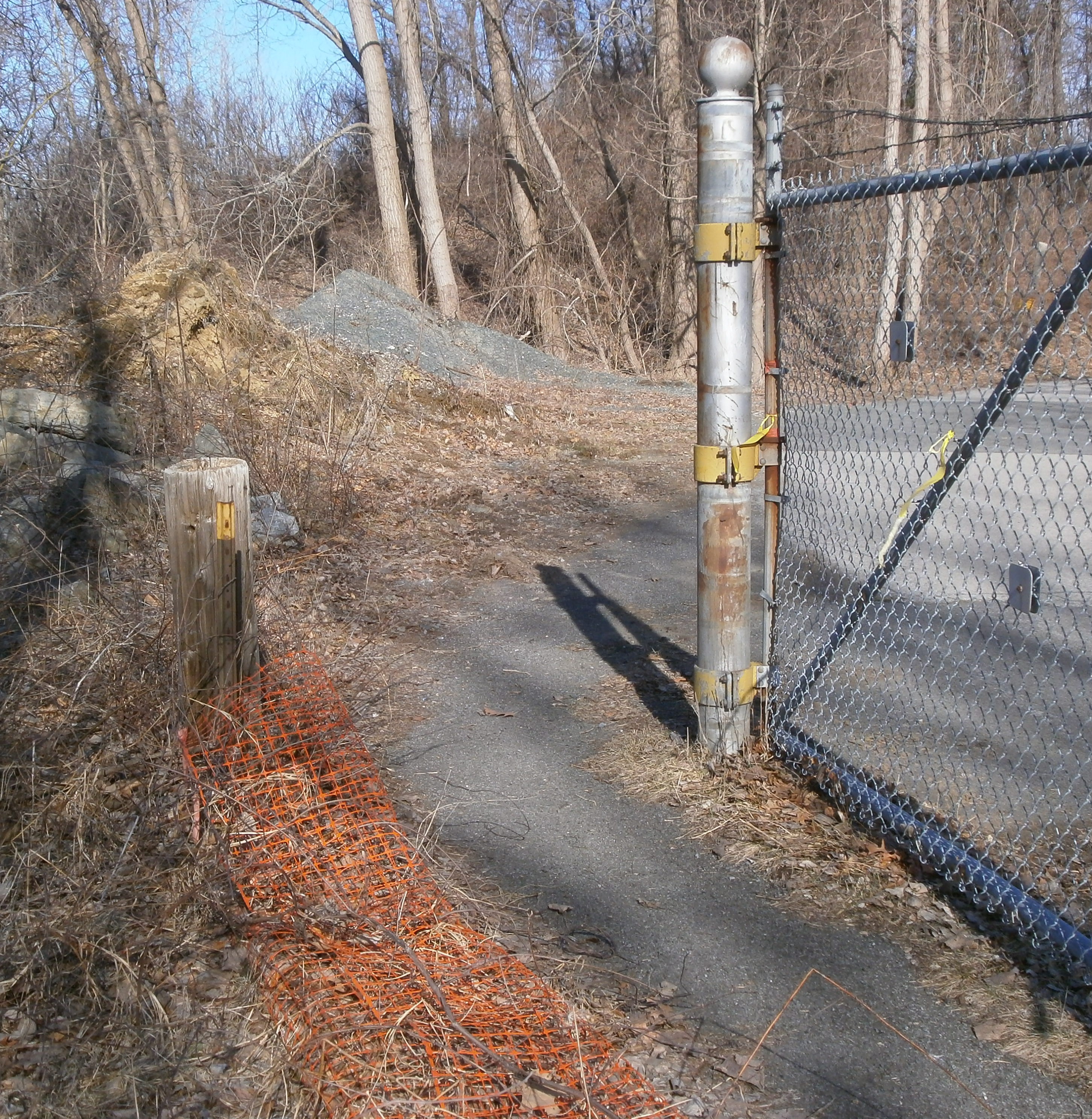
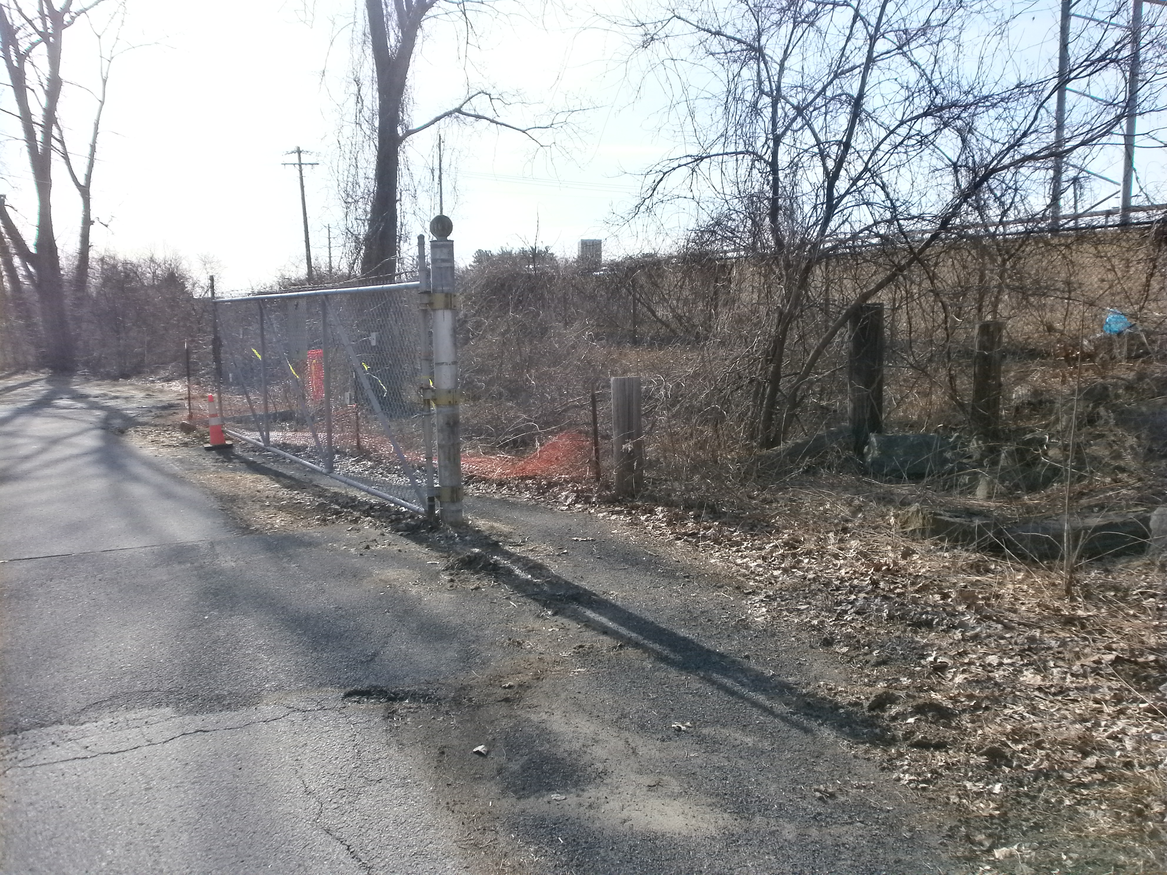
  • WATER AND WATER SUPPLY: We suggest a modifying the paved entry road lying between the park and Washington Ave. Extension and which joins to the lake path at the maintenance building. Pedestrian and bicycle access can be made without defeating the motor vehicle lift gate barrier. You should perhaps change the gate sign from “posted” to “no unauthorized motor vehicles beyond this point.” A little cleanup of the path to the south of the gatepost would also help.

cc:

  • Kathy M. Sheehan, Mayor City of Albany
  • Michael V. Franchini, Executive Director Capital District Transportation Committee
  • Daniel W. DiLillo, Deputy Commissioner – DGS

Photos: Entrance to trail at Rapp Rd., Gate on access road from Fuller Rd., paved access path around gate (two views)

OLYMPUS DIGITAL CAMERAOLYMPUS DIGITAL CAMERA


OLYMPUS DIGITAL CAMERA


OLYMPUS DIGITAL CAMERA

Leave a comment

Filed under Activisim, City Review, Fuller Rd., Trail Network

Blessing or Curse? – the Washington Ave. Flyover

The Washington Ave. Flyover and Related work is complete.  Two cyclists gave their opposing thoughts on the results.  What are yours?

+++++

From a Daily Washington Ave. Extension Commuter – I am VERY deeply concerned.  I suspect it is going to force me to change my route entirely to avoid it.  I go west on Washington.  If I take the flyover, I have cars and garbage trucks coming onto Washington westbound at 55 mph on my right on the on-ramp from Fuller while I am stuck between them and the other traffic doing 55 mph on my left.  This is almost certain death.  If I get off Washington before the flyover and go down the ramp, around the circle, and back up the ramp, I have to assert my right-of-way over the commuters coming south on Fuller Rd. and into the circle while I’m there.  This also strikes me as a death-defying experience.  I cannot say for sure because I have not tried it yet, but I expect this whole thing is going to be a HUGE disaster for my commute.  I think the design is terrible for cyclists and sets us back instead of moving us forward.  It makes one more place no normal cyclist will ever dare go.

+++++
From an Experienced Road Cyclist – I took a ride . . .  through the university and along Washington Ave. Extension.  I do like the new configuration at Fuller Road.  It was easy to do the traffic circle and then the flyover.  The condition of the road surface at that intersection is much improved, needless to say.  And I do like traffic circles.  I think they are fun and despite what others think, I say safer.  Traffic certainly does need to slow down in order to negotiate and this seems to give equal advantage to the cyclist.  [The result] could be cumulative as numbers of cyclists increase.

Leave a comment

Filed under Comings and Goings, Fuller Rd., Local Bike Rides