
The long awaited safe bikeway and multiuse path through Watervliet is coming to fruition. It originates at the park/trail head/parking lot terminus of the off-road portion of the Mohawk-Hudson Bike-Hike Trail and continues for about one and one-half miles to 23rd St. The “Watervliet Bike Path” will become shared lanes at 23rd St. for access to the Hudson Shores Park.
Map of the Project Area
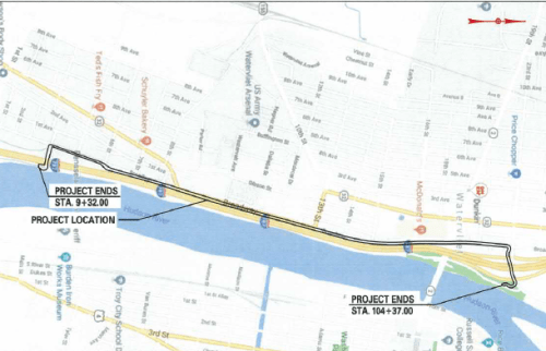
Those continuing to Green Isl. and the Erie CanalwayTrail/Empire State Trailwill continue on shared lanes on Broadway until 25th St. and then follow Albany St. to the Green Isl. Bridge to Troy or Hudson Ave. north – the current route of the Mohawk-Hudson Bike-Hike Trail.
Concept of Broadway Cycle Track
Broadway at 4th St. Exiting From the Park/Trail Head/Parking at Current Terminus of the Mohawk-Hudson Bike-Hike Trail

We were unsuccessful in getting from the City of Watervliet definitive information on the route and road treatments of the Empire State Trail/Watervliet Bike Path from Watervliet through to Green Isl. We are particularly interested in the treatment around the Rt. 2 Watervliet-Troy Bridge and the aforementioned Albany Ave./Hudson Ave./Green Isl. Bridge intersection. The New York State Department of Transportation 2018 “On-Road Routes Concept Plan” for the Empire State Trail sheds no light on this issue.
Progress Just North Of 4th St. – Note Passano Paints

James Roy Mills 1835 – Now Used By Passano Paints

Construction Ahead! (Heading South On Broadway)

Cycle Track Route between Motor Vehicle Lane And I-787 Fence (2 Views)


Cycle Track Base I-787 Fence (North and South Views)


View South with Arsenal Fence to the Right

Heretofore, Broadway from the Mohawk-Hudson Bike-Hike Trail at 4th St. was one of the main barriers for less road-hardened riders going on to Troy, Cohoes, the Black Bridge, Champlain Canal Trail, Waterford, and the many sites along the way. The new bikeway is very impressive and will make the ride a wonderful experience. I-787 will be noisy but the bikeway will be safe and relaxing traffic wise.
Empire State Trail staff graciously provided background resources and some of the information herein.
++++++


Bike lanes on either the rt 2 or green island bridge would be ideal to connect it to troy. The rt 2 bridge in particular has drivers speeding over it all the time (disappointing they did nothing for bikes when they “renovated” it some years past).
Jake,
You are correct on both counts, and we have only the NYSDOT to thank for these egregious errors in planning and design overlaid with complete disregard for all bridge users. When Chris Churchill of the Times Union took DOT to task for not doing a “Complete Streets” design on the Rt. 2 Bridge, the response was “the design work was done BEFORE New York State passed a Complete Streets law.” Clearly, DOT installed 4-lane Bridge to connect a 2-lane street in Watervliet to a 2-lane street in Troy – brilliant!
The Green Isl. Bridge is a similar story – connecting 2 lanes to 2 lanes with 4 lanes. When the bridge was being redone and before it was completed, I tried to find out from people who should have known who was doing the design. When under construction, the bridge worked fine with one lane each way. But, again, NYSDOT chose the most dangerous design for all bridge users.
9/30/13 from DOT: “Governor Andrew Cuomo today announced the reopening of all four lanes of the Congress Street Bridge carrying Route 2 over Interstate 787 and the Hudson River between Watervliet, Albany County and Troy, Rensselaer County. The rehabilitation project was funded through the Governors NY Works program.”
LW
8-6-20