Category Archives: Bike Lanes

Van Rensselaer Blvd. and Tips from the Times Union

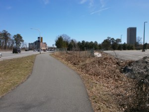
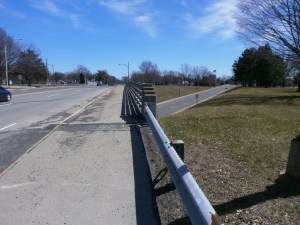
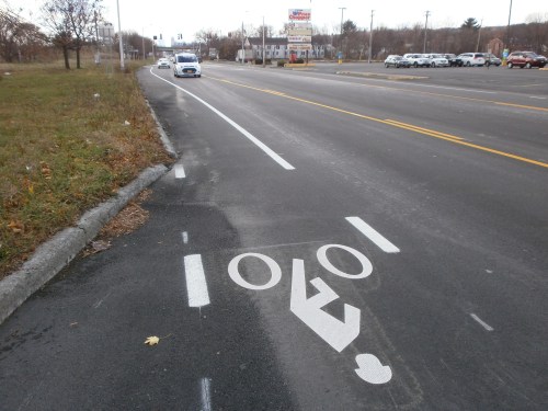
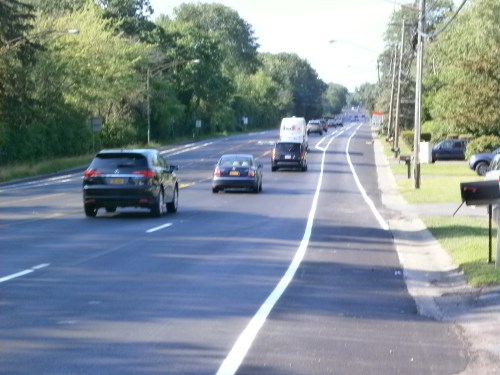
The summer “road diet” project for Van Rensselaer Blvd. is complete. The $1 million project re-striped the former four-lane corridor between Northern Blvd. and Menand Rd. (Rt. 378) into one motor vehicle lane in each direction with a center turn lane. The shoulders are widened to include six-foot bicycle lanes on each side and seven-foot shoulders. The speed limit is now 45 mph (down from 55 mph posted).

Affected area, 1.5 miles – https://www.google.com/maps/dir/42.6772786,-73.7436492/42.6983906,-73.7388047/@42.6866889,-73.7459224,15.37z/data=!4m2!4m1!3e1

For background and in-process photos, see – https://albanybicyclecoalition.com/2017/07/08/89398/ .

As noted there, those who use the BikeAlbanyMap to get around the City of Albany and Parks & Trails New York Erie Canalway Trail map to travel along the Mohawk-Hudson Bike-Hike Trail will note that one can ride the Mohawk-Hudson Bike-Hike Trail from Rotterdam Junction (with a few on-street portions in Schenectady, Cohoes, and Watervaliet), leave the MHBHT at the (hidden and bumpy) Schuyler Flats Trail near Passano Paints and the I-787 underpass at Broadway and 4th Sts. to Schuyler flats, go a short “traffic calmed” half mile south on Broadway, crawl up the hill through Albany Rural Cemetery, join the above described new bicycle lanes on Van Rensselaer/Rt. 377, enjoy the “calmed” Northern Blvd. to McCrossin and Thornton Sts. at the old Livingston Middle School, and then wind through a quiet residential neighborhood to the bicycle lanes on Clinton Ave. It’s almost a network!

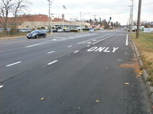
Delaware Ave. Traffic Calming – In other news on 10/16/17, the Times Union recommended adoption of Bethlehem’s “Delaware Avenue diet.” See http://www.timesunion.com/opinion/article/Editorials-Long-story-short-12278566.php . This proposal – to go from four lanes to three makes room for bicycle lanes as well as improving safety FOR ALL along the busy road with a minimal impact on automobile traffic. This project is modeled after the Madison Avenue Traffic Calming project now moving rapidly to completion.

++++++

Editorial Note – While one cannot be anything but pleased at this Van Rensselaer Blvd. project, it does exploit bicycle facilities as a way to calm motor vehicle traffic – not a bad thing, but, in this case, the end at Menand/Osborne Rd. (Rt. 378) leaves something to be desired. For people on bicycles who NEED bicycle lanes, Menand/Osborne Rd. would not be a travel choice they would make. As noted, one can use the Albany Rural Cemetery Rd. to get to Broadway and the Mohawk-Hudson Bike-Hike Trail. Further, the redesign of Van Rensselaer Blvd. still leaves it looking like a high-speed road much as I-787 looks entering/leaving Cohoes, much of Central Ave., and Washington Ave. (where the posted speed limits have been reduced on a road that looks and feels like a higher speed is appropriate).

1 Comment

Filed under Bike Lanes, City Review

Bicycle Lanes (and Traffic Calming) on Van Rensselaer Blvd./Rt. 377

Van Rensselaer/Rt. 377 Bicycle Lanes – There soon will be two lanes for motor vehicles, left turn bays, and bicycle lanes on Van Rensselaer. These are a great tie-in with Northern Blvd.’s bicycle lanes.

The first photo shows the start of the new lanes (as yet uncompleted) at Northern Blvd.

OLYMPUS DIGITAL CAMERABut there’s more…

NYSDOT is completing this recent project in consultation with the City of Albany on project scope. It builds on the 2015 bicycle lanes/traffic calming installation on Northern Blvd. The city will expand the bicycle lane project on Northern Blvd from the I-90 bridge north toward Albany-Shaker Road later this summer. Notably the lane treatment at the southern end of Northern Blvd. is one of the best designs you will find in the region. Note the bottom photo with a nice buffer.

Those who use the BikeAlbanyMap and Parks & Trails New York Erie Canalway Trail map will note that one can ride the Mohawk-Hudson Bike-Hike Trail from Rotterdam Junction (with a few on-street portions in Schenectady, Cohoes, and Watervaliet), leave the MHBHT at the (hidden and bumpy) Schuyler Flats Trail near Passano Paints and the I-787 underpass at Broadway and 4th Sts. to Schuyler flats, go a short half mile south on Broadway, crawl up the hill through Albany Rural Cemetery, join the above described new bicycle lanes on Van Rensselaer/Rt. 377, enjoy the “calmed” Northern Blvd. to McCrossin and Thornton Sts. at the old Livingston Middle School, and then wind through a quiet residential neighborhood to the bicycle lanes on Clinton Ave.

It’s almost a network!

OLYMPUS DIGITAL CAMERA

4 Comments

Filed under Bicycle Boulevards, Bike Lanes, City Review

Washington Ave. – Watcha’ Gonna Do?

OLYMPUS DIGITAL CAMERA


OLYMPUS DIGITAL CAMERA

The recent reduction in speed limits on Washington Ave. from Brevator to Fuller Rd. (from 40 to 30 mph) and from Fuller to Rt. 155/Karner Rd. (from 55 to 45) invites immediate reconsideration of the street for use by people on bicycles and for increased safety for all road users. Opening almost 4 miles on Washington Ave. for all users would provide a major commuter and recreational route and would connect the City of Albany to Schenectady and the suburbs with benefits to all. Specifically for people on bicycles, a traffic-calmed Washington Ave. would connect to the Six Mile Waterworks Park trail (and thence to Lincoln Ave./Rapp Rd. and then to Central Ave.) allowing riders to bypass the dangerous Wolf Rd. – Central Ave. area.

To support this approach, we need only note that, although the official speed is now lower, the configuration of the road and the clear message it sends to people in cars is – 40, 45, 50, 55, 60 mph – it’s all good. The entire Albany Police Department could not “police” speeders on Washington Ave. The simple solution is to abandon this configuration of wide lanes with negligible build up or greenery near the roadway, wide shoulders, and 4 lanes. We can send a “complete streets message” by taking advantage of these wide shoulders and extra wide motor vehicle travel lanes to provide 11-foot travel lanes and bicycle lanes on each side from Manning Blvd. to 155/Karner Rd..

A positive feature of Washington Ave. is that it lies under only one jurisdiction – the City of Albany – and is not a New York State numbered route. This means that it is unnecessary to navigate many levels of government to make these changes.

Another aspect of Washington Ave. is the “trail to nowhere” that starts on the sidewalk at the Fuller Rd. underpass/traffic circle on the south side of Washington Ave. (2.4 miles from Manning Blvd.). This multi-use path runs to an abrupt end at the Collin’s Circle entrance to the University at Albany. On its way there, the multi-use path crosses one campus access road (W. University Dr.) with no bicycle accommodations but with pedestrian crossing signals. (With Albany’s “right turn on red after pause ’rule’,” all these University at Albany entries are high-risk crossings.)

There is unencumbered real estate for continuation of this path from Collins Circle to the New York State Harriman Campus western border near the traffic lights controlling access to the office complex at 1365-1367-1375 Washington Ave. (3.8 miles from the start of the multiuse path at Fuller Rd.). Possibly, all that is needed is straightforward signaled crossover for pedestrians and for people on bicycles (to switch between the multi-use path and the bicycle lanes).

Here is a look at Washington Ave. (photos dated 4-9-17):

  1. (photo above) Super Mirage at Fuller at Wash Ave
  2. (photo above)Fuller at Wash Ave – Looking east
  3. Aspen & Quad Wash Ave-UA – Looking east
  4. Collins Cir Entrance Wash Ave-UA – Looking east
  5. Looking toward new Path Wash Ave-UA – Looking east
  6. E Bridge over Ring Rd Wash Ave-UA
  7. Exit to Patroon Creek and Ring Rd Wash Ave-UA
  8. Bridge Over Rt 85 at Jermain St Wash Ave-UA – Looking east
  9. Exit to Rt 85 from Wash Ave-UA
OLYMPUS DIGITAL CAMERA

3. Aspen & Quad – Looking East


OLYMPUS DIGITAL CAMERA

5. New Path Route East?

OLYMPUS DIGITAL CAMERA

6. East Bridge Over NYS Campus Ring Rd.


OLYMPUS DIGITAL CAMERA

7. Exit to Patroon Creek and NYS Campus Ring Road


OLYMPUS DIGITAL CAMERA

8. Bridge Over Rt 85 at Jermain St.


OLYMPUS DIGITAL CAMERA

9. Exit to Rt 85 from Washington Ave.


4 Comments

Filed under ABChallenge-2017, Bike Lanes

A Simple Solution to an Elegant Problem?

A frequent discussion item is the perceived risk for people on bicycles who are forced to ride though hellish intersections. These include, but certainly are not limited to: Central Ave./Wolf Rd., Western Ave./I-87/Fuller Rd., the Fuller Rd. “flyover” on Washington Ave., and Central Ave./Everett Rd.

In 2014 in a similar situation, the Village of Menands with New York State Department of Transportation oversight, installed a short stretch of bicycle lanes on Rt. 32/Broadway at the Rt. 378/I-787 entrance/exit ramps. (This was an earlier component of an overall re-do Rt. 32/Broadway in the village. Notably, much of this was reduction in motor vehicle travel lanes from four to two – as in the stretch in front of River View Center [Montgomery-Wards] leading north over the railway tracks into the village.)

OLYMPUS DIGITAL CAMERA

The first photo (above) looks north just past the soon-to-closed Price Chopper. The iron fence in the left of the photo is Albany Rural’s with CorrCraft and Albany Steel following and the Schuyler Motel on the right with its sign between the second and third utility poles. The second photo (below) looks south with the Price Chopper “plaza” to the right and the Rt. 378 overpass in the distance.

OLYMPUS DIGITAL CAMERA

At the time this was done, NYSDOT stated: “The reduction in the number of travel lanes from four to two with a two-way left-turn median in the center … reduces the frequency of rear-end accidents. We understand . . . that there are not left-turning opportunities at all locations where the median is provided, however it is important that the thru travel lanes have a consistent alignment. There may be a minor reduction in the efficiency of the operation of Route 32 but the safety benefits are significant.”

So … is it possible that low-budget projects (as the above) could provide visible bicycle facilities to guide both people in cars and on bicycles through troublesome intersections? This could be done without a complete (and expensive) re-do of the entire street with full-scale bicycle lanes. If you’ve ridden the section in Menands described above or Madison Ave./Main Ave. intersection, you might have an idea on how this might work successfully elsewhere.

Leave a comment

Filed under Bike Lanes

SEBL Funded! Construction of the City of Albany South End Bikeway

Alert Cyclist Mark informs us as follows:

The State’s Regional Economic Development Council Awards for 2016 includes (page 81, middle of the page, project #627184) $325,000 toward design and construction of the South End Bikeway Link. It is described as a “two-way, Separated Bike Lane, also known as a cycle track, extending along the east (ED: river/port/RR) side of South Pearl Street where sidewalks exist.” The Times Union story is here.

The full project (with editorial corrections) is as follows: The City of Albany will design and construct the South End Multi-Use Trail, located in the South Waterfront District, that will link the Albany County Helderberg Hudson Rail Trail to the Mohawk-Hudson Hike-Bike Trail/Erie Canalway Trail, filling a gap in a more than 360-mile multi-use trail network. The proposed treatment is a two-way, Separated Bike Lane, also known as a cycle track, extending along the east side of South Pearl Street where sidewalks exist.

The funding of the South End Bikeway Link is perfectly timed with the pending completion of the Corning Riverfront Park Protected Bicycle Lanes and the other amenities as well as with completion of ABC’s BikeAlbanyMap. The three projects now provide people on bicycles with many options for safely and efficiently transporting themselves around the city and region.

tumblr_og9qebuctg1uzhyk9o1_540

OLYMPUS DIGITAL CAMERA

Building the ACHHRT


1 Comment

Filed under Albany County Rail Trail, Bike Lanes, Corning Riverfront Park, Erie Canal Trail