
[UPDATED 7-1-20]
There are 0.2 miles of new bicycle lanes on Northern Blvd.-Manning Blvd. running from Pennsylvania Ave./McCrossin St. to Lark Dr. This expands the Northern Blvd. /Memorial Hospital area bicycle lane network to a total of 1.4 miles. The network connects to the Village of Menands/Department of Transportation 1.5 miles of bicycle lanes on Van Rensselaer Blvd. (See more background and photos here: Bicycle Lanes in the City of Albany.)
This brings the City of Albany total installed bicycle lanes to 4.9 miles. The final 2009 Albany Bicycle Master Plan designated 18 “major bikeways” within the City of Albany. While the plan did not specify bicycle road treatments, it suggested many – Including bicycle lanes but with long stretches of shared lanes. In several instances, the plan called for narrowing motor vehicle travel lanes to provide space for bicycle lanes. The approximate total miles of these 18 bikeways is 40.64 (using Google Maps distance function). While not a 1:1 comparison, this 4.9 miles of bicycle lanes is 12 percent of this total.
With anticipated completion of the South End Bikeway Connector (about 1.5 miles of cycle track/bicycle lane plus a side path), the total will be 6.3 miles or 16 percent of the 2009 total.
New bicycle lanes – looking southeast from Northern Blvd. toward Manning Blvd. The bridge crosses the I-90/I-787 entrance/exit ramps.
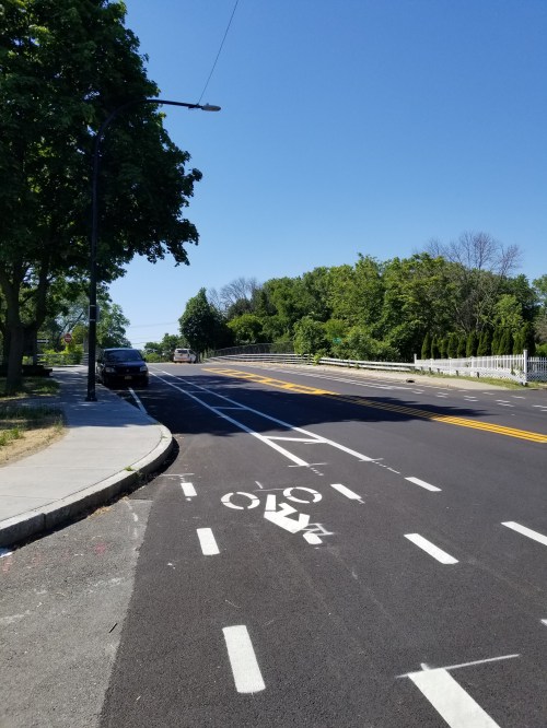
A view in the same direction with Northern Blvd. petrovehicle traffic entering from the left and Pennsylvania Ave. on the right (taken from McCrossin Ave.).

Looking back up Manning Blvd. toward Northern Blvd. from Lark Drive. The Albany Fire Department Arbor Hill Station is to the right. Note buffered bicycle lane.
There’s still a challenging “shared lane” area on the Rt. 9 overpass – high speeds, no rideable shoulders, entrance/exit ramps to/from Northern Blvd. to Rt. 9. The proper use of a Shared Lane is to connect “real” bicycle facilities. According to National Association of City Transportation Officials (https://nacto.org/publication/urban-bikeway-design-guide/bikeway-signing-marking/shared-lane-markings/ ) Shared Lane Markings (SLMs), or “sharrows,” are road markings used to indicate a shared lane environment for bicycles and automobiles. The shared lane marking is a pavement marking with a variety of uses to support a complete bikeway network; it is not a facility type and should not be considered a substitute for bike lanes, cycle tracks, or other separation treatments where these types of facilities are otherwise warranted or space permits.
In the instant case, the SL do connect two of bike lane segments. It’s still a squeeze unless the rider ‘takes the lane.”


