
~ DRAFT ~
See also – “Patroon Greenway Project – Yardboro Ave. to Everett Rd.”
Overview – The Patroon Greenway Project describes a transportation/recreation multiuse path connecting the Six-Mile Trail on Fuller Rd. with the Albany Riverfront Park. The trail generally follows Patroon Creek, Tivoli Hollow, Route I-90, and the AMTRAK/CONRAIL railway tracks.
The Patroon Greenway connects several other tails as outlined in the Capital District Transportation Committee’s “Capital District Trails Plan – 2019”
There are three Patroon Greenway Project studies conducted in 2004 and are as follows:
- Existing Conditions – May 2004
- Regional Impact Analysis – Undated
- Cost and Funding Options – October 2004 (https://www.cdtcmpo.org/images/linkage_program/AlbCoFinal/pg-Cost-and-Funding-Options.pdf )
The Exploratory Ride – On Sunday November 3, 2019, Rob Carle led a team of Mark Maniak, John Gillivan, Ed Brennan, and Shelly Nevard on a trial run of the Patroon Greenway Trail.
![Fuller-To-Central-Section[1]](https://albanybicyclecoalition.com/wp-content/uploads/2019/12/fuller-to-central-section1.jpg?w=458&h=344) We started across at Six Mile Waterworks Park. We crossed used the crosswalk north of the circle to get access to the Ultrapet parking lot and the beginning of the trail. At the time of the Patroon Creek Studies (2004 – note at end of this report), there was a traffic light at this location. This is now less navigable for bikes and pedestrians.
We started across at Six Mile Waterworks Park. We crossed used the crosswalk north of the circle to get access to the Ultrapet parking lot and the beginning of the trail. At the time of the Patroon Creek Studies (2004 – note at end of this report), there was a traffic light at this location. This is now less navigable for bikes and pedestrians.
The Study route also did not employ the parking lot to get to the trail. Rather it would hug the I-90 ramp on DOT property until meeting the trail east of the Ultrapet parking lot. The picture below showing an electrical substation and water tower base was by the start of where we began the trail.
While it was OK for the first couple of hundred yards, this first section of trail was in turn muddy, sandy and covered with a heavy layer of leaves. It is notable that Mark somehow managed it with thin tires. I imagine most of the thin tire crowd would have turned back. As we approached Yardboro Ave. we came upon an improved section with recently laid compacted gravel. This was apparently done to provide access from Yardboro Ave. to City or County Water Department facilities near I-90.
We took a left on Kneeland Street proceeded along Yardboro Ave. to Central Ave. Here again we diverged from the proposed route which would have been off road closer to I-90. As this is a small, low traffic neighborhood, I see little benefit to the cost of making this section off road. Neighbors might see things differently. The lack of space between neighborhood streets and the I-90 ramps to Harriman State Offices and Rt 85 probably also dictate this be an on road section.
I note here the Study author indicated the ramp to Harriman offered the potential to link the Greenway with the State Offices and SUNY. He envisioned using this I-90 overpass and Washington Ave underpass to access the state campus loop. I believe this concept was recently resurrected in Washington Ave study. However, I see issues with the merger of this ramp with the eastbound exit ramp from I-90. The grade crossing where the ramps merge is also noted in the Study.
The Study calls for a median refuge on Central Ave at the Yardboro Ave. crossing with flashing safety beacons. Rob recommended another crossing to give bicyclists and pedestrian’s access to Railroad Ave. to provide additional traffic calming for this section of Central Ave.
Once across Central, we had to lift our bikes over a locked gate to continue along the trail. The Study notes this is National Grid property with County Water and Sewer Rights of Way. The Patroon Creek is visible along much of this trail section which has potential for being somewhat scenic. The trail itself was rough and had some massive water filled ruts and potholes. We followed the trail under Everett Road. Though in need of rehabilitation, the trail from Fuller to Everett was generally flat and wide. Beyond Everett Road the trail gets hemmed in between I-90 and the tracks. As we edged closer to the railroad tracks we also had to deal with the track ballast stones and had to walk our bikes more often. Eventually, we reached the underpass where I-90 crosses the tracks. As shown below this is a very tight pinch point and I’m certain authorities would not permit a bike path along this section without substantial improvements.
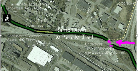
![I-90-Underpass-C[1]](https://albanybicyclecoalition.com/wp-content/uploads/2019/12/i-90-underpass-c1.jpg?w=463&h=347) The Study imagines that the trail will follow north side of I-90 and along a cantilever bridge to cross the railroad tracks. It would then cut back under I-90 using Anderson Rd. The Study trail would then use redeveloped abandoned rail trestles to cross back over the tracks to a point near the Freihofer (now Bimbo) Bakery site. Note the pointer to Anderson Rd at the top of the picture below. Everett is at the bottom.
The Study imagines that the trail will follow north side of I-90 and along a cantilever bridge to cross the railroad tracks. It would then cut back under I-90 using Anderson Rd. The Study trail would then use redeveloped abandoned rail trestles to cross back over the tracks to a point near the Freihofer (now Bimbo) Bakery site. Note the pointer to Anderson Rd at the top of the picture below. Everett is at the bottom.
Anderson Rd.
^ Everett
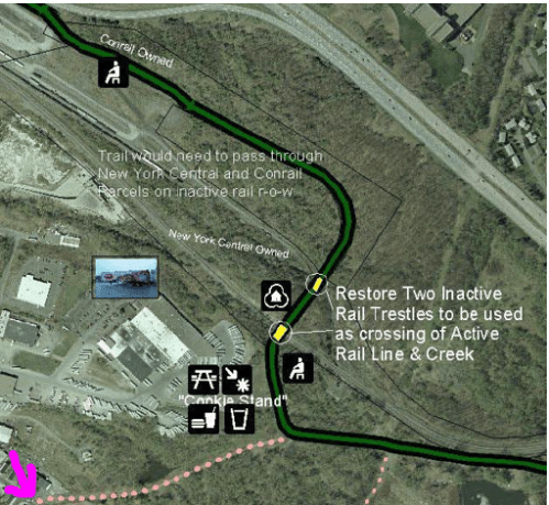
The Study section showing the Trail crossing the abandoned trestles leading back to a point near Tivoli Park is shown below. I also drew a pink arrow pointing to an existing Livingston Ave. entrance to the Tivoli Park Trails. The costs of constructing the cantilever bridge, restoring and modifying the trestle bridges would be significant and would require significant negotiations with the Railroads. The Study plan would solve the difficult issues of crossing I-90, the tracks and Everett Road.
As there was no such cantilever bridge at present, we pushed our bikes under I-90 and carried our bikes over to the north side of the tracks. We noted the trestle crossing the tracks. As the trail on the north side of the tracks soon vanished, we carried our bikes back over to the south side near Tivoli Park. After a bit of bumbling about we found we could carry our bikes down an embankment and onto a very nice new trail through Tivoli Park. This new trail section is apparently part of a water drainage project. There were hundreds of new plantings in place and being prepared for landscaping. This is going to be a gem of a trail section when completed. We followed it out of Tivoli Park and out to Northern Boulevard. As it was getting late we left the rest of the ride to Corning Trail for another day and headed back via city streets.
New Tivoli Park Trail
![Tivoli-Trail[1]](https://albanybicyclecoalition.com/wp-content/uploads/2019/12/tivoli-trail1.jpg?w=341&h=256) It should be noted that the Study anticipated the rest of the bike route from Tivoli Park to the Corning Trail would be by City Streets. The author thought the options of a) following the deep railroad ravine or b) cantilevering along I-90 would be too costly and would not provide significant advantages for neighborhood users. Here I believe the Study’s proposed route could be adjusted to use some of Albany’s few improved bicycle friendly roads and other improvements following Northern Blvd to Manning to Ten Broeck to Clinton to the “To Be Repurposed” 787 Ramp to the Hudson/Corning Trail.
It should be noted that the Study anticipated the rest of the bike route from Tivoli Park to the Corning Trail would be by City Streets. The author thought the options of a) following the deep railroad ravine or b) cantilevering along I-90 would be too costly and would not provide significant advantages for neighborhood users. Here I believe the Study’s proposed route could be adjusted to use some of Albany’s few improved bicycle friendly roads and other improvements following Northern Blvd to Manning to Ten Broeck to Clinton to the “To Be Repurposed” 787 Ramp to the Hudson/Corning Trail.
I think the biggest problems with developing the trail at present are 1) fixing the crossing of Fuller Road, which was a tragic victim of Traffic Circle Madness and 2) figuring out a cost effective method of connecting from Everett Road to Tivoli Park.
One of the study conclusions was that it would be important to find some early “wins”. I think the early wins would need to be very cost effective. If parts of the trail were opened, even with on road sections, this could generate public demand for fixing the more expensive sections. A very easy win, and one that might resound with the powers that be, would be to first link the new Tivoli Trail with the Corning Trail via the politically popular Repurposed 787 Ramp.
Another win could be connecting Central at Yardboro with Fuller. However, I think the traffic circle at Fuller is so dangerous the cost of fixing that circle would need to be worked in. The same is probably true of Central Ave. Even if the trail did not immediately continue on the other side, pedestrians and cyclists would need somewhere safe to cross if they wanted to continue north or west.
In the shorter term there are other ways of connecting the trail from Everett to Tivoli Park without cantilever bridges and rehabilitated rail trestles. The Study noted the
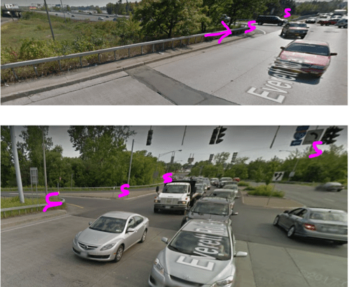
![Dutch Stairs[1]](https://albanybicyclecoalition.com/wp-content/uploads/2019/12/dutch-stairs1.png?w=337&h=264)
possibility of building a Dutch Stair from the Trail to the East side of Everett Road which is 20 feet overhead. The Dutch Stair concept was used on the pedestrian bridge across I-787 to Jennings Landing. By accessing the East side of Everett, cyclists and pedestrians could follow a sidewalk/street route to Tivoli by following Watervliet Ave. Extension, continuing onto Commerce Ave., turning right on Terminal Street and left on Livingstone Ave.. As pointed out in pink above there is currently access to the Tivoli Park trails on Livingston Ave. Below are a diagram of the Dutch Stair concept, a pointer to where the stair might emerge on Everett and “S” indicators where signaling might be used on Everett to allow safe passage.
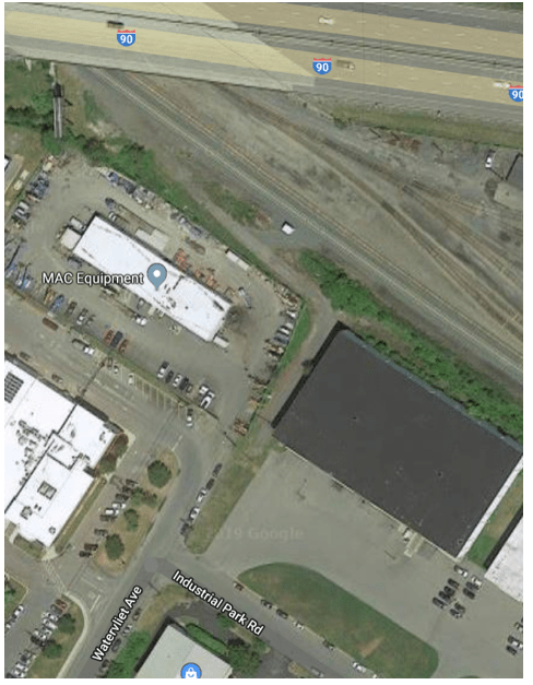
Alternatively, it may be possible to continue under I-90 as our group did. There would certainly need to be some fencing to separate cyclists from the railway. Once on the south side of I-90, it should be possible to access Watervliet Ave. and then take a left onto Commerce Ave. and continue onto Corning Trail as described above. This would doubtless require negotiation with and acquiescence of the Railroad and businesses at the end of Watervliet Ave. Some of the other conclusions of the Study were that the Greenway would need a “champion”, a study group and a “friends of the trail”. I think that ABC could play a role in each of these tasks.
+++++++++


Pingback: Downtown Albany and Patroon Creek | Albany Bicycle Coalition