Category Archives: South End Bikeway Connector

South End Bikeway Connector Rumbles Along – Cont’d (11/22/19)

Here are today’s (11/22/19) views of progress on the South End Bikeway Connector. From them, it is clear that the South End Bikeway Connector will be open from Church St. at the RR tracks to the Helderberg Hudson Rail Trail trailhead at Old S. Pearl St. by the end of the construction season. According to the City of Albany, the remainder will be completed in 2020. In the meanwhile, riders will be able to access downtown Albany along Green St. or veer off Green St. to the right onto 4th Ave. to access Broadway. An alternative is to turn right (east) at the RR tracks to take Broadway directly to the Mohawk-Hudson Bike-Hike Trail at the Slater/Dutch Apple mooring and then onto Buffalo on the Erie Canalway Trail.

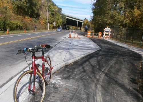
The first shows the general layout of the connection from the trailhead to the South End Bikeway Connector (looking north from the parking lot).

OLYMPUS DIGITAL CAMERA

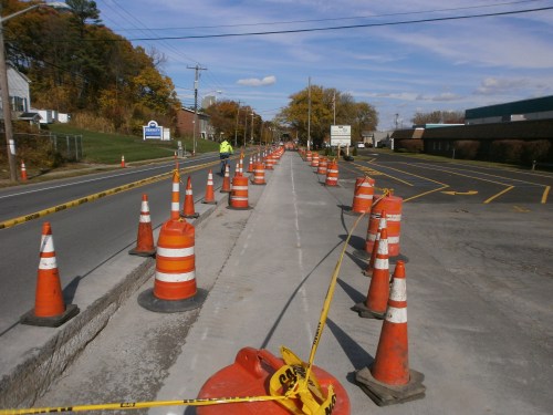
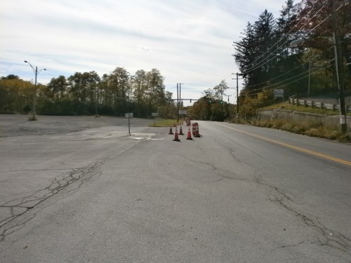
Next, a couple views of the actual 2-way protected bicycle lanes on S. Pearl St. (formerly Orchard St., Washington St., Common Ln., Cow Ln., and Cow St.). The construction pylons are not the final “protection” – they are to keep petrovehicles and those humongous trucks out of the cycle track until conclusion of construction.

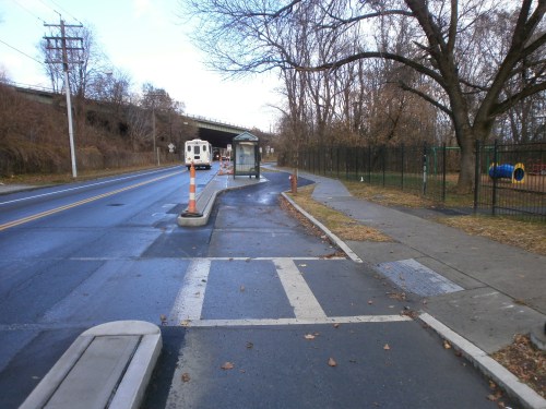
Here is a nice view of Capital District Transportation Authority’s brand new bus shelter on its new concrete pad with the protected bicycle lane passing behind the shelter and onto the I-787 “Frontage Rd.”

OLYMPUS DIGITAL CAMERA

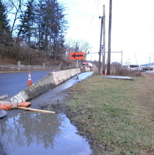
These views looking south from Church St. (named for the nearby St. John’s and “Dutch” churches) show the cycle track with a landscaped barrier. This is the likely end of South End Bikeway Connector construction for 2019.

~ The South End Connector Bikeway Route Description ~

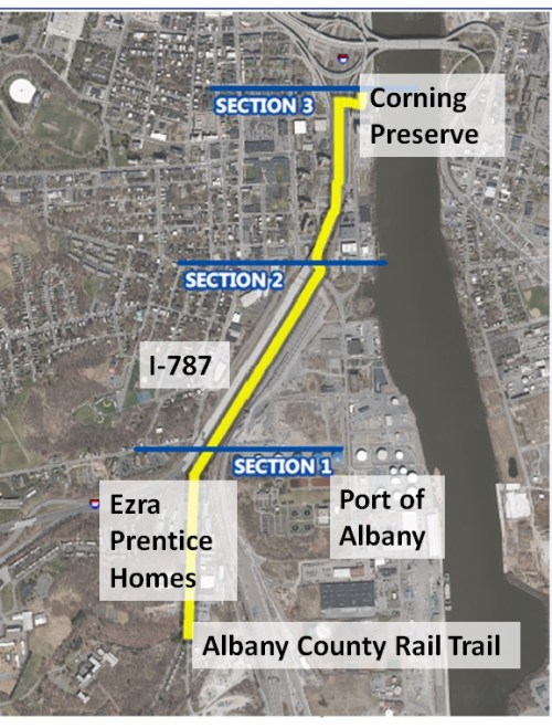
A South End Bikeway Connector route description follows below. When completed, the SEBC will be the first Protected Bicycle Lanes in the City of Albany and the first bicycle lanes that actually connect up to other facilities – the Helderberg Hudson Rail Trail and the Mohawk-Hudson Bike-Hike Trail/Erie Canalway Trail/Empire State Trail. According to the City of Albany, construction on the SEBC will continue until the end of the 2019 construction season. With this additional 1.5 miles of bicycle lanes, Albany will have a total of 6 miles of bicycle lanes just in time for the 10th anniversary of the Albany Bicycle/Pedestrian Master Plan.

The bikeway begins at S. Pearl St./Old S. Pearl St. in the Helderberg Hudson Rail Trail trailhead and parking lot. Between Old S. Pearl St. and Mt. Hope Dr. and the Frontage Road (the I-787 northbound entry road), there will be a separated, on-street, two-way cycle track. (This two-way feature alleviates the need for people on bicycles to cross S. Pearl St.) The cycle track will continue onto the east/river side of the Frontage Rd. to Church St. It will then briefly turn west before continuing on an off-road, 10-foot wide, multi-use trail and linear park underneath I-787 to Broadway and Quay St. To skirt the I-787 support structure, at the Church St./Bassett St. intersection the connector will be on-road until Rensselaer St. Here it again it will shift back off-road until the turn toward the Hudson River, the Slater and Dutch Apple mooring, and the Mohawk-Hudson Bike-Hike Trail/Albany Riverfront Park. To accommodate the connector’s path, Church St. from Rensselaer St. to Bassett St. will become a one-way southbound. Broadway currently consists of four travel lanes – two eastbound and two westbound. One lane on will be removed to construct the multi-use path on the south side of Broadway (where it passes under I-787), resulting in one westbound lane and two eastbound lanes.

++++++

Leave a comment

Filed under Albany County Rail Trail, Albany Riverfront Park, City Review, South End Bikeway Connector

South End Bikeway Connector Rumbles Along – 10/26/19

Construction is fully underway on the long-awaited South End Bikeway Connector. [Photos from 10-26-19. For route description, go to end of this post.]

LOOKING NORTH – New CDTA bus stop at Mt. Hope Dr. People on bicycles will ride behind it and then veer off to toward the river and onto the cycle track on the I-787 northbound entry road.OLYMPUS DIGITAL CAMERALOOKING NORTH – The new cycle track on Frontage Road, the I-787 northbound entry road leading to Church and Vine Sts. (“One lane taken form cars, one lane added for bicycles.”) (“Tank Bombs” very much in evidence.)OLYMPUS DIGITAL CAMERALOOKING SOUTH TOWARD THE RAIL TRAIL – Cycle track replacing the eastside parking along S. Pearl St.OLYMPUS DIGITAL CAMERA

sebc-two-way-cycle-track-9-13-19

LOOKING NORTH – Cycle track under construction on east/river side of S. Pearl St. Note brave cyclist riding in the motor vehicle lane. There is no choice while the road is under construction. For orientation, note the blue and white Bennet sign to the west. Note pavement cut marks and compare final width shown in Photo #3 and 4.OLYMPUS DIGITAL CAMERALOOKING SOUTH – Helderberg Hudson Rail Trail trailhead and parking lot is to the left just past the pylons.OLYMPUS DIGITAL CAMERA

~ The South End Connector Bikeway Route Description ~

The bikeway begins at S. Pearl St./Old S. Pearl St. in the Helderberg Hudson Rail Trail trailhead and parking lot. Between Old S. Pearl St. and Mt. Hope Dr. and the Frontage Road (the I-787 northbound entry road), there will be a separated, on-street, two-way cycle track. (This two-way feature alleviates the need for people on bicycles to cross S. Pearl St.) The cycle track will continue onto the east/river side of the Frontage Rd. to Church St./Vine St. It will then briefly turn west before continuing on an off-road, 10-foot wide, multi-use trail and linear park underneath I-787 to Broadway and Quay St. To skirt the I-787 support structure, at the Church St./Bassett St. intersection the connector will be on-road until Rensselaer St. Here it again it will shift back off-road until the turn toward the Hudson River, the Slater and Dutch Apple mooring, and the Mohawk-Hudson Bike-Hike Trail/Albany Riverfront Park. To accommodate the connector’s path, Church St. from Rensselaer St. to Bassett St. will become a one-way southbound. Broadway currently consists of four travel lanes – two eastbound and two westbound. One lane on will be removed to construct the multi-use path on the south side of Broadway (where it passes under I-787), resulting in one westbound lane and two eastbound lanes.

Leave a comment

Filed under Albany County Rail Trail, Albany Riverfront Park, City Review, South End Bikeway Connector

Construction Begins – South End Bikeway Connector

Today, Monday 9/16/19, marks the official City of Albany date for commencing construction on the South End Bikeway Connector. A survey of the entire route revels serval “road work ahead” signs – generally, a sure indication that work is to begin. (These signs may well be from earlier projects.)

The City of Albany 9/13/19 press release with images follows:

 CITY OF ALBANY – OFFICE OF THE MAYOR

  • 24 EAGLE STREET, ALBANY, NEW YORK 12207, mayor@albanyny.gov, (518) 434-5100
  • Date: September 13, 2019
  • Contact:  Yasmine Robinson, Deputy Director, City of Albany Department of Planning & Development, yrobinson@albanyny.gov , (518) 434-2583

* * NEWS RELEASE * *

City of Albany Announces Commencement of South End Connector Bikeway Construction – Road Construction, Parking Restrictions, & CDTA Bus Stop Closures Also Announced

ALBANY, NY – Beginning on Monday, September 16, 2019 and continuing through Spring 2020, the City’s contractor will construct the South End Connector Bikeway – the highly anticipated connection between the Albany County Helderberg-Hudson Rail Trail and the Mohawk Hudson Bike-Hike Trail (map shown in Image 1).

SEBC - Map 9-13-19

The South End Connector will link these two highly utilized trails with a combination of off-road and on-road pathways for bicyclists and pedestrians. This initiative is consistent with recommendations within the Albany 2030 Plan and the City of Albany Bicycle Master Plan, and further connects the Capital Region to the Empire State Trail.

Travel Lane Adjustments – Construction beginning on Monday, September 16 will include restriping and the creation of a raised-curb median along South Pearl Street from Old South Pearl Street to Mount Hope Drive. Concrete barriers will be temporarily used to note lane shifts until construction of the Capital District Transportation Authority’s Bus Rapid Transit River Line is complete in 2020, however no lane closures are anticipated during construction.

Parking RestrictionsDuring construction, parking will be prohibited on the east side of South Pearl Street between Old South Pearl Street and the Frontage Road.

CDTA Bus Stop Closures – During construction of CDTA’s Mount Hope northbound station, all existing bus stops along Pearl Street and Mount Hope Drive will remain operational except for one stop closure in the northbound direction on Pearl Street at Ezra Prentice Homes (as shown in Image 2).

Print
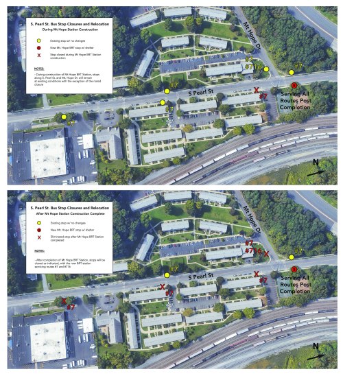
After completion of the Mount Hope northbound station, stops on Pearl Street south of the new station will be closed, with the Mount Hope station serving all northbound routes. Closed stops will be visibly indicated with a CDTA blue bag and public notices.

 About the South End Connector BikewayWhen complete, the South End Connector will create a bikeway from South Pearl Street & Old South Pearl Street to Church Street, along the Frontage Road intersection, and then continue underneath Interstate-787 to Broadway and Quay Street as depicted in Image 1. Between Old South Pearl Street and the Frontage Road, there will be a separated on-street two-way cycle track, the first in the City of Albany, depicted in Image 3.

SEBC - Two Way Cycle Track 9-13-19

Construction of a 10-foot wide multi-use trail will run beneath the Interstate-787 corridor from the intersection of the Frontage Road and Church Street to the Broadway and Quay Street intersection. At the intersection of Church Street and Bassett Street, the Connector will be on-road until Rensselaer Street where it will then shift off-road. The northbound lane of Church Street from Rensselaer Street to Bassett Street will be removed and Church Street will become a one-way roadway in the southbound direction.

Broadway currently consists of four travel lanes; two in the eastbound direction and two in the westbound direction. One lane on Broadway will be removed to construct the multi-use path on the south side of Broadway, resulting in one westbound lane and two eastbound lanes when construction is complete. Construction will include installation of new curbing along the south side of Broadway and modifications of existing striping along Church Street and Broadway.

Funding for this project has been provided in part by the New York State Department of State under Title 11 of the Environmental Protection Fund, as well as The Climate Smart Community Grant Program, Title 15 of the Environmental Protection Fund through the NYS Department of Environmental Conservation.

++++++


Leave a comment

Filed under Bike Lanes, Rail Trail, South End Bikeway Connector