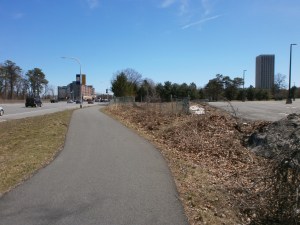
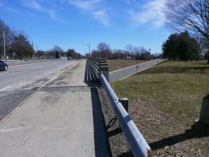
Washington Ave. Flyover – A Call for Change – In fall 2012, the long awaited “Flyover” to route through motor vehicle traffic from Washington Ave. to the Washington Ave. Extension was completed. This and the accompanying series of traffic circles on Fuller Rd. were clearly designed under an “all cars-all the time” philosophy. These means that people on bicycles who want to travel on Washington Ave. and its Extension, on Fuller Rd., on the University at Albany’s “purple path,” and on the Six-Mile Trail must be in the Advanced/Experienced “Strong and Fearless” or “Enthused and confident” 1 percent category.
The following letter calls for the New York State Department of Transportation to revisit this area and to modify it to accommodate people on bicycles.
Here are some earlier rider assessments.
++++++ LETTER ++++++
Albany Bicycle Coalition, Inc.
September 4, 2018
RE: Washington Ave. Flyover at Fuller Rd.
Sam Zhou, PE – Director
Region One – NYS Department of Transportation
50 Wolf Road
Albany, NY 12232
Dear Mr. Zhou:
This is to seek your assistance in clarifying safety concerns of the Albany Bicycle Coalition and of people on bicycles who use Washington Ave., Washington Ave. Extension, and Fuller Rd.
Because of our advocacy role in the region, we receive questions and comments about riding conditions. One common area of concern is navigation of the Fuller Rd. traffic circles, the Fuller Rd./Washington Ave. intersections, the Flyover, and bicycle travel on Washington Ave. Extension. As you are aware, fear of riding in traffic is the single, major impediment to bicycle travel. This is nowhere more apparent than in those spaces where motor vehicle movement was the paramount design feature.
In response to these concerns, we formed a study group to develop questions and recommendations about these specific roadways. We are at the point where we need advice from you or members of your staff on what are feasible treatments for this Washington Ave.-Fuller Rd. area.
I am asking that you arrange for our group to meet with you or staff for a learning session where we can articulate our concerns and our ideas. I am enclosing some specific ideas that result from our site visits and deliberations. Because several of our members work during the day, it would be helpful to have such a meeting at the end of or after the businesses day. This meeting could be augmented by site visit(s).
We look forward to hearing from you.
++++++ Attachment ++++++
ALBANY BICYCLE COALITION, INC.
SPECIFIC RECOMMENDATIONS
ON FULLER RD./WASHINGTON AVE. FLYOVER
September 2018
- Bicycles Ahead Signage – Place several signs near the merge areas on both Fuller Rd. and Washington Ave. (Share the Road, Bicycles In Lane, etc.). Of particular emphasis is the on ramp to westbound Washington Ave. Extension from southbound Fuller Rd.
- Bicycle Lane Markings – Install conventional bicycle lane pavement markings on the Washington Ave. “flyover” shoulders to designate clearly where the people on bicycles should be riding. These markings will instruct both cyclists and people in cars.
- Bicycle Lane – Install “Bicycle Lane” signs near and at both entrances to the Flyover.
- Activation Alert – Install bicycle-activated sensors to illuminate a bicycle symbol sign on the Fuller Rd. exit onto westbound Washington Ave. These will alert motorists when cyclists are present. Bicycles would activate these as they pass over the correct place on the shoulder (bicycle lane) without stopping. (A less effective alternative is MUTCD-compliant flashing LED edge-light signs with high-intensity LEDs.)
- Intersection Crossing Pavement Marking on Westbound Washington Ave. – Install crossing markings (e.g., dotted green and white) in the median to guide people on bicycles from the proposed bicycle lane on westbound Washington Ave. to the proper lane to continue west on Washington Ave. Extension. This will (1) alert people in cars to the presence of bicycles and (2) guide cyclists away from the tail of the merge lane (where they would risk conflicts with both the through motor vehicles and the merging motor vehicles).
- Shared Lanes Markings – Install Shared Lanes pavement markings on all lanes leading to and from the flyover.
- Walk Your Bicycle Assist – Install enhanced walking instructions for those people on bicycles who prefer not to navigate by bicycle the multiple traffic circles to access the Six-Mile Trail, Washington Ave., the University at Albany campus, or Fuller Rd. Ensure continued diligence to maintain and clean the sidewalks, curb cuts, and pavement markings/signage.