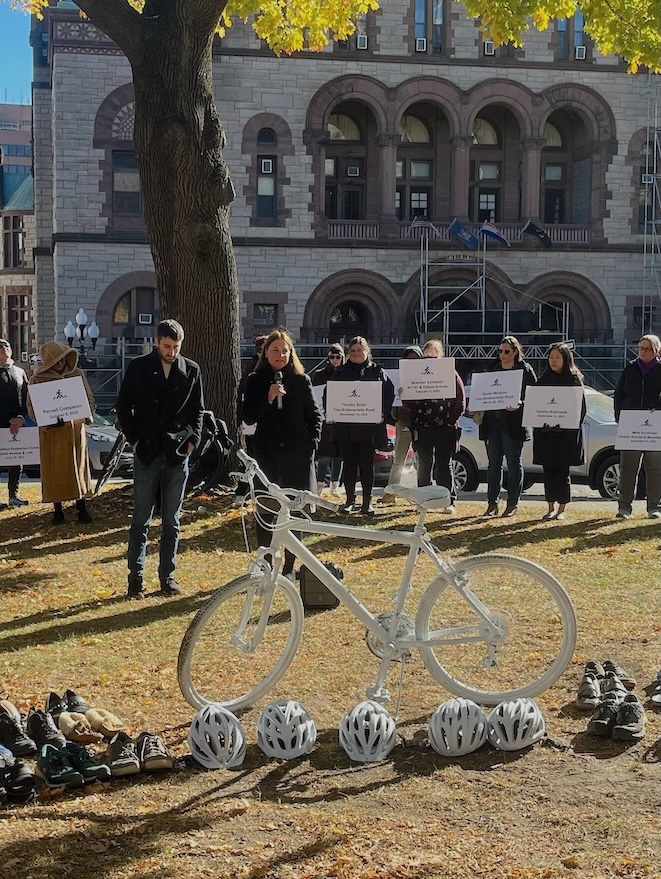
In November of 2024, at our commemoration for the World Day of Remembrance for Victims of Traffic, Albany Bicycle Coalition, Capital Streets and Walkable Albany joined in calling for an Albany County law to require motorists to give bicyclists, pedestrians and other vulnerable road users 3 feet of space when passing. County legislators Susan Laurilliard and Sam Fein joined us at the event which we hold each year to remember County victims of traffic violence. They committed to bringing the 3 foot safe passing bill to the County legislature.
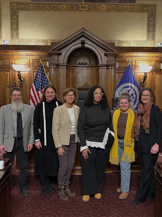
It took 14 months, for the proposal to work its way through committees, amendments and hearings. On February 24th a public hearing was held on the proposal. Ed Brennan, President of Albany Bicycle Coalition, Anne Savage, Executive Director of the New York Bicycling Coalition and Casey Allen, Communications Director of Capital Streets spoke on behalf of the proposal to the legislature. Video of their 3 minute testimonies can be found here. On March 9, 2026 the County Legislature voted 37 to 1 to make this County Law. It will go into effect when it is filed with the Office of the Secretary of State.
It is important to note that the law is meant to be educational. We don’t expect police to be measuring the distance from cars to pedestrians and bicyclists with yardsticks. It is doubtful anyone will be charged unless they actually hit a vulnerable road user. We do want to see signage, as is found in all the state’s surrounding NY, that remind drivers to keep a safe distance from the bodies of vulnerable people that they are blasting by in projectiles that increasingly weigh 2 or more tons.
The long-term goal is for the State of New York to join the 41 other states and the District of Columbia in passing statewide defined safe-passing legislation. The bill has passed the Senate but has repeatedly failed to pass out of the Assembly Transportation Committee. We are hopeful that if enough counties pass laws, the state legislature will need to pass a statewide law for uniformity. Albany County joins Suffolk, Monroe and Ulster County as the 4th NY County with a defined safe passing law. Cortland County has a proposal pending and we hope it will be the 5th County in a few weeks. We encourage our friends in neighboring Schenectady, Rensselaer, Saratoga and Greene Counties to join in this effort.
Full text of the new County Law can be found here.
Albany Bicycle Coalition sent the following email letter to the Town of Bethlehem and NYS Dept. of Transportation (DOT) on March 12, 2025. The area under discussion can be seen in Google satellite view.
The new Blessing Road multi-use path is scheduled to be extended this spring, to the Slingerlands Bypass Route 85 traffic circle. We applaud the work of the Town of Bethlehem to build the multi-use path along the length of windy and narrow Blessing Road, which will separate pedestrians, joggers, and cyclists from obvious traffic dangers. However, Albany Bicycle Coalition has some serious concerns about the safety of cyclists and pedestrians who reach the southern end of the path and then attempt to continue further. If the path simply comes to a sudden end at the traffic circle, leaving users to fend for themselves, it would be worse than the Watervliet multi-use path at 23rd St which crosses the I-787 ramps. In October 2024, a young woman cyclist was struck and killed trying to cross a ramp there. Whatever design decisions are made now may determine whether a similar tragedy happens here in Bethlehem.
A) Traffic from Albany approaches the traffic circle at 55+ mph. Although the posted speed limit drops to 45 mph a few hundred feet before the circle, this is still far in excess of what cyclists and pedestrians are accustomed to. Traffic is very heavy at all times of day. B) The speed limit from Maher Road to Blessing Road is 45 mph throughout. In reality, speeding through a traffic circle at 45 mph is inherently unsafe. C) Although there are small yellow “15 mph” advisory signs near the circle, they are not prominent. Based on observing actual motorist behavior (absent oncoming traffic), they are either ignored, or not even seen. D) Crosswalk markings within the traffic circle are obscured by the “YIELD” text plus large directional arrows in every lane. It’s a visual jumble; to motor vehicles, the crosswalks are essentially invisible. E) The design isn’t a typical “roundabout.” The route from Delmar to Albany is mainly straight. Combined with two lanes throughout the circle, this encourages drivers to speed right through and even accelerate as they pass over the crosswalk. F) Bethlehem motorists bound for Albany are mainly concerned with avoiding other cars. When accelerating out of the circle, there is not enough time to notice people using the crosswalk; and there’s not enough space for a vehicle to stop without being rear-ended. G) Driving to Albany, the circle has two lanes with the option to go straight; they quickly merge to one lane after passing over the crosswalk. A distracting high-speed merge dance occurs exactly where drivers need to pay attention to the crosswalk. Current signage approaching the circle from Delmar tells drivers that both lanes can be used for Albany – which exacerbates the merge situation. H) There are no traffic control signals of any kind, anywhere in the area.
There are numerous design improvements that could help reduce the dangers. Here is a suggested list, ordered from basic and cheap (lower speed limits), to long term (a new bike-pedestrian bridge). 1) 30 mph speed limit approaching the traffic circle. Most drivers – but not all – voluntarily slow down. New speed limits would thus not be an imposition. It would simply require a few new signs, and approval by DOT (NYS Department of Transportation). This is also key for options #4 through #7 below. 2) Revise the lane signage approaching from Delmar. Left lane should say: Blessing Road Only. Right lane should say: Route 85 Only. Currently, Albany-bound cars jockey for position in both exit lanes – which makes it basically impossible to pay attention to the crosswalk. Proper signage would encourage merging in advance. 3) Relocate pavement’s directional arrows and/or “Yield” text. Currently the crosswalks are functionally invisible to drivers in a standard sedan; arrows, crosswalk, and “Yield” are so crammed together that visually they are indistinguishable. 4) Modify the exit lanes heading for Albany. Currently the exit from the circle is a straightaway, over the crosswalk to the 55mph zone. Instead, the exit lanes could be redesigned to have enough angle/curvature to discourage speeds over 30 mph. This may also require increasing the overall diameter of the circle. Those steps could even make it possible to eliminate the left exit lane bound for Albany, so that all merging takes place prior to the circle and within it. Other traffic calming methods could be employed here as well, such as a raised crosswalk or textured pavement. 5) Extend the safety island further northeast and move the east crosswalk further away from the circle. Staggered crosswalks are an engineering design that addresses the queuing space and driver attention problems of crosswalks at traffic circle exits. 6) Pedestrian-activated flashing crossing lights. These “Rectangular Rapid Flashing Beacons” (RRFB) are another standard approach when multi-use paths cross a major traffic artery. Note that this would only be effective if posted speed limit signs were lowered (item #1 above). As noted above in “C,” the small 15 mph advisory signs are not effective; only a standard black-on-white rectangular speed limit sign will get drivers’ attention. 7) Dynamic speed display signs. “Your Speed” electronic displays have been shown effective in slowing drivers down (e.g. NHTSA report). This would be done in conjunction with lower speed limits (item #1 above). Such signs could be installed permanently, or at least during the transition period.
Any of the above would help address an inherently unsafe situation in the short term. Ultimately however, the following should be the long-range plan: 8) Dedicated bike-pedestrian bridge. Precedents exist for such a bridge: (1) bike-ped bridge over Albany Shaker Road near the airport (Google Maps Street View); (2) the well-known rail trail bridge over New Scotland Road in Slingerlands. A bridge would not be feasible by this summer. However, it would be transformational for the entire area, and thus deserves ongoing effort. * A bridge would enable a truly-safe route – for all ages and abilities. * It would be key to a long-distance cycling network – something the Town, County, and CRTC have worked towards for years. It would instantly supply the missing link for a long-distance cycling route from southwest Albany, all the way to the Albany County Helderberg Hudson Rail Trail, for both commuters and recreation (potential route on Google Maps). (Details: begin at Russell Road; continue along the Blessing Road path; cross Route 85 on the new bridge; continue over an existing bike-pedestrian bridge south of the circle, which also accesses the boat launch recreation area; along a gravel road to New Scotland Road; New Scotland Road to Thackeray Drive; local streets to the upcoming Cherry Avenue multi-use path; conclude at Albany County Rail Trail.)
Do the Town of Bethlehem and DOT have existing plans for making the traffic circle area safe? Are funds currently allocated for implementing safety features? What do you think of the potential design improvements that we suggested above?
Every November, Albany Bicycle Coalition participates in the World Day of Remembrance for Victims of Traffic Violence. We meet in front of City Hall to commemorate bicyclists and pedestrians who lost their lives in our region. Our hope is to avoid adding any further names to that list.
Please feel free to contact us to further discuss options and plans.
Ed Brennan, President Albany Bicycle Coalition
Chester Bennett, vice president
Mark Maniak, secretary
Glenn Sandberg, designer CapitalNYBikeMap.com
The Bottom Line – If New Yorkers want safer streets, they are going to have to “stand up and be counted” against those forces that – knowingly or otherwise – stand in the way of this goal.
The Backstory – Once, a long time ago, the statewide municipal speed limit was 25 mph. The highway limit was 50. Somewhere along the way to our present state of roadway mayhem, the municipal limit was raised to 30 and the highway to 55 (1974). Remember? Somehow the “traffic engineers” decided that if we were killing people at 25, why hesitate to go to 30? Aren’t people in a hurry to get somewhere? But wait! “Results show that the average risk of severe injury for a pedestrian struck by a vehicle reaches 10% at an impact speed of 16 mph, 25% at 23 mph, 50% at 31 mph, 75% at 39 mph, and 90% at 46 mph. The average risk of death for a pedestrian reaches 10% at an impact speed of 23 mph, 25% at 32 mph, 50% at 42 mph, 75% at 50 mph, and 90% at 58 mph.” National Association of City Transportation Officials will tell you the same thing. This is the AAA speaking, probably one of the organizations that, of any, backed the “all cars-all the time” situation in which we now suffer. Would you want to guess what the average actual speed is in 30-mph zones?
What We’re Doing – Albany Bicycle Coalition (ABC) is part of the statewide Safe Streets Coalition that pushed for the 25-mph legislation. It passed last year, 2022. ABC worked with the bill sponsors to coordinate the campaign to get passed. It was part of the set of bills called the Crash Victims Rights and Safety Act (CVRSA) that was regularly discussed at ABC meetings. ABC members made calls and wrote to State Legislators and the Governor, participated in a Lobby Day at the Capitol, and spoke before the Assembly Transportation Committee. ABC was successful in getting Albany City Common Council to unanimously pass a resolution in support of the CVRSA. Other cities and towns followed. Three of those CVRSA bills passed including the 25-mph bill.
The 25-mph law was a victory, but it was tempered with a late amendment placing substantial barriers in the way of implementation. This same mentality is also the reason we still don’t have a 3-foot safe passage law for cyclists as is the case in 36 other states and the District of Columbia.
The Cities Speak – After the bill passed Albany, Troy, Schenectady, Bethlehem, and Saratoga Springs all started to pursue lowering their speed limits. We are following their progress and need to be ready to speak out when these ordinances are ready for public comment. In the meantime, there is great confusion about what is required to meet the hurdle of the language below. We hope that the Capital District Transportation Committee (CDTC) will hold a webinar to help everyone contend with it all the barriers to this critical, “safety-first” speed limit.
ABC and other Safe Streets members are concerned about the lack of clarity on how to proceed to 25 mph. We ask – why not base the speed-reduction ordinances on these factors?
Rate of fatalities and injuries.
Existing studies (e.g., the data already in Albany’s Bicycle/Pedestrian Master Plan).
Increasing prevalence and deadliness of larger vehicles.
Increasing statewide traffic violence (e.g., all traffic fatalities in NY up another 4 percent in first 9 months of 2022).
In the meantime, we are waiting for regulations. If they are not satisfactory, we will probably seek a new amendment to the statute.
Act Now – This year ABC is joining with the Safe Streets Coalition in pursuing the bills that can be found at https://www.transalt.org/safe. The collection of bills is called the Safe Streets Act (instead of the Crash Victims Rights and Safety Act). You can help by following the link and then clicking on “Take Action Now for Safe Streets”. It will help you auto-generate a message to your NYS Senator and Assembly Member. You can edit the message to include your comments about the current 25-mph bill!
You can also help make streets safer locally by spreading word about the Capital Region Vision Zero Alliance. This Alliance is taking the effort for safer streets beyond bicycle and pedestrian groups. We aim to diversify, coordinate and amplify the demand for the tried-and-true changes we need on the local level. We want to bring in organizations concerned with public health, crime, safety for our young and old, and even AAA – anyone concerned with safe roads.
Barriers – This is the Infamous language (the complete source appears below) included in the 25-mph law: “No speed limits shall be established pursuant to the provisions of this section except in accordance with the engineering considerations and factors for speed limits set forth in the manual and specifications for a uniform system of traffic control devices maintained by the commissioner of transportation pursuant to section sixteen hundred eighty of this title, as such manual and specifications may be amended from time to time, certified by a licensed professional engineer who specializes in traffic operations.”
This is a gross misunderstanding of the intent of the law and its implementation. The 25-mph law needs to be a political and societal decision based on the safety needs of all road users and not a technical/engineering one based on outmoded priorities and dated expertise. It is absolutely insane that cities cannot determine the best speed limit in certain area. Thirty mph on narrow, one-way streets is too fast as it is on many residential and commercial areas. If imposition of the 25-mph limit is contingent on a traffic study, cities, such as Albany, will delay movement on 25 mph waiting for the study. They have no choice.
But It’s Worse – In spite of NYSDOT abysmal design-for-death practices, it is empowered to interfere in almost any aspect of establishing 25-mph limits. According to the following, the NYS Legislature has again ignored NYSDOT’s past and current road design debacles and has re-empowered it to squelch any but the most strident safety advocates or municipalities. With DOT’s grip on the purse strings and with its power to frustrate almost any road/street project. It seems to hold all the cards in what is really only a baby step toward equitable road design.
Learn More – Here are some links for those who are genuinely interested in roadway safety and who are fed up totally with the “all cars-all the time” philosophy that drivers urban “traffic planning:”
Guidance on Implementation of 25-mph Speed Limits from New York State Department of Transportation – October 19, 2022 – Office of Traffic Safety & Mobility
Washington Ave. Flyover – A Call for Change – In fall 2012, the long awaited “Flyover” to route through motor vehicle traffic from Washington Ave. to the Washington Ave. Extension was completed. This and the accompanying series of traffic circles on Fuller Rd. were clearly designed under an “all cars-all the time” philosophy. These means that people on bicycles who want to travel on Washington Ave. and its Extension, on Fuller Rd., on the University at Albany’s “purple path,” and on the Six-Mile Trail must be in the Advanced/Experienced “Strong and Fearless” or “Enthused and confident” 1 percent category.
The following letter calls for the New York State Department of Transportation to revisit this area and to modify it to accommodate people on bicycles.
Sam Zhou, PE – Director
Region One – NYS Department of Transportation
50 Wolf Road
Albany, NY 12232
Dear Mr. Zhou:
This is to seek your assistance in clarifying safety concerns of the Albany Bicycle Coalition and of people on bicycles who use Washington Ave., Washington Ave. Extension, and Fuller Rd.
Because of our advocacy role in the region, we receive questions and comments about riding conditions. One common area of concern is navigation of the Fuller Rd. traffic circles, the Fuller Rd./Washington Ave. intersections, the Flyover, and bicycle travel on Washington Ave. Extension. As you are aware, fear of riding in traffic is the single, major impediment to bicycle travel. This is nowhere more apparent than in those spaces where motor vehicle movement was the paramount design feature.
In response to these concerns, we formed a study group to develop questions and recommendations about these specific roadways. We are at the point where we need advice from you or members of your staff on what are feasible treatments for this Washington Ave.-Fuller Rd. area.
I am asking that you arrange for our group to meet with you or staff for a learning session where we can articulate our concerns and our ideas. I am enclosing some specific ideas that result from our site visits and deliberations. Because several of our members work during the day, it would be helpful to have such a meeting at the end of or after the businesses day. This meeting could be augmented by site visit(s).
We look forward to hearing from you.
++++++ Attachment ++++++
ALBANY BICYCLE COALITION, INC.
SPECIFIC RECOMMENDATIONS ON FULLER RD./WASHINGTON AVE. FLYOVER
September 2018
Bicycles Ahead Signage – Place several signs near the merge areas on both Fuller Rd. and Washington Ave. (Share the Road, Bicycles In Lane, etc.). Of particular emphasis is the on ramp to westbound Washington Ave. Extension from southbound Fuller Rd.
Bicycle Lane Markings – Install conventional bicycle lane pavement markings on the Washington Ave. “flyover” shoulders to designate clearly where the people on bicycles should be riding. These markings will instruct both cyclists and people in cars.
Bicycle Lane – Install “Bicycle Lane” signs near and at both entrances to the Flyover.
Activation Alert – Install bicycle-activated sensors to illuminate a bicycle symbol sign on the Fuller Rd. exit onto westbound Washington Ave. These will alert motorists when cyclists are present. Bicycles would activate these as they pass over the correct place on the shoulder (bicycle lane) without stopping. (A less effective alternative is MUTCD-compliant flashing LED edge-light signs with high-intensity LEDs.)
Intersection Crossing Pavement Marking on Westbound Washington Ave. – Install crossing markings (e.g., dotted green and white) in the median to guide people on bicycles from the proposed bicycle lane on westbound Washington Ave. to the proper lane to continue west on Washington Ave. Extension. This will (1) alert people in cars to the presence of bicycles and (2) guide cyclists away from the tail of the merge lane (where they would risk conflicts with both the through motor vehicles and the merging motor vehicles).
Shared Lanes Markings – Install Shared Lanes pavement markings on all lanes leading to and from the flyover.
Walk Your Bicycle Assist – Install enhanced walking instructions for those people on bicycles who prefer not to navigate by bicycle the multiple traffic circles to access the Six-Mile Trail, Washington Ave., the University at Albany campus, or Fuller Rd. Ensure continued diligence to maintain and clean the sidewalks, curb cuts, and pavement markings/signage.
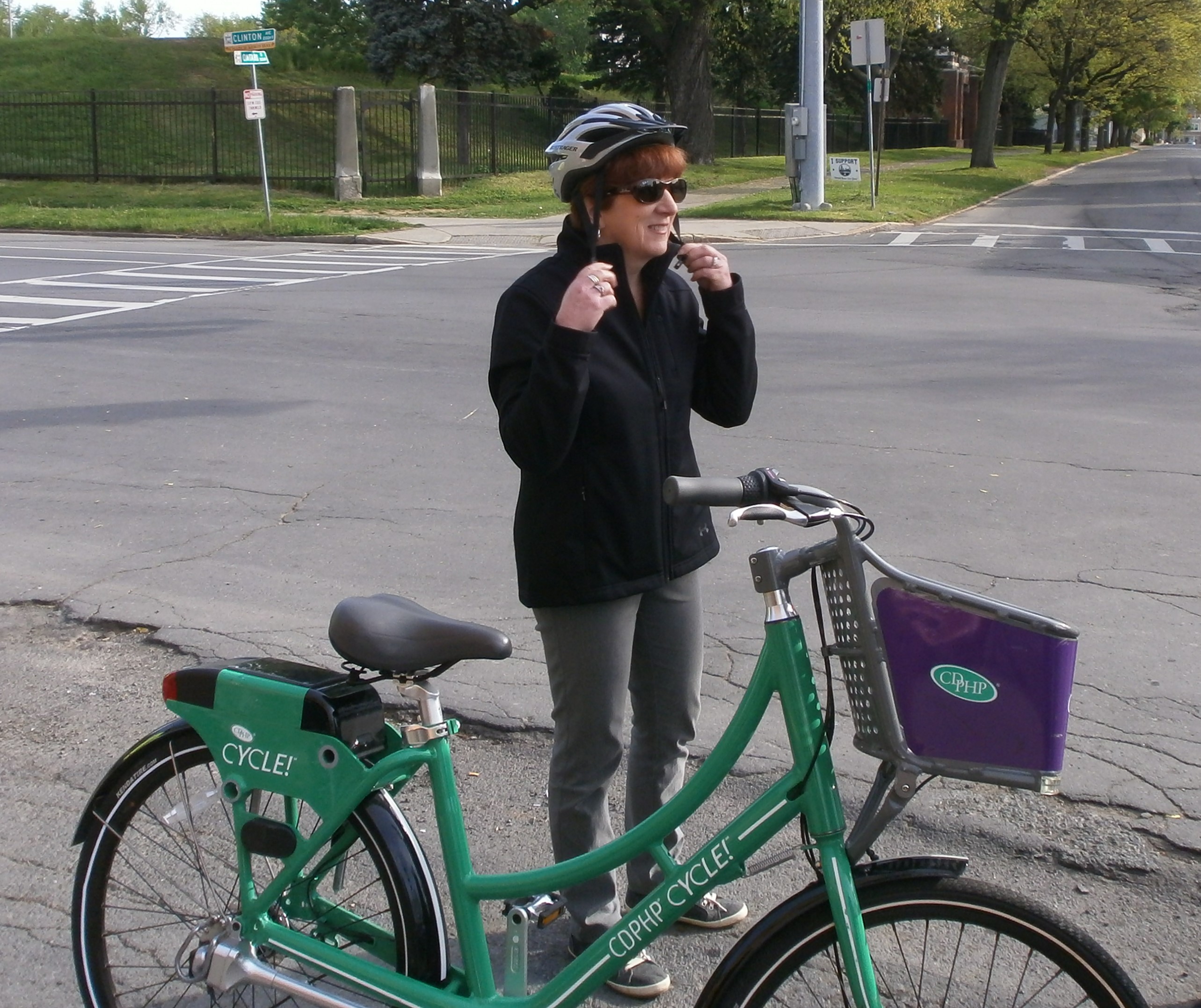
Friday, 5/18, 8:00 AM – Mayor Sheehan Ride to Work Day – A group of riders, guarded by a phalanx of Albany Police Department Bicycle Officers, joined Mayor Sheehan for a “ride to work.”
The commute began at 8 AM at the corner of Ontario St. and Clinton Ave. (across from Albany Fire Department #7) and went down Albany’s paramount bicycle lanes on Clinton Ave. and then go right on Broadway to Stacks Espresso Bar, where Mayor Sheehan generously treated us to coffee, tea, and other beverages.
The Mayor and several others road CDPHP Cycle! BikeShare bicycles – a great way to promote the service that features 40 racks in the City of Albany and with 160 new bicycles slated for installation in June.


 The commute began at 8 AM at the corner of Ontario St. and Clinton Ave. (across from Albany Fire Department #7) and went down Albany’s paramount bicycle lanes on Clinton Ave. and then go right on Broadway to