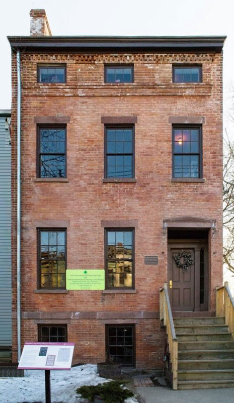
Stephen and Harriet Myers Residence – Underground Railroad House
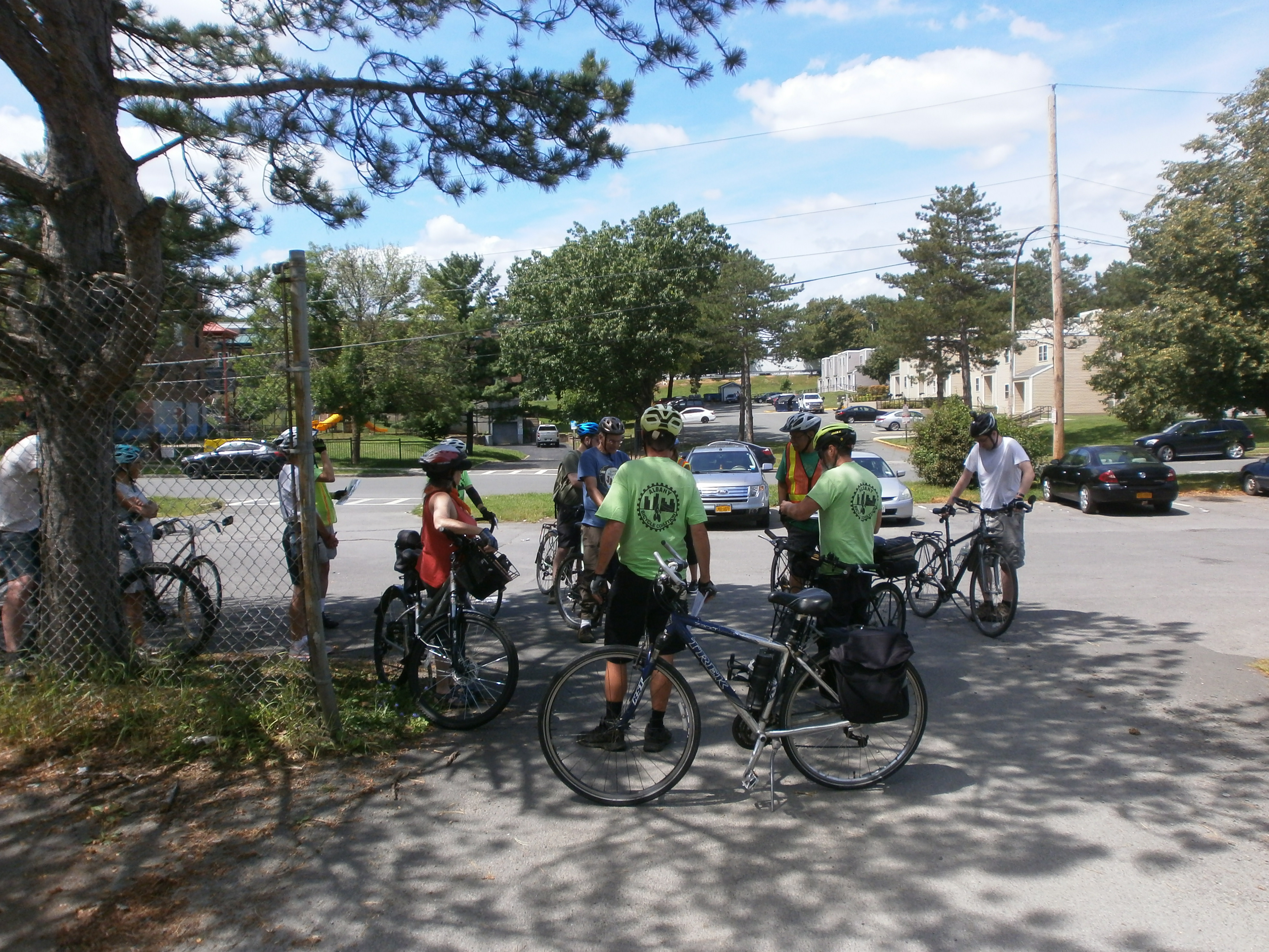
Getting Ready to Ride
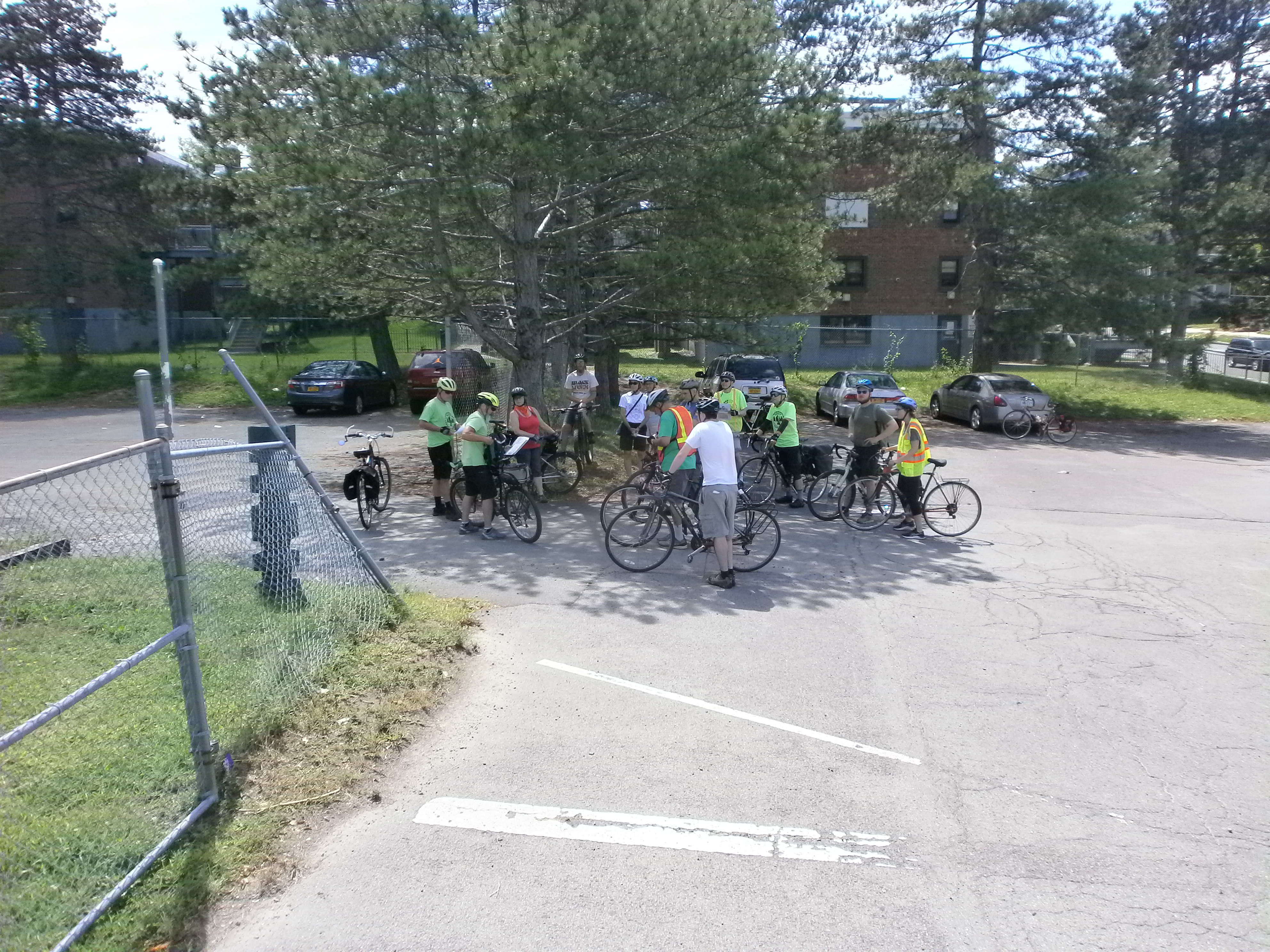
On the picture perfect Sunday afternoon, August 15, the Underground Railroad Education Center and the Albany Bicycle Coalition jointly conducted an Arbor Hill/West Hill “Slow Roll” bicycle ride (see stats at end of this post). The fun, safe, low-stress, low-speed bicycle ride took advantage of numerous bicycle lanes, trails, and low congestion streets in the neighborhood. The group stopped at several points where speakers led discussions on the history and future of the neighborhoods. Stops included the Harriet and Stephen Myers Residence, Arbor Hill Park, Tivoli Lake Preserve, Bleeker Stadium/Swinburne Park, and the Arbor Hill Library. The Tivoli Preserve stop highlighted the 9-mile Patroon Creek Greenway Trail currently undergoing study by the City of Albany (see http://albanyny.gov/800/Patroon-Greenway-Feasibility-Study). The new Greenway Trail would connect the Albany Waterfront to the Six Mile Waterworks and points beyond with access from Arbor Hill and West Hill. We also discussed the daylighting of the Patroon Creek and making nearby mountain bike trails more accessible to Tivoli Preserve and its adjoining neighborhoods.
Stephen and Harriet Myers Residence
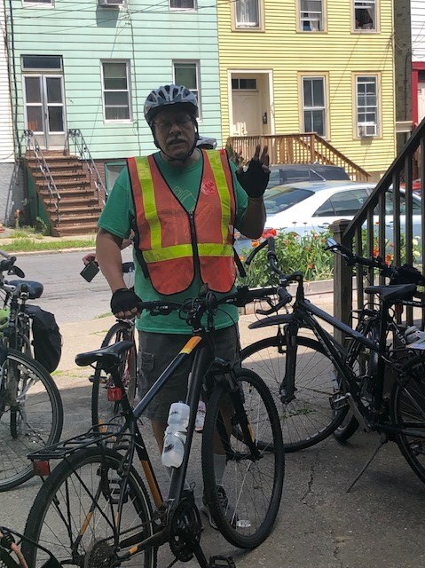
Paul of the Stephen and Harriet Myers Residence at the Start
Assembling the Ride
Arbor Hill Park -1
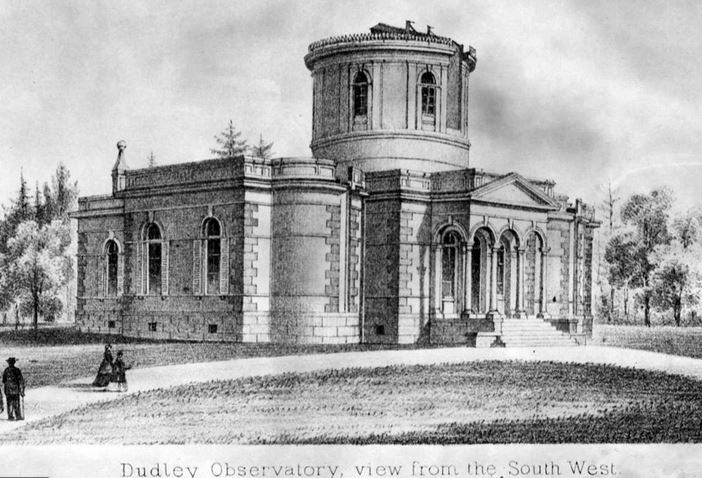
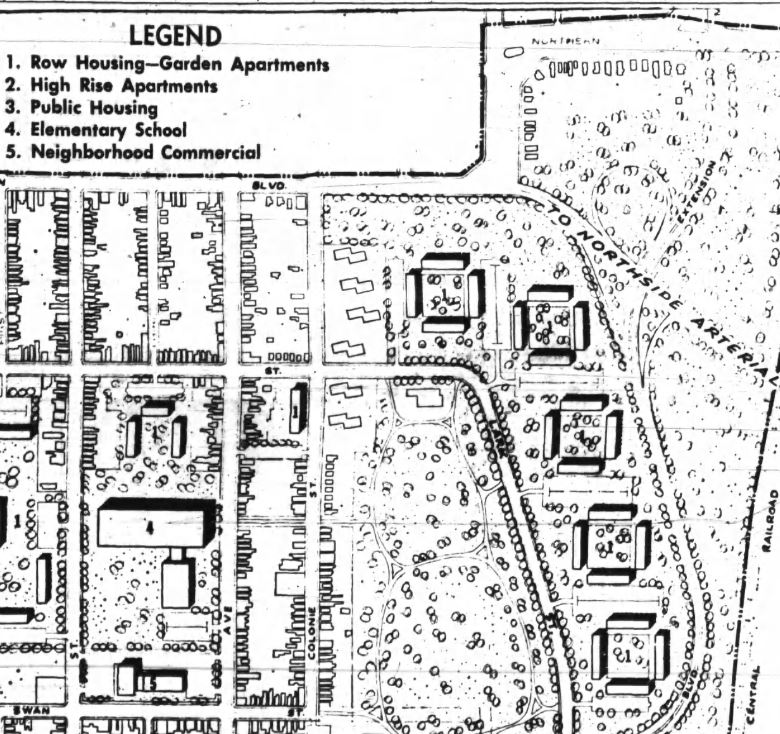
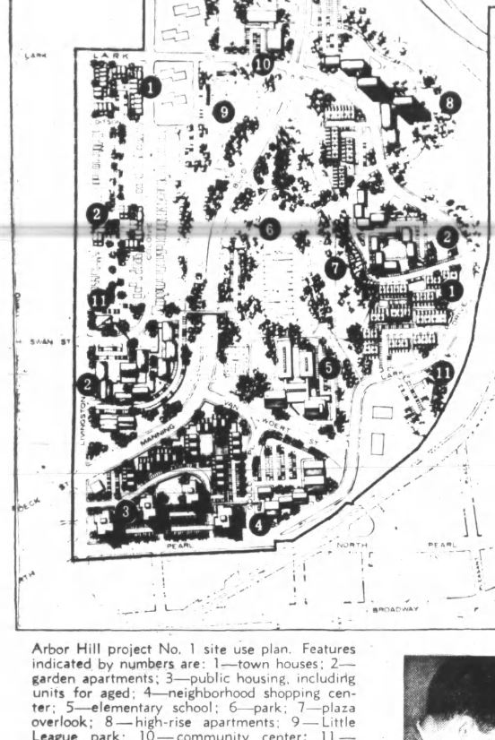
Our Arbor Park Stop pointed out the nearby site of the original Dudley Observatory. We also noted 1962 Urban Renewal Plans for the area that would have put a school where the historic Harriet and Stephen Myers Residence still stands. The 1964 plans are more representative of the current configuration.
Arbor Hill Park Was Once Site of the Dudley Observatory and Park
Proposed School (See #4) on Site of Stephen and Harriet Myers Residence
A little history lesson . . .
Arbor Hill Park – 2
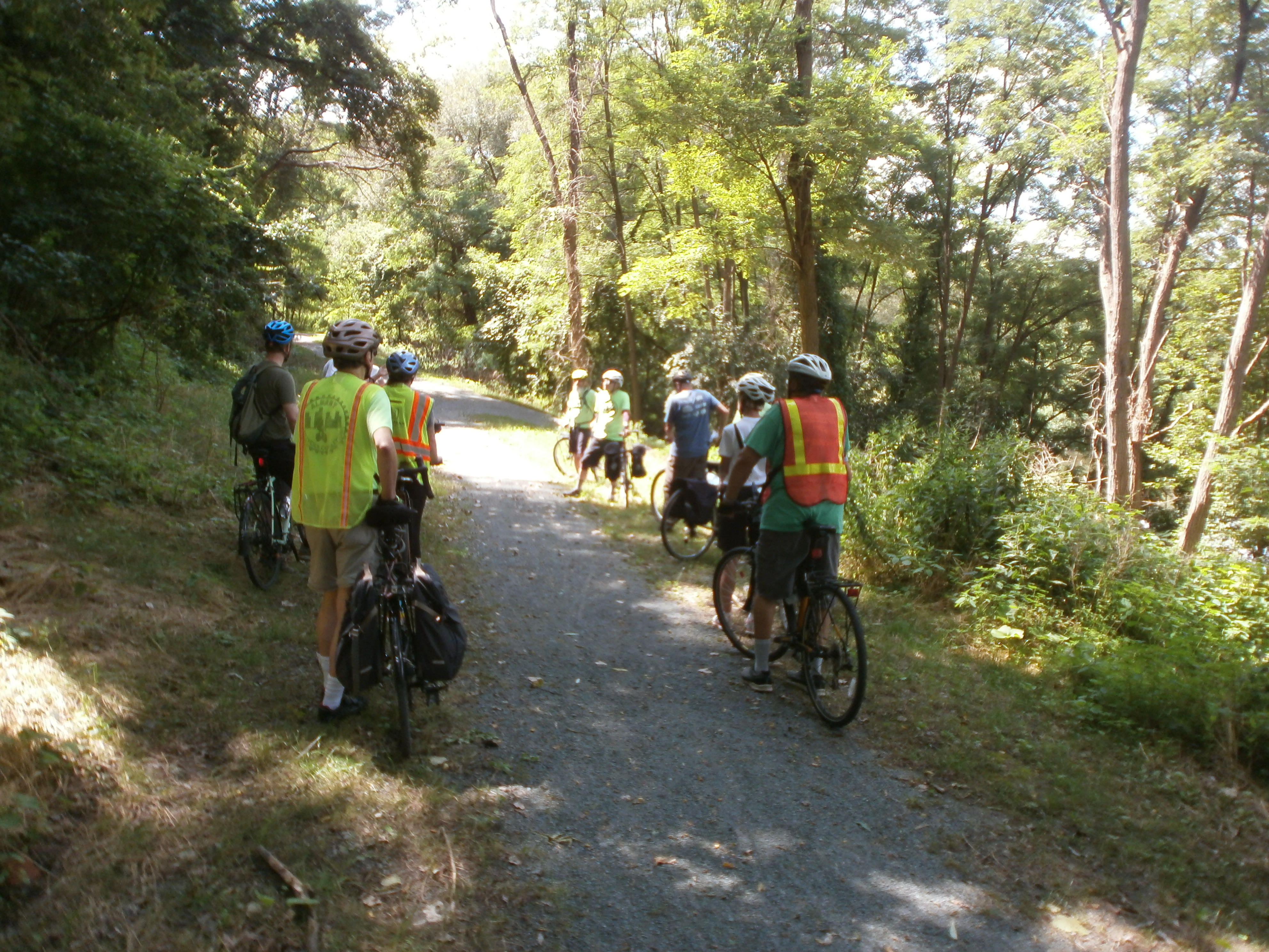
Tivoli Lake Preserve – 1
Tivoli Lake Preserve – 2
Rider in the Preserve
Patroon Greenway Project
Surprise! Street Fair
What Albany’s Library Does for You
Ride End at the Stephen and Harriet Myers Residence Underground Railroad
RIDE STATS – The ride covered 4.37 miles “door-to-door” and started at 1:15 and ended at 2:45 (1 hour 30 min) with 44 min of actual riding with an average speed of 5.7 mph. The ride thus met its goal of being a “slow roll” that riders of all abilities could enjoy.
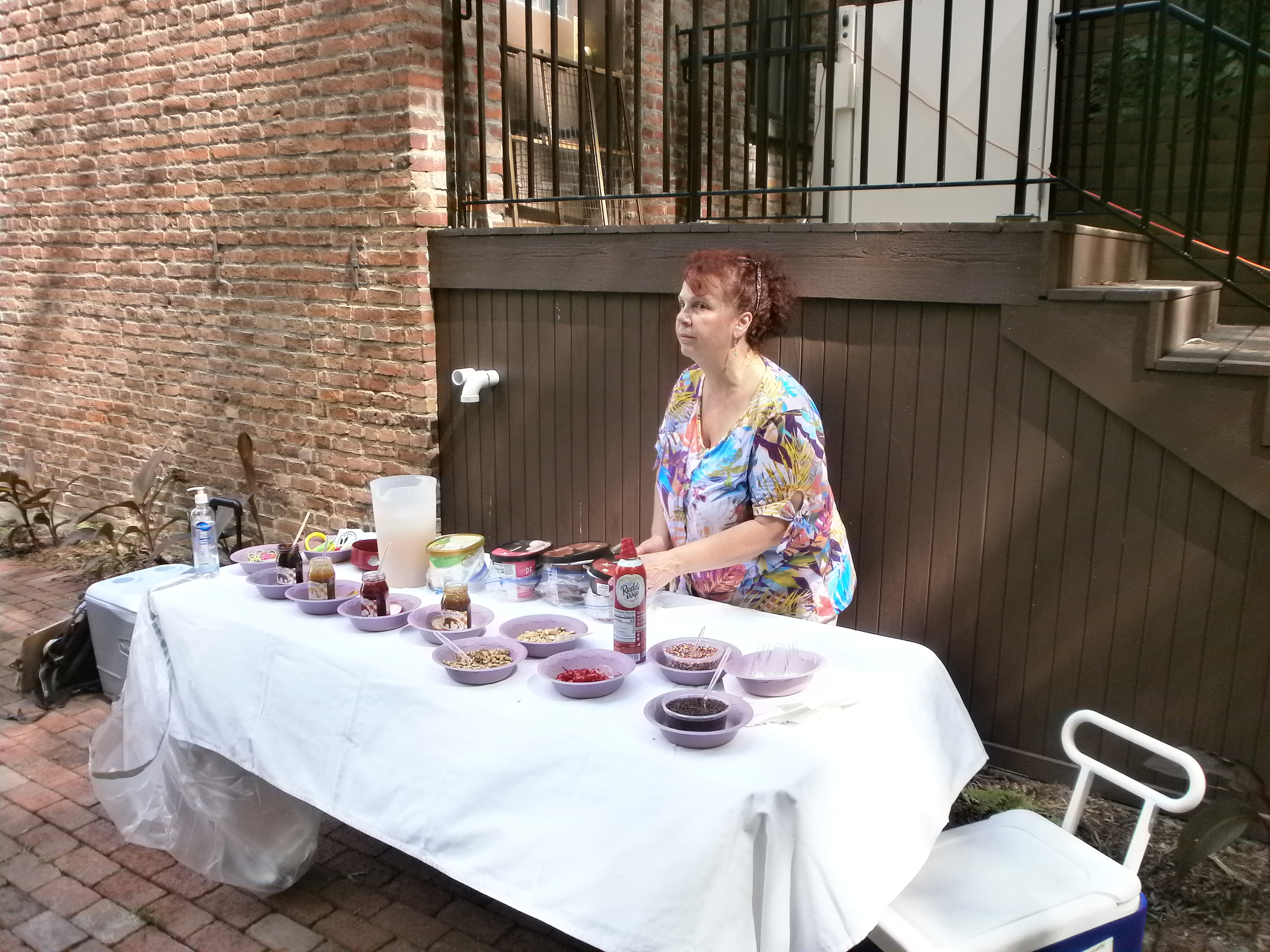
What a Reward! – Ice Cream Sundaes on a Hot Day
We ended the ride with an “ice cream social” in the shady back yard of the Stephen and Harriet Myers Residence.
The Albany Bicycle Coalition will be conducting a “Bike the Branches Slow Roll” in conjunction with the Albany Public Libraries on September 25.
On May 19, 2021, seventeen riders commemorated the annual Ride of Silence to honor those injured or killed while riding their bicycles. Following the international standard of the third Wednesday in May, riders toured the four ghost bike sites within the city of Albany. The list of four riders we honored appears below in the order visited.
The Ride – The Albany Bicycle Coalition has planned and hosted this ride since 2008 – with the exception of 2020. After consultation with the Albany County Department of Health and other sources, we redesigned the ride to conform to COVID-19 safety standards and to ensure that riders enjoyed safe routes. This year’s changes included the following:
To facilitate COVID-19 safety, we required pre-ride registration and set out specific procedural steps (e.g., masks, social distance).
We developed a new route so that, with the cohort monitors, even traffic-adverse riders could join without hesitation.
Non-riding ABC staff displayed 2X3 foot posters at each ghost bike site showing the first name, date of death, and a bicycle symbol.
We posted a small weather-resistant sign at each site as in past years.
The ride was split into cohorts with a maximum of 10 riders each accompanied by a skilled ride leader and a “sweep” to assist any riders who fell out of the ride.
Rather than stopping at each of the four sites as in past years, we merely rode slowly by.
The ride was 13.9 miles long with 650 feet elevation gain.
We offered two starting locations so riders who chose to do so could avoid climbing the hill from the Hudson River level.
As in years past, each rider received a flyer listing all the local ghost bike cases with a factual summary.
Ghost Bike Summary – About one-half those listed on our handout were the fault of people in cars (54% -Cummings, Agne, Ratalle, Merges, Melnikoff, Zayhowski, and Ryan) vs. rider or both driver/rider (15% – De Loyaza, Richichi), and unknown (31%). In 10 out of the 31 bicycle fatalities listed by the Albany Bicycle Coalition, drugs, and alcohol use by the motor vehicle operator was a contributing cause.
Ghost bikes in the City of Albany remained undisturbed until early 4/2014 when the Department of General Services removed them.
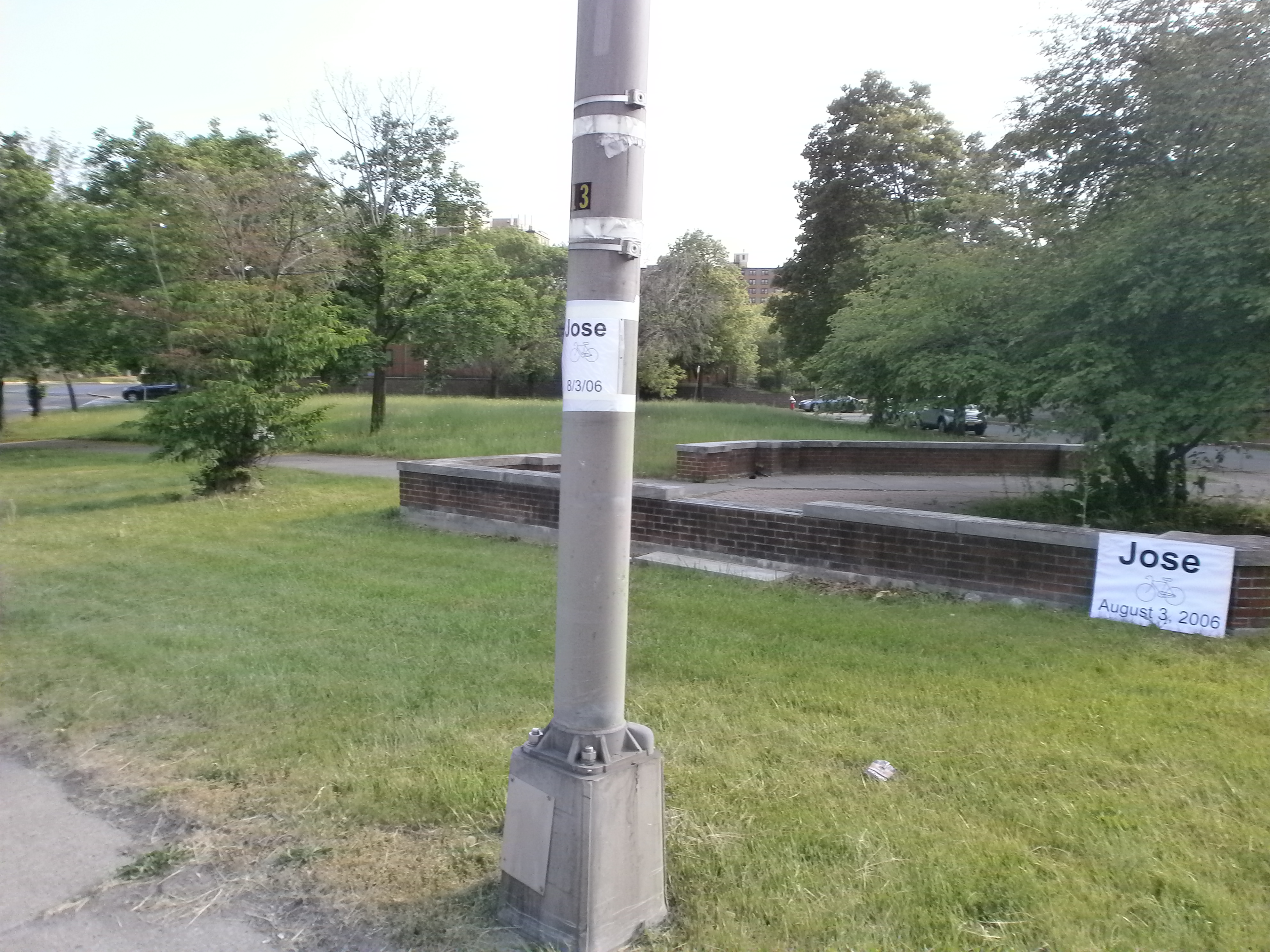
Jose Perez – August 3, 2006 (age 60) Bicyclist killed by SUV, Broadway at Quay St., Albany. Perez, who was dealing with liver problems, did not own a car, and used is bicycle to get around, often taking rides at the Corning Preserve bike path along the Hudson River. Dusk was falling at about 8:30 PM when Jose crossed into traffic near Quay St. and Broadway. A sport utility vehicle heading north could not stop and struck the cyclist head-on. Perez was pronounced dead at the scene. Some few days after the installation of Jose’s ghost bike, his sister left this note attached to it: “Attention: I greatly appreciate those who made this memorial in remembrance of my brother José Perez (Ray) I would very much like for you to contact me via cell phone _____ My name is Nivia. Thank you” Jose’s ghost bike was the first of many installed in the City of Albany. The city removed all the ghost bikes in 2016.
OLYMPUS DIGITAL CAMERA
Diva De Loayza – June 6, 2007 (age 40) Bicyclist killed by car, Western Ave. at Homestead Ave., Albany. A motor vehicle operator made a left turn into University Place from east-bound Western Ave. and struck and killed Diva who was riding her bicycle west in the University Place crosswalk. Diva operated the “Some Girls” boutiques in Troy and Utica. For many years, store employees came to the ghost bike site during the ride. They also decorated her bicycle for Christmas, etc.
Paul J. Merges, Jr. – November 24, 2012 (age 45) Bicyclist killed by drunk driver, Manning Blvd. & Roosevelt St., Albany. Paul was returning home after visiting his daughters. The driver, Pablo Cruz, a drunken driver, ran Merges down on 11/24/12 in a gruesome 51-mph collision. A sheriff’s deputy was pursuing Cruz at high speeds through city residential streets at the time. Cruz, 39, had been released from prison on a drug charge less than four weeks before the crash. Cruz was accused of then driving 12 miles with Merges’s body pinned to the roof rack of his truck. He was caught in Rotterdam after his truck engine failed. Cruz received 25 Years to Life for second-degree murder, vehicular manslaughter, and felony leaving the scene of an accident, reckless endangerment, and reckless driving. He said at sentencing, “Nah, I’ve got nothing to say.”
Edston J. Kirnon – July 22, 2017 (age 42) Bicyclist collided with side of CDTA bus, N. Pearl St., Albany The fatality at Pearl and Wilson was not the fault of the bus driver. All the available data, plus an assessment of the location, indicate that the cyclist did not have control of his bicycle going down a steep hill, and ran the stop sign. The bus driver was so distraught she could not continue driving.
On 2/20/21, the Albany Bicycle Coalition sent a follow-up letter to Mayor Sheehan on a number of proposals that we submitted between 2016 and 2020. It is our position that each of these – albeit each with a primary focus on cycling – would add immeasurably to the safety, convenience, ambience, and economic vitality of the city regardless of their benefit for people on bicycles. Each project stands on its own merit in this regard.
February 20, 2021 RE: ABC Initiatives – Various
Dear Mayor Sheehan:
Over the last several years, the Albany Bicycle Coalition proposed a number of projects to enhance the value of our community to all its residents and to those who visit or work in the City of Albany. I would like your assistance in tracing down the status of these proposals with in the city. The base document for each item is attached for your reference.
South End Connector Safety Modifications (11/14/20) – One of the safety issues – the intersection of the South End Connector with Church St. and Broadway is of long standing. We were surprised that it remained unaddressed in the final configuration of the Connector. The second safety issue resulted from the new junction between S. Pearl St. and the Connector at the I-787 S. Pearl St. overpass. The city needs to address them both. At the same time we submitted these recommendations, we added some items to enhance the values of the Connector to the “south end” community.
Clinton Ave. Refreshment of Bicycle Lane Pavement Markings (10/12/20) – The benefits of the Clinton Ave. bicycle lanes to residents (traffic calming in a residential area), to people in cars (calmed speed with fewer wrecks) and to people on bicycles (easy climb “up the hill” and safety will only be maximized if the lanes are maintained so they are visible to all.
New Scotland Ave. Major Bicycle Commuter Route (4/18/20) – Again, New Scotland Ave. would jump to the top of any list as a major commuter route for people on bicycles as it connects many residential areas to places of employment or service along it. The section from Manning Blvd. to Bethlehem is the singular route for cyclists and is blessed with room for superior bicycle facilities for much of its length. Additional, those who participated in the traffic study were clear in their desire for traffic calming.
Western Ave. Traffic Calming (7/21/19) – As in the 2009 Albany Bicycle Master Plan, the November 2020 draft of the new Albany Bicycle/Pedestrian Master Plan calls for Western Ave. to be a “major bikeway” with recommended protected bicycle lanes. Regardless, the clear need is to convert immediately Western Ave. into a traffic-calmed street with the same or better treatment as on Madison Ave. There is no evident need to wait for yet another study, as Western Ave. will always bubble to the top of the improvement list.
Albany-Colonie Connector (10/2/18) – Albany Bicycle Coalition is on a campaign for bicycle connections between the various municipalities. We want to develop a network of relatively low-stress, low-traffic routes. The Albany-Colonie Connector is one of our prime goals as it will join the Washington Ave. Ext./Guilderland to the Town of Colonie and Niskayuna and lead to the Mohawk-Hudson Bike-Hike Trail. The route is clear and all it needs is support of the municipalities to embrace it with way finding signage, and repair and bicycle facilities such as bicycle lane and protected bicycle lanes.
Close Washington Park Road to Motor Vehicles (8/26/16) – When the water/sewer repairs on S. Lake Ave. closed the park road along the southwest Washington Park Lake, it was apparent that this road need not be available to people in cars. Closing it permanently would have two benefits: (1) partially returning Washington Park to its park status and (2) preparing the way for more reductions in motor vehicle traffic in the park as part of the proposed Washington Park-Lark St. study.
Mayor Sheehan, as always the Albany Bicycle Coalition believes that it has put forward ideas that will enhance the City of Albany for all street users by adding safety, economic growth, and pleasantness. When we were pushing for protected bicycle lanes on Madison Ave., you once stated to me that “protected bicycle lanes would make it a ‘bicycle project’” vs. a traffic calming project. While we operate under the umbrella of cycling and the needs of people on bicycles, my several years of observing the new Madison Ave. and Clinton Ave. convince me, more than ever, that every one of our projects stands to have benefits far beyond that primary focus.
++++++
#1 – Safety and Access Enhancements to the South End Connector ~ As submitted 9/17/20 to the City of Albany with updates 2/19/21 ~
Multiuse Path Maintenance – the City of Albany Department of General Services was quite responsive to our recent call for mowing and cleanup of the median/divider on the I-787 access/frontage road portion of the South End Connector. The city needs to ensure that this maintenance be a regular part of DGS’s role in the area. Glass in the cycle track will continue to plague people on bicycles.
Signage, Lighting, and Striping at S. Pearl St.-South End Connector Intersection – There is a need for signage and re-striping of the crosswalks and new lighting at the intersection of S. Pearl Street and the I-787 access/frontage road. This would alert people in cars who are making both left and right turns from S. Pearl onto the access road that bicyclists and pedestrians could be using the crosswalks. These are swooping turns that are, unfortunately, plentiful in the City of Albany. Motor vehicles traveling north on S. Pearl make the turn at excessive speed. It is awkward for bicyclists wanting to continue north on S. Pearl to see cars coming from the south. (That is, those who are not staying on the Connector beyond this intersection). Similarly, people on bicycles heading south on S. Pearl St. but wanting to enter the Connector (i.e., a left turn off S. Pearl St.) have difficulty making a safe turn. Pedestrians also have to look awkwardly to their left before stepping into the crosswalk, when heading north on S. Pearl, or their right, when heading south. We raised this issue at the public meetings hosted by the City.
Attention to this intersection (as well as Bassett St. and Broadway/Quay St.) is integral to making the Connector a community/local street asset and not merely a recreational, end-to-end experience. It is part of recognizing that the “South End” needs access to current and future bicycle facilities in the City of Albany.
Pedestrian And Cyclist Entrance/Exit at Bassett St. – To encourage safe access to the Connector and to promote it as a community resource, there needs to be an entrance/exit connecting Bassett St. and the South End Connector. Addition of a striped area (e.g., a green path) could easily accomplish this purpose with the addition a “no entry for motor vehicles” sign.
Enhanced Motor Vehicle Traffic Control at Broadway/Quay St. – This intersection has been a barrier for people on bicycles and people walking since its original construction. This long-standing problem predates the South End Connector by many years and was the site where a motor vehicle operator struck and killed cyclist Jose Perez.
Ghost Buke for Jose at Broadway and Quay
Looking east toward the Hudson River, people in cars swoop off Broadway at high speeds to the right/south. When they make this right turn onto Broadway, they come up on the bicycle rider’s blind side. The only current traffic control is a yield sign. This sign is ineffective since it is clear to a driver that there is no motor vehicle traffic to which to yield. At an absolute minimum, a stop sign should replace the yield sign. This alteration is a small task that could be done in an hour or two at minimal cost.
For guidance for people on bicycles, bright green bicycle lanes (similar to Colonie St.) would help southbound riders coming from the Corning Riverfront Park to see clearly the correct bike diagonally across the street. Bicyclists cannot see the Connector since it is across the intersection under I-787. Prominent wayfinding signs, a map, and green pavement markings would guide riders from the waterfront to South End Connector without mistakenly riding in the street.
It is also unclear as to how bicyclists are to navigate crossing Broadway when either exiting the Connector or the Corning riverfront trail. When the light is red for vehicles traveling north on Broadway, riders coming off the Connector are scanning to their left and rear. Riders exiting the Corning trail have to scan straight ahead and be far enough out of the intersection to clear traffic turning onto the I-787 ramp, often at high speed. (We have even witnessed the running of red lights.) People on bicycles also have to be alert to motor vehicles coming north on Broadway to continue on Quay St. or Broadway into the city proper. This issue was raised at the public meetings hosted by the City of Albany. Overall, we need more demonstrative traffic control and signage at this intersection.
South End Connector Grand Opening Ride
++++++
#2 – Refresh Lane Markings Clinton Ave.
October 12, 2020 – RE: Lane Markings Clinton Ave.
It’s Easier to Smile on Clinton Ave. When We Can See the Bike Lane Markings
Dear Mayor Sheehan:
This is to draw your attention to the need to refresh the bicycle lane markings on Clinton Ave.
Because of its Ten Broeck-to-Manning bicycle lanes, Clinton Ave. is a favored “up the hill” route for people on bicycles. The street also connects directly to the Mohawk-Hudson Bike-Hike Trail and, ultimately, to the Skyway. With the advent of the bicycle lane network in the Northern Blvd. area and the hoped for on-street bicycle link between it and the lanes on Clinton Ave., maintenance of the lane markings on the avenue is critical.
In many areas only ghost images remain. This is especially so at cross streets where traffic scrubbing is heavy. People in cars entering Clinton Ave. need the markings to alert them to the presence of bicycles and people.
Over and above all bicycle and motor vehicle issues, Clinton Ave. with its adjacent streets is essentially residential with people coming and going, children playing, and many enjoying time with neighbors and friends on stoops and sidewalks. For those who remember when Clinton Ave. was essentially a 4-lane superhighway, although unmarked as such, the installation of bicycle lanes in 2008 brought traffic calming to the street. Even so, the route still has unending through- and cross-town traffic. Equity alone suggests that the city have a thorough and regular program of refreshing pavement markings to preserve this major side benefit of bicycle lanes – reduced motor vehicle speeds.
On behalf of people on bicycles and the residents and visitors to Clinton Ave., I ask that you arrange for an inspection and timely remediation of the bicycle lanes.
++++++
#3 – Bicycle Lanes on New Scotland Ave. – Manning Blvd. to White Hall Rd.
April 8, 2019 – RE: New Scotland Ave. – Manning Blvd. to White Hall Rd.
Dear Mayor Sheehan:
We in the Albany Bicycle Coalition are pleased to learn of progress on New Scotland Ave. Traffic Calming and appreciate your attention to this major route through the City of Albany. Even though we understand that this project has a long completion horizon, we would like to offer our comments.
Speaking not only as cyclists, but also in consideration of all users of New Scotland Ave. – pedestrians, motorists, disabled, and local businesses – we fully endorse a complete streets/road diet approach. We believe two motor vehicle lanes, superior bicycle lanes, and appropriate and supportive signalization and signage is the only proper treatment for this road. As you well know, New Scotland Ave. could be a major bicycle commuter route – any effort to Traffic Calm this street will benefit all.
We recommend the following specifically:
That the city install high-quality bicycle lanes for the entire segment. To install other than full-dimension bicycle lanes will lose the traffic calming befit that derives from them (as we know from Madison Avenue Traffic Calming).
That any traffic circles/roundabouts be single lane and not “hybrid” in nature.
That Creighton Manning refine and adopt the “bump out plan” for the New Scotland/Lenox/Buckingham intersection to decelerate people in cars turning from New Scotland onto Buckingham and from Buckingham onto New Scotland Ave. This will reinforce what we understand to be the planned treatment for Quail St./New Scotland Ave.
That between Manning Blvd. and Whitehall Rd. there should be no Shared Lanes for these reasons:
Shared Lanes markings, being in the travel lane and subject to damage by traffic, street sweeping, and plowing will disappear in 1.5 to 2 years. Their modest benefit for people on bicycles then will be lost and motor vehicle traffic will return to the (high) road design speed.
According to NACTO, shared lanes should support a complete bikeway network. They are not a facility type and should not be considered a substitute for bicycle lanes or other separation treatments where these types of facilities are otherwise warranted or space permits. Accordingly, we suggest that as a matter of city policy you never recommend Shared Lanes unless they are part of a planned “bikeway network.”
Shared Lanes might have a place on New Scotland Ave. if we look at the entire Whitehall Rd.-Madison Ave. routeas a bicycle network. For example, approaching the Albany Medical Center Hospital from the west heading downtown, they might be installed just west of Holland Ave.
With the customary “three alternatives approach” used on planning assessments such as New Scotland Ave., an alternative based on Shared Lanes becomes a throwaway. A preferred set of alternative might include, say, Buffered Bicycle Lanes, Protected Bicycle Lanes, or conventional Bicycle Lanes.
This last thought leads to our final recommendation that the City of Albany to do a preliminary, non-binding assessment of the entire Whitehall Rd.-Madison Ave. stretch so that whatever decisions are made on the Whitehall-Manning segment will be compatible with an overall objective of making New Scotland Ave. a major bikeway.
Albany Bicycle Coalition looks forward to helping bring this project to fruition.
++++++
#4 – Western Ave. Traffic Calming
July 30, 2020 – RE: It’s Time for Western Ave. Traffic Calming
Western Ave. Begging for Bike Lanes ~ Plenty of Room!
Dear Mayor Sheehan:
As we come off the high of opening the South End Connector, it’s time to revisit an old favorite – connecting the City of Albany and Madison Ave. to Guilderland.
Over the past years, motorists, bus patrons, pedestrians, and cyclists have adapted to Albany’s highly successful Madison Ave. Traffic Calming initiative. The four-lane, crash-prone thoroughfare is now a pleasant urban street on which to drive, walk, bus, cycle, and patronize businesses. The new programmed/on-demand traffic lights and pavement markings allow Madison Ave. pedestrians to cross at every light between Allen and Willet Sts. without having to touch a button. Motorists cruise along at 20-30 mph without fear of being rear ended in the left-turn lane or experiencing unannounced, sudden lane changes. Drivers have become accustomed to cyclists and cyclists have flocked to Madison as a major uptown-downtown connector. It has been a boon to CDPHP Cycle! BikeShare users and to growth of the BikeShare program.
The Town of Guilderland and the NYSDOT refreshed the Western Ave. bicycle lanes running from the city line/University at Albany to Stuyvesant Plaza.
It is time to connect these Madison and Western Ave. projects into a seamless, calmed commuter and recreational route. Western Ave. from UA to Madison has two schools with posted 20 mph zones and many business and residences with exiting and entering traffic. The too-wide double lanes encourage speeding and crazy lane changes threatening everyone’s safety. This is an ideal street for Traffic Calming. This wide street section with essentially no parking has ample room for buffered bicycle lanes without impeding the smooth flow of motor vehicle traffic.
This approach will create a street design that matches the posted speed and gives all users a safe and efficient route from Guilderland to downtown Albany. It will address the inequities of those who are “car less,” those who feel unsafe on crowded buses, and those who value environmentally sound, safe solo exercise.
Mayor Sheehan, you know all of the features and benefits already and that this is an ideal street for Traffic Calming. The street’s pavement is in pretty good shape so this is an easy lift – no big bucks for utilities, curb cuts, and so on. In its 2009 Bicycle Master Plan, the City of Albany identified Western Ave. as one of its 18 “major bikeways” and will likely so re-designate it in the new Albany Bicycle/Pedestrian Master Plan. We seem to be on the cusp of a “bicycle boom” brought about by the COVID-19 conditions (Times Union 5/8/20; New York Times 6/13, 15, 19 and 25/20; Adventure Cyclist 8/20). “We are selling bikes faster than we can assemble them out of the boxes … I can’t tell you how crazy it is,” stated the Freeman Bridge Sports service manager.
The City of Albany will have to do this job someday. Why not now?
I ask your support in raising this project to the “can do.” We look forward to working with you and staff to bring it about.
++++++
#5 – Rapp Rd. and the Albany-Colonie Connector –
October 2, 2018 – RE: Rapp Rd. and the Albany-Colonie Connector –
Dear Mayor Sheehan:
We are trying to promote what we have termed the “Albany-Colonie Connector.” The route connects a series of presently independent elements to facilitate bicycle and pedestrian travel from the City of Albany through the University at Albany to the Six-Mile Trail and thence along Rapp Rd. through the Village of Colonie and to the Shaker Multiuse Path, and shortly thereafter to the Mohawk-Hudson Bike-Hike Trail/Empire State Trail at Lions Park. We are hopeful for your interest and support.
Enclosed please find “Safe Bike Travel Between Colonie and UAlbany/Western Avenue: Rapp Road the Weak Link.” As all in the Capital District know, Central Avenue is notoriously dangerous for non-motorists and has been the focus of many articles, studies, and traffic design efforts. A bicycle ride between Albany and Colonie along busy Central Avenue is not for the faint of heart. The Central Avenue interchange with the Northway is particularly hazardous for cyclists.
As described in this document, the Albany Bicycle Coalition has identified a much safer existing alternative route from Central Avenue at Jupiter Avenue to the University at Albany’s Purple Path, and Western Avenue (with its newly re-installed bicycle lanes in Guilderland). The route encompasses several multiuse paths and wide bicycle-friendly roads. The biggest barrier to the proposed route is the sad state of a 0.6-mile segment of Rapp Road. It is ripe for redesign and repaving.Hon. Kathy
We trust that you will agree that this route provides a safe and direct connection using existing (or slightly modified) facilities. With the notable exception of Rapp Rd., we are asking merely for “tweaks” to the present components of the route. That is, we are proposing use of facilities we already have and that are suitable for the intended use. This is not a huge capital expenditure proposal. As the Washington Ave. Corridor project develops, it too will play an important role.
The Albany Bicycle Coalition respectfully requests that you review the attached booklet and consider this modest proposal to make bicycle friendly improvements to this short section of Rapp Road a part of a Rapp Road repaving project.
Mayor Sheehan, we ask that you consider supporting this campaign by working with us to identify what can be done and how we might make it happen.
++++++
#6 – Close the Lake Road in Washington Park
August 26, 2016 – RE: Close the Road – Washington Park
Dear Mayor Sheehan:
Why not just keep the Washington Park road closed?
No Cars in Sight!
During the “big dig” on Lake Ave., the one-way road along the south side of the lake in Washington Park has been closed to motor vehicle traffic. Since no apparent disaster has occurred because of this closure, may I suggest that it be made permanent?
The residents (and their attendants) of The Royce on the Park (former B’Nai B’Rith Parkview Apartments) as well joggers, walkers, and cyclists regularly use this path into and out of the park. Fir many of them, I would guess that this is a treasured experience of the day. The road could be, of course, open to emergency vehicles and for major park events such as “Holiday Lights.” In the many times I have been on this road, I’ve never seen any constructive use except as a pass through for people in cars and for a few who enjoy parking by the lake.
FROM THE ARCHIVES: The following was one of the Albany Bicycle Coalition’s many efforts to promote the installation of bicycle lanes on Madison Ave. as part of the Madison Avenue Traffic Calming campaign. While we were successful in that effort, only about 1.6 miles of additional bicycle lanes have been installed in the City of Albany since the lanes on Madison Ave. for a grand total of 4.9. Thus, the basic message below remains as relevant as it was 7 years ago. If you believe otherwise, please comment.
++++++++++++++
“Sharrows are shared lane advisory markings, not bike infrastructure.”[1]
“Purpose – The purpose of this memorandum is to issue an Interim Approval for the optional use of green colored pavement in marked bicycle lanes and in extensions of bicycle lanes through intersections and other traffic conflict areas. Interim Approval allows interim use.”[2]
Where are We in Albany?
Why Settle for Less? – The question before us all is: are we happy with the “same old-same old” or do we want to move Albany into the present? If cyclists do not push for change in this direction, who is to do so? Where is the “transportation equity” in that? The cycling changes made in Albany to date are “bicycle amenities” not “bicycle infrastructure,” ‘bicycle routes,” or “bicycle boulevards.” So far, we have installed one set of bicycle lanes just under a mile in length that begins nowhere and ends nowhere on a street that many people will not even drive on (much less cycle). [ED Refers to the Clinton Ave. 1.7 miles of bicycle lanes completed in 2008.]
Albany can make itself bicycle friendly to its residents, commuters, and tourists. As an old, established city, everything is compact and accessible. The terrain is bicycle friendly. Instead of a grid of semi-highways, Albany has a network of curving streets, “T” intersections, and multiple routes to many destinations.
Not Infrastructure – From observations and from the literature, shared lane markings are merely an advisory; they definitely are not infrastructure. Putting in a shared lane is analogous to putting up a “yield to pedestrians” sign instead of a crosswalks, traffic lights, speed “humps,” and so on.
What Do Shared Lanes Accomplish? – There is some modest consciousness raising for both cyclists and motorists, but that is about the contribution. Their success is still largely dependent on the patience and courtesy of motor vehicle drivers.
Of course, shared lanes are simpler. Doing nothing is even more so. Simplicity is not the goal – the goal to encourage cycling. The goal is to get people out of cars and onto bicycles. The goal is to spend Albany’s street “paving” dollars to benefit all the users – that is why Albany passed a complete streets ordinance on 6/3/13.
Other East-West Routes? – As far as splitting the protected east-west bicycle route between Washington Ave. and Madison Ave., it is not clear how this would work or why one would want to do it. Again, for the hesitant cyclists, Washington Ave. is a road to nowhere. What to does one do at Brevator? What does one do at the flyover? These are not bicycle-friendly routes. Added to this is the intrinsic high-speed nature of Washington Ave. for almost its entire length west of Robin St.
The manifold benefits of Madison Ave. as the main east-west bicycle route include the following:
Its locus for many destinations
Direct route to lower Albany and the Mohawk-Hudson Bike-Hike Trail (and later the Albany County Rail Trail)
Its connection to Western Ave. – which, one day, will be reconfigured with bicycle infrastructure.
None of these features is shared by the other candidates – Washington Ave., Central Ave., or the combined Clinton Ave. /Central Ave.
Buses And Protected Lanes – The issue of bus/protected lanes interface can be solved, just as it has been solved elsewhere.
Shared Lanes Do Not Help – Shared lance markings do little to encourage hesitant cyclists to take to the streets. Would you put your 8-year-old child on Delaware Ave.? We cannot base our opinions and recommendations on what makes us feel comfortable on the road or what changes would satisfy us but on what we believe will get those who are not currently riding the streets to get them out into the bicycle lanes and onto the protected lanes – and keep them there until they too can say “well, I guess I could try riding in traffic without special bicycle accommodations!”
Now, Madison Ave. –
If not this, What?
If not now, When?
If not us, Who?
This leaves us with the question – what to do with Madison Ave. (given that it will have the proposed 2 motor vehicle lanes, 2 parking lanes, and one central turn lane)? [ED: Between 2016 and 2018, the City of Albany chose it install 1.6 miles of un-buffeted, conventional bicycle lanes on Madison Ave. instead of the preferred protected bicycle lanes. The city chose to keep the wide motor vehicle travel lanes (vs. the 10-foot lanes recommended. The alternatives under consideration in 2013 were as listed below.]
These would be the alternative proposals for Madison Ave.:
Two curbside protected bicycle lanes by either eliminating one lane of parking or by narrowing the 5 motor vehicles lanes. The protected lanes could be 9 or 10 feet wide. This configuration would be “bicycle/no parking/travel/turn/travel/parking/bicycle” with dimensions of either 10-0-10-10-10-7-10 feet or 9-0-11-10-11-7-9 feet.
Two 6-foot (not 5-foot) bicycle lanes and three 10-foot motor vehicle lanes (this now would be “Alternative 1, Option C-2”).[3] The current “alternative 1, Option C calls for a “parking/bicycle/travel/turn/travel/bicycle/parking” configuration of 7.5-5-11-10-11-5-7.5 feet. The proposed C-2 would be 7-6-10.5-10-10.5-6-7. Narrowing the two travel lanes to 10 feet would allow for 6.5-foot bicycle lanes – almost European.
[3] The lane widths on Western Ave. (between Pine and Allen) are 10-10.5-10-10 feet with no parking lane. The lanes on Madison Ave. between W. Lawrence and Main Ave. are 7-10-11-11-10-7 feet. Those on Madison Ave. east of the College of St. Rose “bump outs” are 19.5-10-10-19.5 with no marked parking lane. (Allowing for a 7-foot parking lane, the configuration would be 7-12.5-10-10-12.5-7.) Source for alternatives is the “Madison Ave. Road Diet Feasibility Study,” 4/16/13.